 Route Editor

| Guide | ♦ | 8 Triplogs | 0 Topics |
details | drive | no permit | forecast | map |
stats |
photos | triplogs | topics | location |
| 47 | 8 | 0 |
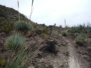
The Better Way! by imike  Unlike that great upper trail, the lower section is a slog over the often too rocky, rutted jeep road.
…or… you can take the time to locate the lower single track developed over the years by area mountain bike riders. This is the same group that developed the track connecting the official Indian Wells Trail cross country over to the Mineral Springs trail. Unlike the official route which charges straight up the hill in an ugly beeline, the bikers slung and looped and curved and rounded their route back and forth across the ridge. It is a pleasure. It is much kinder to the feet, too. It is best to hike this trail from the bottom the first time. In the upper half it crisscrosses the jeep road a number of times; it can be hard to follow until you adjust to how they do their layout. In a few areas where the jeep road is smoother, they route using the road. From the parking area at the east end of Indian Wells Road, hike east from the obvious trail on the far northeast corner of the lot… as you approach the levee, the trail splits… steeply ahead or more gently to the right. Both carry up to the top of the levee. The first part of the single track heads off from the top of the levee between those two split trail points. Find that point and follow it down and across the ditches, moving east over to the old pipeline roadbed. Turn right and follow that road over to the old jeep road turning to the east (the official Mineral Springs Trail). Follow that road east until you reach the gateway/fence marking the Forest Boundary. Here begins the adventure! The single track takes off immediately past the gateway, following the fence line south for awhile before turning east along the ridge. You will never be very far away from the road/official trail, but the route is a world away in aesthetics. Enjoy. Once you start crossing and re-crossing the jeep road, be on the lookout for the cairn marking the trailhead for the other single track heading across Mineral Springs Canyon North. It provides yet another exceptional bit of trail to enjoy. That route will carry you over to intersect the Indian Wells Trail. While this trail has been developed by mountain bike riders and is used by bike riders, most of the route crosses a variety of public and private lands wherein the use of bikes may not be fully sanctioned. Hiking... it's legal in all of the areas! Gate Policy: If a gate is closed upon arrival, leave it closed after you go through. If it is open, leave it open. Leaving a closed gate open may put cattle in danger. Closing an open gate may cut them off from water. Please be respectful, leave gates as found. The exception is signage on the gate directing you otherwise. Check out the Triplogs. Leave No Trace and +Add a Triplog after your hike to support this local community. One-Way Notice This hike is listed as One-Way. When hiking several trails on a single "hike", log it with a generic name that describes the hike. Then link the trails traveled, check out the example. | ||||||||||||||||||||||||||||||||||||||||||||||||||||||||||||||||||||||||||||||||||||||||||


