Route Editor

| Guide | ♦ | 19 Triplogs | 1 Topic |
details | drive | permit | forecast | 🔥 route |
stats |
photos | triplogs | topic | location |
| 157 | 19 | 1 |
Canyons are inherently risky. Flash floods occur without notice on sunny days. Technical skills & surrounding topography knowledge required yet does not eliminate risk.
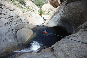
the potholes by knightwolf007  Overview OverviewFrye canyon is a sweet short canyon by Mount Graham. There is little to no beta online for this canyon, so I thought I would finally post some info on it to help others out. For such a good canyon, you get a good bang for your buck. Easy approach on a groomed trail without much elevation gain, and the hike out is as simple as hiking around the reservoir and back up a dirt road! You will get wet, and wetsuits would be needed if you are not doing this canyon in the dead of summer. The water was probably in the high 60s when we went in late August. Warning This canyon is extremely susceptible to fatal flash flooding. In sections, this canyon is very narrow, with no possibility of escaping a flash flood. The watershed upstream is huge, draining many square miles of the mountain up to its crest. Consider the current flow and look at other trips' historical data to gauge your comfort level with its flow (link below). Is there a possibility of heavy rain upstream? It can happen quickly, and there is a real possibility of death. Canyoneering in this type of canyon with potentially heavy rain is like playing Russian Roulette. You don’t want to be responsible for another’s death or your own due to ignorance.
I have passed on this canyon several times over the years due to flow or potential flash flooding. Be safe out there! : ) Know your canyon (including its watershed), its condition, and possible conditions (including the forecast). – Darrell (AZ-Outdoorsman) Canyon You will do a little bit of hiking until your first drop-in. Most of the raps in this canyon are well bolted. I would say the longest rappel in this canyon is about 125ft. There are a total of rappels of around 10. 1-2 are downclimbable. Keep an eye out for anchors at each rappel point because if you miss one and drop too far down, you may end up having to do a larger rappel. The last two rappels are kind of a 2 stage. Drop, stay on rappel, pop out of the pothole, and drop again. If the canyon is ever dry, they may become keepers, so be prepared for all conditions. You will come to a point where there is a handline canyon right to get down. Use these with caution! There is also a rappel after the handline on canyon left that has/had a guide rope to clip in with your anchor. This rope was a crappy nylon rope that was maybe 4-5 mm. The guideposts were metal "T" fence posts hammered into the rock side into holes that appeared to be drilled. The posts themselves are NOT very secure. Previous canyoneers rigged webbing off the last of these posts. Upon inspection of this post, it was loose, and the spine of the post was cut, thus reducing its structural integrity. These posts were initially used to keep the tubing for the reservoir system on the side of the canyon wall. Not meant for canyoneers to rappel off them! Anyway, barely pulling on this "anchor" snapped the post clear off the rockface, webbing and all tumbling down the face. You can scramble canyon left and literally walk down and avoid this rappel all together if you are careful. There is a bit of bushwacking in the middle of the canyon. You will come to a resting spot where you can see where you parked your car (if you continued up the high clearance vehicle road) before getting to the 2nd half of the canyon. Just follow the creek as best you can until the canyon opens up again. This part was my favorite as it had the most watery rappels :) Check out the Official Route and Triplogs. Leave No Trace and +Add a Triplog after your canyon trip to support this local community. | ||||||||||||||||||||||||||||||||||||||||||||||||||||||||||||||||||||||||||||||||||||||||||||||||||||||||||||||||