Route Editor

| Guide | ♦ | 12 Triplogs | 1 Topic |
details | drive | permit | forecast | route |
stats |
photos | triplogs | topic | location |
| 38 | 12 | 1 |
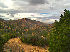
March to the Stronghold! by PrestonSands   Overview OverviewThe Middlemarch Canyon Trail 277 runs south from Cochise Stronghold, where it connects with the Cochise Trail 279, in southern Arizona's Dragoon Mountains. The Middlemarch Canyon Trail offers solitude among mountainous woodlands, views of Cochise Stronghold, and the chance to visit a historic mining area and ghost town site. The easiest place to begin this hike is at Cochise Stronghold Campground, which serves as the north trailhead. Accessing the south trailhead for the Middlemarch Canyon Trail requires at least a high clearance vehicle, although one could park on the maintained Forest Road 345 (Middlemarch Road), and hike north on Forest Road 4388/Forest Road 277 to the south trailhead.
History Middlemarch Canyon received its name from 19th-century U.S. Army soldiers, as it was the approximate midway point on a trail connecting Fort Huachuca to Fort Bowie. The Middlemarch Mine was discovered in Middlemarch Canyon in 1895, giving birth to a small mining camp known as Middlemarch. A post office was established on May 10, 1898, to serve the approximately 100 residents of Middlemarch. A mill was erected at the mine site by the Middlemarch Copper Company, and copper, zinc, and lead were the predominant metals produced. Further up the canyon, the Cobra Loma Mine was discovered. With the mining boom waning, the camp's post office was discontinued at the end of 1919, although some mining continued until the early 1950s. Middlemarch's only remains today are the mill's foundations, the mine itself, and a few scattered artifacts. 5.8mi RT Hike From the north trailhead at Cochise Stronghold Campground (mile 0.0 for this route), follow the Cochise Trail south into Stronghold Canyon. At 0.84 miles, the Cochise Trail arrives at a well-signed junction with the Middlemarch Canyon Trail. Turn left and continue south along the Middlemarch Canyon Trail, which follows the sandy bottom of Stronghold Canyon. At 1.4 miles, the trail passes through a fence and breaks into a small basin shaded by larger oaks and pinyons. A couple of hundred feet to the east, up a small side canyon, lies a large stock tank. The Middlemarch Canyon Trail leaves the basin and the creek bottom behind, heading south towards a high saddle. Views of the Stronghold's majestic rocks improve as the trail climbs, culminating in a nice rocky viewpoint at the 2-mile mark. At 2.25 miles, the trail reaches its highpoint at a saddle, where a gate in a barbed wire fence shows the way into Middlemarch Canyon. The green, wooded valley of Middlemarch Canyon is an attractive setting, with several lofty peaks and ridges hiding it from the Sulphur Springs Valley to the east. The route continues south from the saddle, and descends quickly to the sandy wash of Middlemarch Canyon, by way of a short, eroded, and somewhat treacherous stretch of trail. The trail weaves through oak woodland, always staying close to the wash, and arrives at the signed south trailhead at 2.9 miles (31.8878 N, 109.95521 W). The Middlemarch Canyon Trail ends here, becoming Forest Road 277. One can continue south along Forest Road 277 for another 0.8 miles to the Middlemarch Mine, and the former site of the Middlemarch mining camp, for a 7.4-mile round trip hike. It is also possible to continue all the way to Forest Road 345 (Middlemarch Road), which is 4.9 miles (one way) from Cochise Stronghold Campground. Gate Policy: If a gate is closed upon arrival, leave it closed after you go through. If it is open, leave it open. Leaving a closed gate open may put cattle in danger. Closing an open gate may cut them off from water. Please be respectful, leave gates as found. The exception is signage on the gate directing you otherwise.
Coronado FS Details Branching off the Middlemarch Road near the top of its climb up and over the Dragoon Mountains, this trail provides access into the remote backcountry of this history-rich mountain range. Middlemarch Pass was the half-way point on the route used by the military from the Sulphur Springs Valley to Tombstone. The trail passes through habitats that range from the upper Sonoran Desert, with its yucca and juniper, to higher elevation stands of oak and pinyon. Views are best early on along the trail where high elevation vistas encompass a portion of the sweeping Sulphur Springs Valley and the neighboring Chiricahua Mountains. Middlemarch Road and the trail of the same name were blazed into the Dragoon Mountains to provide access for mining and ranching purposes. Long before European society had brought its commercial interests to this mountain range, however, indigenous peoples such as the Chiricahua Apaches were no doubt using this route as a travelway to Cobra Loma Spring and on into the rugged canyon that came to be called Cochise Stronghold. Between the spring and the Stronghold, the trail is not well defined and can become confused with a number of cow paths that crisscross the area. Check out the Official Route and Triplogs. Leave No Trace and +Add a Triplog after your hike to support this local community. | ||||||||||||||||||||||||||||||||||||||||||||||||||||||||||||||||||||||||||||||||||||||||||||||||||||||||||||||||||||||||||||||||||||||||||||||||||||||||||||||||||||||||||||