Route Editor

| Guide | ♦ | 27 Triplogs | 2 Topics |
details | drive | permit | forecast | route |
stats |
photos | triplogs | topics | location |
| 343 | 27 | 2 |
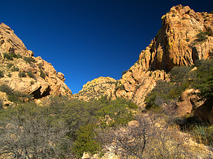
The Stronghold's lesser known backside by PrestonSands  Overview OverviewThe Slavin Gulch Trail 332 follows an old mining road deep into the western Dragoon Mountains' bouldered dells, near Tombstone, Arizona. In addition to the rugged scenic beauty and solitude of Slavin Gulch, there are ruins from a historic mining operation at the upper end of the trail. Two trailheads serve the Slavin Gulch Trail. However, the western trailhead is the easiest place to start, as the eastern (upper) trailhead requires four-wheel-drive, and that end of the trail requires an off-trail scramble down a steep mountainside.
Slavin Gulch is thought by some historians to be the location of the 1872 peace conference between Cochise and General Howard, as the description of their meeting area seems to fit Slavin Gulch better than the nearby Council Rocks. The Slavin Gulch Trail follows the route of a long-abandoned road used to haul ore from the Abril Mine, at the head of Slavin Gulch. The Abril Mine, named for Tombstone residents Manuel and J.S. Abril, yielded large amounts of zinc and copper from its extensive tunnel system during the first half of the twentieth century. Hike From the unmarked trailhead along Forest Road 687, the Slavin Gulch Trail heads east along the broad grassland floor of Slavin Gulch, on a well maintained and easily followed track. Conical buttes of bare Stronghold Granite rise all around, while oaks, mesquites, and catclaw thickets dot the canyon bottom. Up canyon, a large cliff face would seem to stop the upward progress of the trail. Approaching the cliff face one mile in, the route becomes apparent, and the Slavin Gulch Trail enters a narrow box below massive cliff walls. Numerous house-sized boulders create seasonal waterfalls in the creek bed, as the trail treads a narrow shelf on the south side of the drainage. Emerging from the box, the Slavin Gulch Trail enters a hidden valley of boulders and hoodoos, surrounded by rocky knobs and peaks. The trail continues northward, leaving the valley, and heading for a pass while following the path of an ancient, narrow road blasted from the granite bedrock. The track briefly becomes a little fuzzy as it parallels the creek bed into a second, lesser box, but a few cairns guide the way. Just over two miles in, the Slavin Gulch Trail breaks free from the confines of the second box and enters a larger hidden valley, where the greyish limestone crest of the Dragoon range comes into view to the east. The trail again follows the obvious route of the old road through the center of the valley for the next three-quarters of a mile, wading through manzanita thickets and past stately groves of Arizona Cypress. At the head of the valley, the trail turns north to climb the rapidly narrowing drainage of Slavin Gulch, through dense pinyon forest pierced by scores of jagged hoodoos. At around the three-mile point, the Slavin Gulch Trail stumbles into a small, steep-walled basin near the head of Slavin Gulch. At this point, the trail leaves the creek bottom behind to follow the ancient road on a circuitous path up the mountainside, passing a collapsed, metal-roofed cabin along the way. The Slavin Gulch Trail appears to come to a dead-end at three and a half miles (31.90822 N, 109.99412 W), where it encounters the elaborate ruins of the Abril Mine, whose rotted wooden structures cling precariously to the mountainside. Unless you are determined to reach the end of the trail, this is probably a wise place to turn around, as the final 0.2 miles to the road and trailhead above is a 400-foot vertical scramble up a steep scree slope of loose rock, brush, cacti, and slippery bedrock. However, the reward for this final scramble is a fantastic view down Slavin Gulch and of the surrounding peaks and valleys. Suppose you decide to go for the top, head south from the mine for a couple of hundred feet to a rocky drainage, where several scramble routes are possible. The easiest way (and what appeared to be the route of the "trail") seemed to be to stay near the mining structures and their associated tailings piles while following a drainage northeast. Whichever way you choose, you will reach Forest Road 345A at the 6600-foot contour. The end of this road, at (31.90797 N, 109.99233 W), is the upper or eastern trailhead. The trailhead is unsigned, but the Slavin Gulch Trail appears as a use trail heading north from the end of the road.
Coronado FS Details Water is present for most of the year in the larger pools of Slavin Gulch, which serves as the setting for most of this Dragoon Mountains trail. Slavin Gulch Trail connects two 4-wheel drive roads deep in the Dragoons, cutting a course that bears roughly southwest in the shadow of China Peak. There is plentiful evidence that the Apaches used this area heavily before prospectors and cowboys became the most common backcountry travelers in the Dragoons. Today, recreationists seek out secluded areas such as this to capture a feeling for the past. From the eastern trailhead and its good views of Tombstone and the Huachuca Mountains, the trail drops steeply into Slavin Gulch. Riparian vegetation such as sycamores and cottonwoods hold sway along the floor of the gulch while just a few feet away, plants of the upper Sonoran Desert affirm that this area can be hot and dry much of the year. Such a diverse habitat and remote setting make this a good place to encounter desert wildlife. Watch for coatimundi and Coues white-tailed deer as you scan the trees for some of the variety of songbirds that either make this small oasis a home or pass through it on their yearly migration. At the southwest end of the trail, access is from the end of a road that requires high clearance as well as 4-wheel drive. Check out the Official Route and Triplogs. Leave No Trace and +Add a Triplog after your hike to support this local community. | ||||||||||||||||||||||||||||||||||||||||||||||||||||||||||||||||||||||||||||||||||||||||||||||||||||||||||||||||||||||||||||||||||||||||||||||||||||||||||||||||||||||||||||||||||||||||||||