Route Editor

| Guide | ♦ | 7 Triplogs | 0 Topics |
details | drive | permit | forecast | route |
stats |
photos | triplogs | topics | location |
| 140 | 7 | 0 |
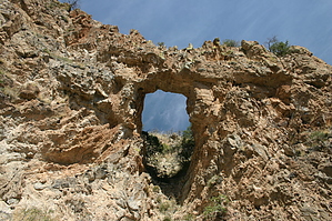
25 by 20 foot arch by PontifixMaximus   Overview OverviewThis arch has been relatively unknown which is somewhat surprising since this area has supposedly been scoured by people looking for gold and silver. Perhaps it is because the arch is not visible from the floor of the canyon or easily seen from Atascosa Peak it has escaped attention. I first spotted this 25 by 20 foot arch in 1988 from Atascosa Peak but did not think it was a real arch and it was not until I was attempting to climb Peak 6059 in 1995 that I spotted the arch and after a couple of misadventures finally stood under the arch in 2001.
The arch also has a designation of NABSQNO 12R-486930 3478540 Hike The hike starts at the hairpin turn where you should have parked. Follow the jeep road that heads west at this hairpin turn along the ridge. In a few hundred feet you should see a cairn for a faint trail that takes off on the south side of this road and heads west down the hill and eventually joins up with the 4WD road that went by Toruno Tank. Follow this road as it descends into Ramanote Canyon. The road is quite steep in spots being more like a bulldozer track than a road. Along the way, you will see the carcass of a belly-up truck serving as a reminder that it is not a good idea to drive the road. Cross the canyon and continue up the road until you spot an old silted in dam on the left and head for the area behind the dam where you will pick up a well-established picturesque “trash free” international use trail to where you get a good view of the very prominent butte (elevation 4833). This walk is very pleasant and when the creek is flowing and the flowers are in bloom. The canyon splits just before you reach this butte, the left side is the main canyon while the small canyon on the right heads off in the direction you want to go. If you walk past the small canyon a bit you should find a faint use trail that skirts a section of this canyons drainage. Just follow the use trail or the drainage for about a mile climbing up small waterfalls, etc. Keep left because you do not want to go up the drainage between Ramanote Peak and Peak 6069. The canyon will eventually start to close in and here is where you will need your GPS to locate the exit point where you climb up a steep slope gradually working your way toward a ridge that leads to the arch. If you do not have a GPS it will be tough finding the spot where you exit the canyon. It is just past a section where there is a granite wall on your left with several potholes in the granite floor. Just continue up the canyon looking for a major 15-foot tall chunk of a solid rock wall on your right with a couple of hundred-pound rocks perched on top. This is where you climb out on the right. If you go past this spot, the canyon starts closing in and travel gets a bit difficult. The steep slope that leads to the arch is fairly open but slow going with some miserable spots. Just keep plowing up to the ridge keeping on the east side until you run into a steep wall. Just skirt this wall heading west and in a couple hundred feet, you will wrap around a corner and see the arch on your right. Remember that no one in their right mind would even consider venturing up into this area unless they were looking for a route to Peak 6059 as the guide did in 2001 when he found this arch. The hike to the arch makes for a very enjoyable day in this beautiful area except for the 600-foot climb up to and down from the arch. I have posted a GPS track from the arch to the parking place. This track is the best route that I have found to the arch. In my photoset I have posted a picture of the butte 4833, a picture of the wall with the potholes in the stream bed, and the rock wall where you climb out as well as pictures of the arch, etc. Check out the Official Route and Triplogs. Leave No Trace and +Add a Triplog after your hike to support this local community. | |||||||||||||||||||||||||||||||||||||||||||||||||||||||||||||||||||||||||||||||||||||||||||||||||||||||||||||||||||||||||||||||||||||||||||||||||||||||||||||||||||||||||