 Route Editor

| Guide | ♦ | 5 Triplogs | 0 Topics |
details | drive | permit | forecast | 🔥 route |
stats |
photos | triplogs | topics | location |
| 50 | 5 | 0 |
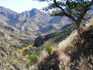
An instant classic. by Pivo  Overview OverviewThe traverse can work as a shuttle or, better yet, as a key swap. One group starting at the Lake in Redington on Bellota Ranch Road (R2CSP), heading West, and one begins in Catalina State Park heading East(CSP2R). Prepare for a long day and depending on available water sources plan on carrying four-plus liters. You can easily cache water at Gordon Hirabayashi Campground or Molino Basin Campgrounds. Warning Avoid the Summer months; try to plan this when there will be available water to filter/treat. You should be very fit. Trail Fit is different than Gym Fit. Gym Fit is excellent for Match.com, not so good here.
Heading East on the Romero Canyon Trail, we quickly made our way to the Romero Pools area. We dropped the extra layers we were wearing and continued to the Romero Pass segment of our hike. The trail was very overgrown in some areas, so there was a bit of route finding involved. In the upper segment of Romero Canyon, the trail was washed out due to the extra heavy rains in late September and early October. If you were coming from the East as part of a key swap late in the day, this area would be a problem with low or no light. I recommend downloading a GPS Track and using it. After arriving at Romero Pass, we dropped more layers and had a snack before continuing. The West Fork Trail will have plenty of sun exposure and drops 2300' in elevation over the first 6 miles. When we reached the creek, we were treated to a good flow and wonderful Fall foliage. From here, we started climbing again up the canyon for this segment heading East. Then descending the trail to the Hutch's Pool area. Warning If you are doing a key swap, it would be best to avoid Hutch's Pool. It is off of the main trail, and there would be a chance you could miss your other party with your key. We took a lunch break and filtered water creekside a little farther East, near the trail. Continue East on the West Fork Trail until the Junction with East Fork and Sabino Canyon Trail. Here is a bailout option; you can take the Sabino Canyon Trail to the tram road, catch the tram or walk the road to the Visitors Center. We continued on the East Fork to the Sycamore Reservoir Trail, taking that to Gordon Hirabayashi Campground. We didn't find any water here, there are toilets here, and Molino Basin Campground has toilets too. Upon reaching The Gordon Hirabayashi Campground, we hiked to near the end of the roadway in the campground before picking up the Molino Basin Trail. Taking that to the Molino Basin Campground. From there, we crossed the Catalina HWY and picked up the Bellota trail. That would take us back to our waiting vehicle near the Lake. When we crossed the highway, signage indicated it was 6.4 miles to the Bellota Ranch Rd. However, it was the longest 6.4 miles I have ever encountered. There is one final bit of elevation gain before dropping into the Redington Area of about 500' of gain. There was water at West Spring, La Milagroa, and the Agua Caliente Canyons. However, at that point, we were in the home stretch and did not stop to filter any water. We arrived at The Lake and my Land Cruiser just after sunset. All and all, a great day, with wonderful conditions. Check out the Official Route and Triplogs. Note This is a difficult hike. It would be insane to attempt this entire hike without prior experience hiking. Leave No Trace and +Add a Triplog after your hike to support this local community. One-Way Notice This hike is listed as One-Way. When hiking several trails on a single "hike", log it with a generic name that describes the hike. Then link the trails traveled, check out the example. | |||||||||||||||||||||||||||||||||||||||||||||||||||||||||||||||||||||||||||||||||||||||||||||||||||||||||||||||||||||||||||||||


