username
X
password
register
for free!
help


Hackamore Trail - MSPN, AZ

Guide 47 Triplogs  0 Topics
  2.8 of 5  
Fav
Wish
0
details
drive
no permit
forecast
route  
stats
photos
triplogs
topics
location
392 47 0
Statistics
tap row or icons for details
Difficulty 0.5 of 5
Route Finding 1 of 5
Distance One Way 1.8 miles
Trailhead Elevation 2,745 feet
Accumulated Gain 21 feet
Avg Time One Way 1 hour
Kokopelli Seeds 1.87
 Backpack No
feature photo
Photos Viewed All MineFollowing
Inaugural Calculation on Button Tap!
1  2024-01-14
McDowell Sonoran Preserve North
trekkin_gecko
10  2022-09-18
Cone Mountain
trekkin_gecko
10  2022-09-18
Cone Mountain
johnlp
9  2022-08-13
Axle Grease Trail
DarthStiller
30  2022-02-25
Hawknest Latigo Loop - MSPN
tibber
9  2020-08-29 DarthStiller
4  2020-04-12
Pima and Dynamite Black Diamonds
Nightstalker
7  2019-11-17
Cloudburst Trail - MSPN
DarthStiller
Page 1,  2,  3,  4
Author
author avatar Guides 31
Routes 135
Photos 2,699
Trips 615 map ( 2,220 miles )
Age 52 Female Gender
Location Scottsdale, AZ
Associated Areas
list map done
Phoenix Region
Historical Weather
Trailhead Forecast
Radar Map
Expand Map
Preferred Mar, Feb, Nov, Jan
Seasons   Late Autumn to Late Spring
Sun  6:03am - 6:49pm
Official Route & 4 Rts
 
16 Alternative


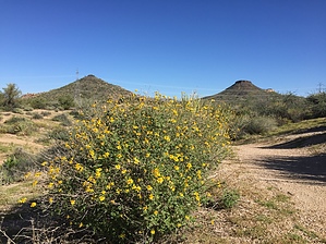
Perimeter segment & butterfly boulevard
by Crzy4AZ

  
The Hackamore Trail segment in the Northern region of the McDowell Sonoran Preserve (MSP) attracts mountain bikers looking for larger perimeter loops, hikers looking for an easy path, and bird and butterflies watchers.


The trail begins close to the equestrian parking area which is appropriate since a "hackamore" is a device used in a horse's bridle. There are two entry points: (1) if you climb up the little hill at the back of the large Brown's Ranch Trailhead parking lot - you will be at Sunset Point which connects to Hackamore Trail or (2) From the bathrooms go past the amphitheater headed up towards Jane Rau Trail and then turn right to the unnamed path 0.3 miles to trail marker HT1. Folks who are lucky enough to live in the nearby neighborhood may use the 0.2-mile trail from Alma School Road that leads to the HT1 marker.
remove free decal offer
From the HT1 marker, you will cautiously cross the road and begin up the small hill where you can climb a bit higher to get to Sunset Vista (2769 feet elevation). For out-of-town guests or the very young and very old hiker, this little hill is a nice spot to feel like you've climbed something and a great place for photographs. Continuing back on Hackamore, travel through relatively flat Sonoran desert with neighborhood visible to the south. If you are a bird watcher or butterfly enthusiast, this section of Hackamore Trail is lined with ample goldeneye and other host plants seasonally to attract pollinators and feeders.

At one mile you have the intersection with Powerline Road #2 Trail and 0.1 miles later is the intersection for Rustler Trail. Continue another 0.6 miles to the end of the Hackamore Trail segment where you may continue to follow the perimeter or make a loop with Cone Mountain Trail. As with most of the MSP trails, you can create endless loops with the various segments in the northern region depending on your skill level and time available.

(The 1.8-mile distance listed is for the 0.2 miles from Alma School to HT1 + 1.6 miles of actual trail starting at HT1)

2015-01-09 Crzy4AZ
  • MSPN Brown Insert
    area related
    MSPN Brown Insert
  • MSPN Trail List
    area related
    MSPN Trail List
  • MSPN Gate Schedule
    area related
    MSPN Gate Schedule
  • MSPN 2021 Map
    area related
    MSPN 2021 Map
  • MSPN 2021 Details
    area related
    MSPN 2021 Details


Check out the Official Route and Triplogs.
Leave No Trace and +Add a Triplog after your hike to support this local community.

One-Way Notice
This hike is listed as One-Way.

When hiking several trails on a single "hike", log it with a generic name that describes the hike. Then link the trails traveled, check out the example.
WARNING! Hiking and outdoor related sports can be dangerous. Be responsible and prepare for the trip. Study the area you are entering and plan accordingly. Dress for the current and unexpected weather changes. Take plenty of water. Never go alone. Make an itinerary with your plan(s), route(s), destination(s) and expected return time. Give your itinerary to trusted family and/or friends.

 Permit $$
None


 Directions
or
 Road
Paved - Car Okay

To Brown's Ranch Trailhead
From the 101 in North Scottsdale, drive North on Pima/Princess drive and go East on Happy Valley Road to the stop sign at the instersection of Happy Valley & Alma School Road. Follow Alma School Road North past Dynamite until it ends at Brown's Ranch Trailhead.

From PHX (I-10 & AZ-51) 34.0 mi - 44m
From TUC (Jct 1-10 & Grant) 135 mi - 2h 4m
From FLG (Jct I-17 & I-40) 139 mi - 2h 15m
page created by joebartels on Jan 09 2015 5:57 am
 90+° 8am - 6pm kills
helpcorrectionissue

end of page marker