Route Editor

| Guide | ♦ | 6 Triplogs | 1 Topic |
details | drive | no permit | forecast | 🔥 route |
stats |
photos | triplogs | topic | location |
| 54 | 6 | 1 |
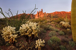
Unique views of Miner's Needle by JoelHazelton  Barkley Basin is one of the most beautiful areas of the Superstition Mountains. It may not have the most rugged topography, but it's vast, open, and full of lush desert vegetation. The crinkles caused by the washes cutting through the basin are enough to keep the terrain interesting, and during the spring, its colors come alive with wildflowers. In an effort to gain an overhead view of this amazing and peaceful area, I studied my maps a bit and came up with this route. It can be done as a moderate out and back hike, with time to soak in the views, or it can be made into a strenuous, several-hour loop, including a ridgeline traverse and a steep scramble down a vegetation-choked canyon. Either way, it's worth a visit at some point. Barkley Basin is one of the most beautiful areas of the Superstition Mountains. It may not have the most rugged topography, but it's vast, open, and full of lush desert vegetation. The crinkles caused by the washes cutting through the basin are enough to keep the terrain interesting, and during the spring, its colors come alive with wildflowers. In an effort to gain an overhead view of this amazing and peaceful area, I studied my maps a bit and came up with this route. It can be done as a moderate out and back hike, with time to soak in the views, or it can be made into a strenuous, several-hour loop, including a ridgeline traverse and a steep scramble down a vegetation-choked canyon. Either way, it's worth a visit at some point.The hike begins at the Peralta Trailhead, following the Dutchman Trail #104 over the first ridge and into Barkley Basin. In the morning this portion of the trail is a bit annoying, as you will be facing the sun the entire time. Continue past the Coffee Flat Trail #108 junction, around 2.8 miles, and push up to Miners Summit, which is about 4.4 miles into the hike. Turn right onto the Whiskey Spring Trail #238, which is much less traveled than the Dutchman. The trail climbs for just a bit and then dips down into a ravine, crossing it and ascending the other side on a smooth rock section. The trail contours here and then crosses the ravine again and arrives at a saddle, right at the top of the long descent into Whiskey Springs Canyon at about mile 4.8. This is where you will depart the trail. Turn right off the trail and head up, picking through the sparsely scattered cacti and other prickly things. There are some spots where the vegetation thickens, but it never gets too bad. The peak will soon come into view; stay to the west of it as you head up the hill. Soon you will be at the top. Stop here and rest, as the views are phenomenal, particularly the overhead view of Miner's Needle. The massive Coffee Flat Mountain juts out to the east, towering over Coffee Flats, and Barkley Basin spans directly below, spilling into Gold Canyon. Of course, Weaver's Needle shoots up to the east, providing a frame for Superstition Peak 5057 with Miner's Needle as the left side of the frame. Turn around here for a moderate 10.2-mile hike. If you desire more, however, then continue east on the ridge.
The descent into Whitlow Canyon is mighty steep with lots of loose scree. My trekking poles were invaluable in this section. The key here is to make switchbacks so as not to tumble or surf from the steepness (although you will still do both). As the bottom of the canyon starts to close in, travel on the mellow ridge on creek right is much easier than the vegetation-choked creekbed. The ridge ends and drops you off into the canyon, and you may have to cross a couple of times, but you will always end up on creek-right. Near where the walls jagged walls close in, you may spot a couple of cairns to guide you, but they don't help that much. When the canyon finally levels out, hop in the creekbed. It's about a mile of creekbed walking and hopping over some boulders before reaching the junction with the Coffee Flat Trail. Turn right here and follow the Coffee Flat Trail and Dutchman Trail back to the trailhead for a total distance of 12.7 miles. Although I described the entire loop here, once you enter Whitlow Canyon, the effort vs reward ratio depletes greatly. Like I mentioned before, a loop utilizing Whiskey Springs Canyon may be more sensible than Whitlow Canyon. Whatever you decide to do, the first peak and the ridge section are worth the hike. This hike is best done on a cool cloudy day. Every bit of it is exposed to the sun at all times of the day. Bring plenty of water. I drank a gallon on my hike. Enjoy! Check out the Official Route and Triplogs. Leave No Trace and +Add a Triplog after your hike to support this local community. | ||||||||||||||||||||||||||||||||||||||||||||||||||||||||||||||||||||||||||||||||||||||||||||||||||||||||||