Overview
After an easy rise, Whiskey Spring Trail #238 drops 558 feet down 2 miles to Red Tanks Trail #107 along LaBarge Canon. This trail makes backpacking and day-hikes deep into the wilderness possible. Albeit well-used, it is not near a trailhead. Battling catclaw is common when the hiking season picks up after a summer void of foot traffic.
Hike
From the west, beginning 4.25 miles in on Dutchman Trail #104. The Dutchman-Whiskey junction is well-signed. Whiskey Spring Trail #238 is the only trail heading east/right from the junction but is not always reassuring clear for the first few steps. The tread blends with the large light-colored soil where folks stand around pondering options.
The first half-mile is a delightful straightforward stroll to a subtle saddle, gaining 140-ft almost effortlessly. Weavers Needle is worth a gander to the West NW. Next, head down 0.8-miles to the Whiskey Spring oasis notable by two huge Freemont Cottonwoods. The tread and route are slightly erosion challenged but it's not difficult to decipher. A good quarter-mile before the oasis, nuisance catclaw might be present.
The side trail down to the spring and campsites is short and steep. It's easy to miss because you question it. The first steep drop is the way. There is another side trail to the oasis 2 strides further but it does not get as much use.
The final 0.7 miles down consistently presents two notables. Views of Upper LaBarge Canyon and distant views get you motivated. On the flip side, tangled catclaw to vegetation swallowed stretches of trail weigh on what the hell are you getting into? Typically still relatively early in the grand scheme you get 'er done, it's unlikely you're lounging around clipping catclaw for the next guy with adventure so near.
When you come to the creekbed in LaBarge Canyon you might question where to go. The end of the trail and junction with Red Tanks Trail #107 is often through overgrown vegetation straight across in 50 feet. Keep an eye out for the signed junction before getting down to creek level and it's easier to navigate.
Water Sources
Good beta is the water reports. Tap Whiskey Spring on the map water reports.
Camping
The campsite near the spring holds two small tents comfortably.
Synopsis
Trail #238 isn't crowding top 20 lists. It makes other cool hikes possible. Catclaw is typically worse on Red Tanks Trail so that is the lasting memory of pain.
[ 68-second video looping with Dutchman #104 ]
When hiking several trails on a single "hike", log it with a generic name that describes the hike. Then link the trails traveled, check out the example.
WARNING! Hiking and outdoor related sports can be dangerous. Be responsible and prepare for the trip. Study the area you are entering and plan accordingly. Dress for the current and unexpected weather changes. Take plenty of water. Never go alone. Make an itinerary with your plan(s), route(s), destination(s) and expected return time. Give your itinerary to trusted family and/or friends.
Permit $$
None
Directions
Road
FR / Dirt Road / Gravel - Car Okay
To Peralta Trailhead 7.6 miles east of the junction Idaho Rd / US-60. Turn Left on to FS77 which is Peralta Road. Follow FS77 5.6 miles to a left and up turnoff. Continue 1.9 miles to Peralta Trailhead.
The trailhead has restrooms minus running water. The parking lot is enormous. It does fill up in season on weekends. Since there are no lines, the rangers ask that you park straight between the posts in the main lot. Please do your part with this simple request and make room for the next guy. 0.5 miles before reaching the trailhead is an overflow lot, which is also suited for horse trailer parking.
From PHX (Jct I-10 & AZ-51) 45.2 mi - about 1 hour 8 mins From TUC (Jct 1-10 & Grant) 97.0 mi - about 2 hours 16 mins From FLG (Jct I-17 & I-40) 192 mi - about 3 hours 15 mins
 Route Editor

 Overview
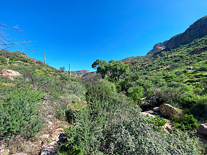


