Route Editor

| Guide | ♦ | 2 Triplogs | 0 Topics |
details | drive | permit | forecast | route |
stats |
photos | triplogs | topics | location |
| 11 | 2 | 0 |
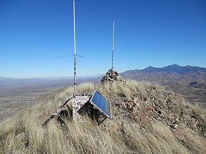
Hard work, great rewards by Pivo   Overview OverviewThe High Point of the San Cayetano Range near Rio Rico. First and foremost this is a bushwack, expect tall grass hiding rocks, and a very steep ascent to the peak. Warning Tall grass can make the stability a little rough. Recommend calf-high gaiters, gloves, and a trekking pole for descending the peak.
Park along the roadway, and head up the drainage on the East side of the road. We did find a faint footpath on the Southside on the drainage taking us up to a ridge. We followed the ridge and stopped for a minute to cross a barbed-wire fence. From this point, we worked our way Southeast, and after some discussion decided on a direct approach to the summit. We worked our way up a drainage just to the south of the peak. Most of the time I stayed out of it, working my way along the upper North Bank of the drainage, until getting high enough to take a dogleg to the North and work my way to a small saddle before summiting. At the peak, there were two radio antennas, no register. We left a summit register container. We didn't have a notepad, or anything else suitable for a register. So if you are planning on going, please take one. Everyone agreed that we would prefer to not descend the same way; mostly because it was very, very steep, with lots of rocks. We chose to go down the South side, descending a ridge to a saddle then working our way down this West slope, working a bit to the South to utilize more ridges. Until we made it back to the car. These ridges can be utilized for a less direct, and a safer approach is desired. Reverse my track to use as a guide to ascend the peak. Water Sources None Camping No Check out the Official Route and Triplogs. Note This is a moderately difficult hike. Leave No Trace and +Add a Triplog after your hike to support this local community. | |||||||||||||||||||||||||||||||||||||||||||||||||||||||||||||||||||||||||||||||||||||||||||||||