Route Editor

| Guide | ♦ | 6 Triplogs | 0 Topics |
details | drive | no permit | forecast | 🔥 route |
stats |
photos | triplogs | topics | location |
| 97 | 6 | 0 |
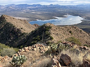
Perfect with a twist of Lime by John10s  Overview OverviewAt 4,598', Sunset Mountain is one of the highest peaks within ~ two miles of Horseshoe Reservoir in Tonto National Forest. The route described here is an extension of the hike to Lime Peak 3789, located ~1.5 miles south of Sunset Mountain. Including the hike up to Lime Peak along the way, the journey to the top of Sunset Mountain includes multiple points of interest: the two peaks, a benchmark (Lime), a frustum (Lime), Hohokam ruins (Sunset), and plenty of beautiful views of Horseshoe and the surrounding mountains. Long pants and gloves are recommended, as most of the hike is off-trail and passes through some brushy areas. When the water level in Horseshoe Reservoir is low enough, a shorter route to Lime Peak/Sunset Mountain is available by starting from the boat ramp on the reservoir's southwest side and crossing the lake's dry "arm". Triplogs contain detailed write-ups and GPS tracks for that option; this route bypasses that part of the reservoir when water levels are higher.
Refer to the guide for Lime Peak 3789 for a detailed description of the route to that peak. The short version is as follows: starting near the intersection of Horseshoe Dam Road and FR 1530, follow FR 1530 for roughly two miles, then leave the road and cross the wash at Lime Creek, continuing north for another two miles until you're almost directly east of Lime Peak, where you'll gain 1,000'+ in under two-thirds of a mile as you follow a ridge west to the summit. From Lime Peak, Sunset Mountain dominates the view looking north, with the high point (4598) on the left and a lower peak (4413) on the right. Continue north from Lime Peak ~300 feet past the frustum as you leave Maricopa and enter Yavapai County. As you hike farther north, you'll gradually lose elevation, passing a field of large granite boulders in the broad saddle between Lime and Sunset. Stay on the east side of Peak/Hill 3724, where you'll encounter one of the brushier areas on this section of the hike. The brush opens up again before long, and you'll soon see a barbed wire fence continuing toward Sunset Mountain, which makes the easy route finding that much easier. Stay on the east side of the fence and follow it north as you begin the second 1,000'+ climb on the route. The fence continues up the side of Sunset Mountain as the slope steepens. Footing is generally good, though the route crosses a few areas with some loose rock and talus, though there's no serious exposure on the way up. Like the ascent up to Lime Peak, there are several false summits on the way up Sunset. You'll reach the steepest section of the route just before gaining the ridge southeast of the summit, though there are still a few more obstacles to navigate before topping out at the peak. Following the ridge requires some some light scrambling and a few more encounters with brush, then a climb up one more short section with some loose rock. Multiple Hohokam walls come into view on the final ascent. Some are lower on the mountainside, but most are concentrated in a multi-room structure on the ridge south of the peak, with some small walls near the summit itself. It's unknown if this was a Hohokam lookout or habitation site; Sunset Mountain isn't normally listed among the peaks in the network of line-of-sight communication highpoints that some have hypothesized existed in this general area. Some of the lower walls appear to be defensive perimeter walls, and the site has very little pottery. Those factors, combined with the lack of nearby water sources, suggest it was likely a lookout of some sort, though with multiple rooms, the builders probably spent a fair amount of time at the site. From the main structure, the summit is a little farther north along the ridge, marked with a short piece of rebar protruding from a small cairn, with a summit register buried inside. Take the time to enjoy the hard-earned views--you'll have a unique perspective looking down toward Horseshoe Reservoir, with the Mazatzals beyond. Closer in to the east is Peak 4413, which provides an interesting view of the contrasting vegetation on the north and south sides of the mountain. The Superstitions and Weaver's Needle stand out on the distant southern horizon, and Lime Creek Cabin is visible far below to the northwest. Looking southwest, you can see Humboldt Mountain, Willow Spring Mountain, and the series of peaks that extend south from there. Once you've enjoyed the summit and the explored ruins, you can descend via the same route back to Lime Peak and down to FR 1530. Check out the Official Route and Triplogs. Note This is a moderately difficult hike. Leave No Trace and +Add a Triplog after your hike to support this local community. | |||||||||||||||||||||||||||||||||||||||||||||||||||||||||||||||||||||||||||||||||||||||||||||||||||||||||||||||||||||||||||||||||||||||||||||||||||||||||||||||||||||||||||||||