Route Editor

| Guide | ♦ | 4 Triplogs | 0 Topics |
details | drive | permit | forecast | 🔥 route |
stats |
photos | triplogs | topics | location |
| 13 | 4 | 0 |
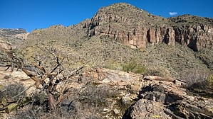
follow ridge to cliffs by mbookman  Overview OverviewAfter crossing an easement between housing developments, the trail enters the Coronado National Forest and climbs several hills to reach a saddle that terminates at the base of large red cliffs visible from Campbell Ave. Great unobstructed views of Pima Canyon and Tucson. Also possible to climb over the cliffs, to the East (toward Finger Rock), or descend to connect with Pima Canyon Trail. Warning Many loose rocks during the initial half-mile, between housing developments. 40% grade to reach cliff base, also with many loose rocks.
The initial half-mile from N Campbell Ave parking lot to the border with National Forest was cleared by local volunteers in cooperation with Pima County Parks in 2014. The current route within Coronado National Forest is marked with rock cairns. Suggestions for improvement and changes are welcome. Hike Access from the parking lot at the top of N Campbell Ave. Alternative access from wash within Sin Vacas' gated community. The initial 0.5 miles follow an easement between Sin Vacas and Cobblestone developments, with a chain-link fence on both sides. Lots of loose rock in this segment. After entering the National Forest, climbs several hills, with nice views over Tucson. Portions are steep (40%) with loose rock, but some areas are stabilized. Eventually reaches the West end of a saddle that fills the gap between tall red cliffs on both sides. Crossing the saddle provides panoramic 360-degree views of Pima Canyon and Tucson. After the final 40-degree climb, reaches the base of the large cliffs. There is also marked access to climb over the cliffs (North-most corner), and continue above (extension of the trail above cliffs included on the official route). Generally requires 2 hours to climb. The majority of the hike is within full sunlight. On the return, it is possible to take a partial loop descent into the East wall of an adjacent canyon (overlooking Sin Vacas' community, see GPS route. This is also marked with rock cairns and rejoins the main trail after winding around to the East (this portion is shaded all morning). Water Sources Small wash with seasonal pools at the entrance to National Forest. Camping Possible at the flat portion of saddle overlooking Pima Canyon. Gate Policy: If a gate is closed upon arrival, leave it closed after you go through. If it is open, leave it open. Leaving a closed gate open may put cattle in danger. Closing an open gate may cut them off from water. Please be respectful, leave gates as found. The exception is signage on the gate directing you otherwise. Check out the Official Route and Triplogs. Leave No Trace and +Add a Triplog after your hike to support this local community. | ||||||||||||||||||||||||||||||||||||||||||||||||||||||||||||||||||||||||||||||||||||||||||||||||||