username
X
password
register
for free!
help


South Newman 4209, AZ

Guide 19 Triplogs  1 Topic
  4 of 5  
Fav
Wish
0
details
drive
permit
forecast
route  
stats
photos
triplogs
topic
location
322 19 1
Statistics
tap row or icons for details
Difficulty 4.5 of 5
Distance One Way 2.12 miles
Trailhead Elevation 4,210 feet
Elevation Gain 2,362 feet
Accumulated Gain 2,362 feet
Kokopelli Seeds 9.99
 Interest Off-Trail Hiking & Peak
unreported if dogs are allowed
editedit > ops > dogs to adjust
feature photo
Photos Viewed All MineFollowing
Inaugural Calculation on Button Tap!
49  2025-02-06 Mike_W
10  2025-01-02
New Year - New Man
chumley
36  2023-11-22
Picacho Ridgeline Attempt
thesnakefromthel
14  2023-05-20
South Newman South Ascent
thesnakefromthel
25  2022-12-19
Newman Peak loopish
The_Eagle
15  2022-12-19
Newman Peak Trail
chumley
12  2020-01-25
Newman Peak Trail
chumley
15  2015-11-08
Newman Loop
chumley
Page 1,  2
Author
author avatar Guides 16,843
Routes 17,472
Photos 24
Trips 1 map ( 6 miles )
Age 28 Male Gender
Location HAZ, TrailDEX
Associated Areas
list map done
Tucson Region
Historical Weather
Trailhead Forecast
Radar Map
Expand Map
Preferred Apr, Oct, Mar, Nov
Sun  6:02am - 6:47pm
Official Route
 
6 Alternative


remove free decal offer

  
Guide Needed
Publish Full Detail Guide


Use +Add above to share photos and triplogs
The dramatic southern brother to nearby Newman Peak.


Happy

Trails!


    Check out the Official Route and Triplogs.

    Note
    This is a more difficult hike. It would be unwise to attempt this without prior experience hiking.
    Leave No Trace and +Add a Triplog after your hike to support this local community.

    One-Way Notice
    This hike is listed as One-Way.

    When hiking several trails on a single "hike", log it with a generic name that describes the hike. Then link the trails traveled, check out the example.
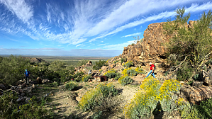
    WARNING! Hiking and outdoor related sports can be dangerous. Be responsible and prepare for the trip. Study the area you are entering and plan accordingly. Dress for the current and unexpected weather changes. Take plenty of water. Never go alone. Make an itinerary with your plan(s), route(s), destination(s) and expected return time. Give your itinerary to trusted family and/or friends.

     Permit $$
    AZ State Recreational Land Permits
    For hiking, driving & sightseeing purposes, you seek a recreational permit.
    Under "Recreational Land Use" in the link above.
    2022 - $15.00 individual
    2022 - $20.00 family limited to two adults and children under the age of 18
    Plus $1 processing fee
    The permitting process is quick, you will be emailed your permit instantly.

    Land Parcel Map


     Directions
    or
     Road
    High Clearance possible when dry

    To hike
    Located about halfway between Phoenix and Tucson. Travel on I-10, exiting the freeway at Exit 211, about 10 miles south of Casa Grande. Travel north on AZ-87 just half a mile and turn right onto Milligan Road. Travel 3 miles on paved road, before the road turns to dirt. Continue 1.25 miles to the CAP canal bridge. Proceed through a gate and veer left (continuing an eastward orientation). Avoid the more traveled road that veers to the right after the gate. Drive 1 mile from the gate on a sandy road to the powerline road and turn right. Follow the powerline road 1.5 miles to a T-intersection and turn left to parking area at the canal. A pedestrian bridge over the canal is 100-feet away.
    (Note: The powerline road is somewhat rocky with some small wash crossings. High-clearance is required, but 4wd is not necessary). Driving route is available for GPS.
    page created by chumley on Mar 02 2015 12:23 pm
     90+° 8am - 6pm kills
    helpcorrectionissue

    end of page marker