Route Editor

| Guide | ♦ | 43 Triplogs | 1 Topic |
details | drive | permit | forecast | route |
stats |
photos | triplogs | topic | location |
| 513 | 43 | 1 |
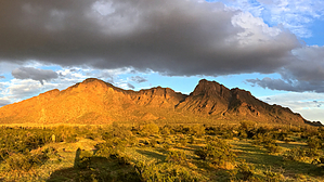
Hello, Jerry! by chumley  Note NoteGoogle might get you lost. Take the supplied driving route and understand it and the area before heading out for best odds. Overview Newman Peak is the tallest peak in the Picacho Mountains and rises to an elevation of 4511 feet. Despite being more than 1100 feet higher, Newman often plays second fiddle to Picacho Peak, its iconic neighbor just over 5 miles to the south. The overgrown and eroded remains of an old trail built in the 1930s leads up the western slopes to the summit.
Much has changed since this trail was built – most significantly the CAP canal which now traverses the base of the mountain and makes it necessary to cross a remote canal bridge to access the former roadbed to the old mine. While the peak itself lies on BLM property, the approach is on State Trust Land (permit required) with pockets of private property. Download the GPS route with driving directions to make getting there easy. The Hike Start at the small parking area and head south to the bridge which crosses the canal. On the other side, head north again to find the old alignment of the road you parked on, which hasn’t been driven since the canal was constructed. Follow the roadbed for about .75 miles toward the tailings of an old mine. Stop and explore the mine area if you wish or continue up the drainage toward the peak. From here the route is an old trail marked with frequent cairns. The footing of the old trail can be seen in many places but is overgrown in others. A keen eye can follow the original route. At about 1.25 miles you will reach a large boulder spray-painted with an arrow. Ignore the paint and continue around the rock and continue on the old tread which parallels the main drainage. The old trail grade begins to get steeper as you climb the drainage. At about 1.9 miles the trail cuts steeply to the left, through some of the thickest brush you will encounter. From here, the old route climbs very steeply up a narrow chute where some remnants of constructed switchbacks exist, but where you will mostly climb via whatever route is easiest for you, gaining 500 feet while traveling just 0.3 miles to a scenic saddle. Along the way, you’ll pass some more spray-painted directions that are a testament to the idiocy of those who have hiked here before you. From the saddle at the top of the chute, the trail becomes more obvious once again and traverses the slope for about 100 yards before beginning a series of switchbacks up the final 400 feet to the summit. The old route here features remnants of beautifully constructed switchbacks as well as steps built into the side of the mountain. On the summit, modern technology has taken over and numerous antennae, buildings, fences, and a helicopter landing pad dominate, though excellent views can be found in all directions. You may return by the same route or you can make a loop traveling the treacherous off-trail ridgeline traverse toward South Newman 4209 and follow the much-less traveled route down from the saddle ¼ mile east of that peak, which connects back to the route that leads back to the canal bridge and your parked vehicle. The loop return will add about an hour though not much more mileage to the stats posted. (An out-n-back trip to South Newman 4209 adds an additional mile and about an hour.) History So why is there an old trail to the summit of Newman Peak!? All my research points to the 1930s and the installation of an old airway beacon. In 1931 the beacon installed on Newman Peak completed the airway from El Paso to Phoenix. Previous airways had been established from Dallas to El Paso and from Phoenix to Los Angeles, so this completed the first possible nighttime flying route from Dallas to the west coast where pilots could “connect the dots” from one beacon to the other. Beacons were placed along the route at approximately 15-mile increments as well as on landmarks and mountaintops. Some of the beacons could be seen for 70 miles! Installation of the 2-ton beacon required building roads or trails to access, and a tramway may have been set up to carry the equipment up the steepest part of the mountain. The beacons were powered by generators that were supplied with about two months of fuel at a time. Solar switches turned them on at sunset and turned them off again at sunrise. Despite only being fueled every two months, they were checked weekly by inspectors. Those weekly visits by inspectors and bimonthly refueling trips (likely by pack animals) are the probable reason this trail was built and maintained. Airway beacons began to be replaced by radio navigation almost immediately, though they were not officially discontinued until 1973. I have not been able to determine when the beacon on Newman Peak ceased operation or when it was removed. Check out the Official Route and Triplogs. Leave No Trace and +Add a Triplog after your hike to support this local community. | ||||||||||||||||||||||||||||||||||||||||||||||||||||||||||||||||||||||||||||||||||||||||||||||||||||||||||||||||||||||||||||||||||||||||||||||||||||||||||||||||||||||||||||||||||||