 Route Editor

| Guide | ♦ | 10 Triplogs | 2 Topics |
details | drive | permit | forecast | route |
stats |
photos | triplogs | topics | location |
| 249 | 10 | 2 |
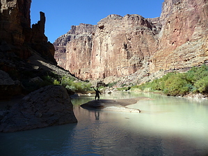
Embrace the Humpback Chub! by ckoss_   Overview OverviewThe confluence of the mighty Colorado River and the colorful Little Colorado River is more than a stunning landmark of Marble Canyon, but of spiritual importance to the many indigenous tribes. This section of the trail links the Beamer Trail in Grand Canyon National Park to the Hopi Salt Trail of the Little Colorado River Tribal Park of the Navajo Nation Parks and Recreation. History The Little Colorado River (and especially the confluence) is significant to many indigenous tribes, as many believe life originates from this area, such as the Sipapu (place of emergence) partway down this trail. Also, Ben Beamer's 1890s cabin still exists in the Tapeats sandstone near the confluence. The LCR is home to the endangered Humpback Chub, which several wildlife groups periodically study its population.
The trail through the Little Colorado River gorge between Beamer Trail and the Hopi Salt Trail spans the Grand Canyon National Park and the Navajo Nation. The park boundary can be found by viewing the Backcountry Use Areas Map and is approximately 2 miles east of the confluence. Swimming is not permitted in the southern section of the LCR from the confluence to the park boundary to the east to preserve the endangered Humpback Chub. To hike this entire section a permit is required from the Navajo Nation Parks and Recreation. As always, a Grand Canyon Backcountry permit is required when camping below the rim. Hike This trail can be approached from either direction: the Beamer Trail or the Hopi Salt Trail. From the Beamer Trail and the confluence, the trail remains on the south side of the LCR until a series of travertine rock formations span nearly the width of the river, making it straightforward to cross to the north side of the river where the Hopi Salt Trail junction is located. The trail typically weaves in and out of the brush along the river. The trail near the confluence features a few cliff benches above the river, and many USGS river monitoring stations are located. After crossing the river, the trail is engulfed by catclaw and dense brush until making it to the Hopi Salt Trail junction. Water Sources The blue water of the LCR contains calcium carbonate, leading to an undesirable taste. It is best to carry water from the Colorado River. Camping No camping is permitted on the helicopter landing pad at the junction with the Hopi Salt Trail. There is a site near the LCR below the landing pad. Note: a permit is required from the Navajo Nation Parks and Recreation. Note The color of the LCR varies depending on the flow rate of the river. During heavy rain, the LCR turns to a muddy brown color. Generally, the favorable time to observe the blue waters is winter through late spring. There are mathematical methods to provide a fairly accurate prediction on whether the water will be blue. Track the USGS river discharge flow rate data stations near the confluence and near the spring: aim for equilibrium values of 220 ft3/sec and 0 ft3/sec, respectively. The USGS website has the ability to subscribe to real time water alerts. Check out the Official Route and Triplogs. Leave No Trace and +Add a Triplog after your hike to support this local community. One-Way Notice This hike is listed as One-Way. When hiking several trails on a single "hike", log it with a generic name that describes the hike. Then link the trails traveled, check out the example. | |||||||||||||||||||||||||||||||||||||||||||||||||||||||||||||||||||||||||||||||||||||||||||||||||||||||||||||||||||||||||||||||||||||||||||||||||||||||||||||||||||||||||||||||||||||||||||||


