|
| | | Grandma Spit Trail to Hopi Salt Trail, AZ | | | |
|
|
Grandma Spit Trail to Hopi Salt Trail, AZ
| | |
| |
|
| Backpack | 34.26 Miles |
6,217 AEG |
| | Backpack | 34.26 Miles | 2 Days 6 Hrs 50 Mns | | |
| 6,217 ft AEG | | 20 LBS Pack | | |
|
|
| |
| Partners |
|
none
[ show ]
| no partners | | Preface
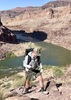
The goal for this trip was to hike from Lipan Point to the Hopi Salt Trail on the Navajo Nation with 2 nights along the Colorado River. The group consisted of 1 experienced Grand Canyon hiker, 1 that has day hiked below the rim, and 2 hikers brand new to the Grand Canyon. In May 2024, I previously completed the Escalante Route from Tanner Trail to Grandview Trail, so I was already familiar with Tanner. Everyone in the group is a strong hiker/backpacker and April was a great time to do this itinerary especially since the Little Colorado River was blue! We planned to camp at Cardenas Beach (BC9 - Cardenas, At-Large Camping) and 0.5 mi down river from the Little Colorado River (LCR) confluence (BA9 - Palisades, At-Large Camping). Ideally, we wanted Tanner Beach on night 1, but a last minute date change made that not possible. This itinerary changed enabled us to attempt an alternate route to descend the Redwall and Tapeats layers from Tanner Trail, called the Cardenas Route or Grandma Spit Trail. More information on this route can be found from Doug Nering, Harvey Butchart, and Green/Ohlman. Breifly, descending this route with overnight packs proved to be very strenuous, more than what I expected. This was the first time that daylight savings became relevant while backpacking since we left AZ time and entered Navajo Nation (observes Daylight Savings).
Permits
This itinerary spans the Grand Canyon National Park and Navajo Nation, so 2 permits are needed: 1) Grand Canyon Backcountry permit and 2) Navajo Nation Parks and Recreation.
Predicting LCR Color
There are 2 USGS monitoring stations that are useful to provide a quantifiable prediction on whether the LCR will be its dazzling blue color. The USGS river discharge flow rate data stations near the confluence and near the spring: aim for equilibrium values of 220 ft3/sec and 0 ft3/sec, respectively. The USGS website has the ability to subscribe to real time water alerts.
Day 1
The first day began with an overload of excitement as we attempted a "short cut" from Tanner Trail to Cardenas Beach. I studied the descriptions of the route several times, including an recent trip report with photos. We started down Tanner at noon and made it to the start of the route at 2PM, which is marked by a couple rock cairns to the left of Tanner right below the drainage leading up to the saddle nearest Cardenas Butte. The view from the top of the saddle was spectacular as we saw the Colorado River bend past Unkar Delta and we were able to size up the monumental height of the Redwall across to the north, where we would descend down its drainage. The route has 2 main milestones: 1) the Redwall Break and 2) the Tapeats Cliffs. This formation on maps / satellite looks like a horseshoe shape. We contoured along the Supai making our way over to the head of the Redwall ravine. There was some loose rocks, but it was manageable with out overnight packs. We took a slight detour, passed the turn off for the Redwall to get another view of the ravine from above. There is a cairn that signifies when to start the descent to the top of the ravine. The descent through the Redwall ravine was surprisingly straight forward. There was a lot of lose scree as we continued below the ravine as we made it to the plateauabove the Tapeats. This section was difficult with overnight packs due to the constant battle of steep, loose scree. Perhaps we descended too soon and should have contoured more first. We were awarded with lots of pink prickly pear cacti blossoms. The final challenge of this route is descending the Tapeats Cliffs with our overnight packs and windy conditions. I knew the break was on the left side of the plateau, but you cannot see it until you are standing right on the edge. Once beyond the edge, an obvious chimney appears and we carefully descended one by one to ensure we did not topple each other with debris. The route then follows the top of the Basalt layer to the north. Again, it takes some time to locate the break to descend. There is a steep series of Basalt "steps" that can be climbed down with some hand work. The large boulders were key to preserve our strength since they generally did not dislodge when hopping on them unlike the ubiquitous scree. We finally reached the drainage at the base of the Red Dox hills at sunset (7PM). We quickly scurried up the slopes to meet the Escalante Route, which greeted us with actual trail! We continued above the Unkar Rapids and made our way to Cardenas Beach, where we spotted lights from afar. A river group of 11 were already setup. We chatted briefly. I slept without my tent and enjoyed the vivid night sky with a new moon while reflecting on our descent.
Day 2
This was the easiest day of the trip since it was all on actual trail, mostly the Beamer Trail. The river group offered us an extra breakfast sandwich so we split it 4 ways for our group. We started hiking towards Tanner Beach at 8AM. The drainage near Tanner Beach looked very different from a year ago. No white sand and a lower water level. Tanner Beach also has a composting toilet, which is convenient. We also ran into a hiker from NJ who shared similar mtn biking locations as us. We continued onto Beamer Trail and took a relaxing break at Palisades beach around 1PM. We planned to camp at the debris fan / beach that is 0.5 miles south of the confluence. The exposure of Beamer Trail was minimal compared to the route from yesterday. We arrived around 5PM and set up camp towards the southern end of the "beach". We could see hints of blue water from the confluence. We also celebrated on our groupmates Birthdays!
Day 3
The highlights for the final day were seeing Beamer's Cabin, seeing the USGS monitoring stations, crossing the LCR, and ascending the Hopi Salt Trail. We expressed some doubt on the best spot to cross the LCR since there were several options. We opted to cross at the Travertine ledges just up river from the biologist's camp. The trail along the LCR was very easy going up until the crossing spot. After crossing the LCR, we were faced with overgrown catclaws and lots of muddy trails all the way to the helicopter landing pad. I think there is a high route to bypass. We started the ascent to the rim at 3PM as clouds began to approach from the west. The Hopi Salt Trail had lots of historic rock cairns marking the way. The final ascent to the rim is quite steep once crossing the drainage atop the Redwall. Be sure to keep an eye out for petroglyphs near the rim. We were greeted with a colorful sunset as we met our driver at the trailhead. |
|
Wildflowers Observation Light
|
|
| | |
|
|
|
 Route Editor