Though predating the Incinerator Ridge Trail #18A, when taken with that trail, Trail #45 seems like it was built to complete trail #18A. The sign for the trailhead is at the end of the Incinerator Ridge Road, and it can easily be hiked as an out and back from that point to Mount Bigelow, and with no other trails included. This write-up is for that purpose.
The current trailhead sign is the metal post at the start of trail #18A, though the arrow for this trail points back towards the parking area. There is no other sign for this trail at the trailhead, at this writing, that I could locate. It takes a slight amount of effort to locate the trail, and you will have to pass through a camping area that might have some folks camped in it, but once on the trail, it is impossible to leave it accidentally. From the parking area, hike uphill towards Mount Bigelow, on the ridge between the cliff on the right and the road on the left; this will take you to the trail. You'll be 100% sure when you are on the trail.
Trail #45 hikes up through shrub oaks and a series of switchbacks, going around what must be Kellogg Mountain, but not over it. It stays on the western side of the ridge for most of its journey. Just past an area of grass and pines, it can be said to either intersect or end at the Mount Bigelow Trail or what should be that trail. It probably ends at this point or does officially, but being so close, the stats take you to Mount Bigelow Road. A USFS sign at the junction is titled for the "Butterfly Trail", and neither makes any references to trail #45 nor does the sign have any arrows for the trail going to the Incinerator Ridge Road, indicating it was probably built after this sign was installed. Signs in this area of the Coronado NF can be confusing. From Mount Bigelow, you can hike back the way you came or use other trails to create a longer loop.
When hiking several trails on a single "hike", log it with a generic name that describes the hike. Then link the trails traveled, check out the example.
WARNING! Hiking and outdoor related sports can be dangerous. Be responsible and prepare for the trip. Study the area you are entering and plan accordingly. Dress for the current and unexpected weather changes. Take plenty of water. Never go alone. Make an itinerary with your plan(s), route(s), destination(s) and expected return time. Give your itinerary to trusted family and/or friends.
Permit $$
None
Coronado Forest MVUMs are rarely necessary to review unless mentioned in the description or directions Coronado Motor Vehicle Use Maps (MVUMs)
Directions
Road
FR / Dirt Road / Gravel - Car Okay
To hike Take the Catalina Highway off Tanque Verde Road in Tucson up into the mountains. The Green Mountain and San Pedro Vista parking areas are at milepost 18. A short way beyond this, a gravel road takes off to the right, signed as Incinerator Ridge Road. Turn onto this road and drive between 0.25 to 0.5 miles up to the end. The road is a mildly bumpy and rocky, but a passenger car can make it as long as you go slow. If you see the Palisade Visitor Center on the Catalina Highway, you have passed Incinerator Ridge Road.
 Route Editor

 Though predating the Incinerator Ridge Trail #18A, when taken with that trail, Trail #45 seems like it was built to complete trail #18A. The sign for the trailhead is at the end of the Incinerator Ridge Road, and it can easily be hiked as an out and back from that point to Mount Bigelow, and with no other trails included. This write-up is for that purpose.
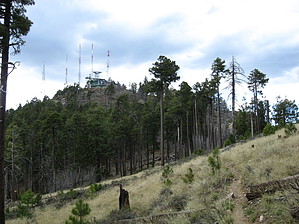


