Trail data given is only for Terrapin Trail #234 itself. The hike described here is the popular loop. Check out Weavers Needle Loop for complete loop distance & stats.
Terrapin trail is part of a 12.9-mile loop per the GPS unit that starts from Peralta Trailhead and circumnavigates Weaver's Needle. The entire trip is just under 6 hours which allows for plenty of stops to rubberneck and enjoy the views. As the series of trails are well maintained, route finding is not an issue except for in some short stretches.
The trip begins as you leave Peralta Trailhead on Dutchman Trail #104 for a hundred yards to the Bluff Springs Trail #235 turn off. Take Bluff Springs Trail up over the ridge and follow it down Barks Canyon. A quick note regarding the topo maps. On the topo maps, they label the trail up Barks Canyon as Dutchman Trail but the trail markers call it Bluff Springs. Furthermore, while the actual trail markers call it Terrapin Trail, it is labeled Needle Trail and Needle Cutoff Trail on the topo map. It's all the same trail, just don't let the different names confuse you.
After about an hour on Bluff Springs Trail, you will come to the Terrapin Trail cut-off. The intersection is well signed and Terrapin Trail heads west across the wash and up the canyon to Bluff Saddle. This trail is not well cairned, (it doesn't need to be in most spots), and it is easy to get off trail on this climb if you're not paying attention. As long as you keep heading up, you should be just fine. After Bluff Saddle you head north through a valley-like area that is surrounded by miniature hoodoos on either side. After this point, the trail begins to descend into Needle Canyon and the vegetation and cat claw get much thicker. While the trail is by no means overgrown, the catclaw will scratch you up if you try "beat feet" through it. As one proceeds north/northwest up this canyon you will be afforded stunning views of Weavers Needle to the west. As you pass Weavers Needle, the trail begins to climb up to Terrapin Pass.
Terrapin Pass is more of a saddle than a pass, but it grants you great views of the surrounding terrain. The view northwest is of Black Top Mesa, Palomino Mountain, and Black Mesa off in the distance. Of course, Weavers Needle is to the south. Looking down the trail directly to the north you can clearly see where the tail is heading down the canyon to the intersection with the Dutchman Trail. Even further north of this intersection, you can make out the area, (on a clear day), where the Dutchman Trail intersects the Bull Pass Trail. Be careful going down the north slope of Terrapin Pass as the trail is dominated by loose rock and scree. To your right in the eastern wall of the canyon, you can make out where several mines were located. Eventually, the trail levels out as it follows the creek bed due north. Along this wash, you will notice the remains of a stone wall that formed some sort of a catch basin for runoff. The intersection of Terrapin and Dutchman Trail is signed and heading west on this will take you over a saddle at the base of Black Top Mesa and down to Boulder Canyon. From the top of this saddle, you get a clear view of the Peralta Tail heading up the west side of Boulder Canyon and back to Freemont Saddle, the Peralta Trailhead, and home. The trail intersection of Dutchman and Peralta Trail is signed and just west of the wash at the bottom of Boulder Canyon.
When hiking several trails on a single "hike", log it with a generic name that describes the hike. Then link the trails traveled, check out the example.
WARNING! Hiking and outdoor related sports can be dangerous. Be responsible and prepare for the trip. Study the area you are entering and plan accordingly. Dress for the current and unexpected weather changes. Take plenty of water. Never go alone. Make an itinerary with your plan(s), route(s), destination(s) and expected return time. Give your itinerary to trusted family and/or friends.
Permit $$
None
Directions
Road
FR / Dirt Road / Gravel - Car Okay
To Peralta Trailhead 7.6 miles east of the junction Idaho Rd / US-60. Turn Left on to FS77 which is Peralta Road. Follow FS77 5.6 miles to a left and up turnoff. Continue 1.9 miles to Peralta Trailhead.
The trailhead has restrooms minus running water. The parking lot is enormous. It does fill up in season on weekends. Since there are no lines, the rangers ask that you park straight between the posts in the main lot. Please do your part with this simple request and make room for the next guy. 0.5 miles before reaching the trailhead is an overflow lot, which is also suited for horse trailer parking.
From PHX (Jct I-10 & AZ-51) 45.2 mi - about 1 hour 8 mins From TUC (Jct 1-10 & Grant) 97.0 mi - about 2 hours 16 mins From FLG (Jct I-17 & I-40) 192 mi - about 3 hours 15 mins
 Route Editor

 Trail data given is only for Terrapin Trail #234 itself. The hike described here is the popular loop. Check out Weavers Needle Loop for complete loop distance & stats.
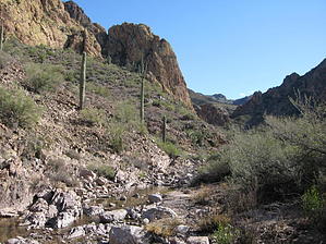


