Route Editor

| Guide | ♦ | 24 Triplogs | 1 Topic |
details | drive | no permit | forecast | 🔥 route |
stats |
photos | triplogs | topic | location |
| 27 | 24 | 1 |
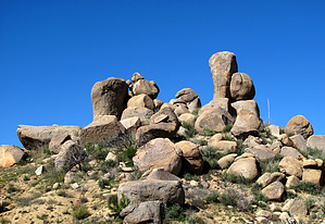
All about interesting Rock Formations by Grasshopper   Overview Overview3.6-mi from the Ballantine Trail #283 TH off Hwy 87 is an unmarked, well-defined spur-connector trail heading to the right (southwest) and connecting 4.8 miles later with FR143 (the Four Peaks Road). This mystery trail, first documented by GPSjoe now provides some new and interesting hiking options for hiking via the Hwy 87 TH and/or hiking this, the Ballantine Connector Trail to FR143. With these two TH options, one can plan a shuttle hike utilizing the Ballantine Trail #283, and this hike, do an in and out hike or start/end here for another option in doing the Ballantine Cabin & Corral Hike. Hike This description details only the option for an "in and out lasso loop hike" starting & ending at the TH Start location on FR143 (The Four Peaks Road). Please see notes under Driving Directions for pertinent information regarding the Parking location and this TH Start location.
Note On your return hike out, you may choose as I did, to take the well-defined spur connector trail that heads in an easterly direction for 0.3-mi to end a little further uphill from your parking location on FR143 (N33 43.437 W111 27.002). From this above and described cairned 3-way trail intersection, continue hiking north on this unmarked and mostly not cairned but well-defined Ballantine Connector Trail for 4.8mi to end at the Ballantine Trail #283 intersection (N33 46.200 W111 27.074) just about 50 yards south of the junction for the turnoff to the Ballantine Cabin & Corral hike. This 4.8ml one-way hike is a continuation of the scenic boulder/rock formation landscape of the Ballantine Trail #283 hike. This desert vegetation is still recovering from a major fire some years ago in this area and thus allows for near and distant views of most interesting rock formations all around you. On this hike, there is a significant amount of up and downhill with some rutted trail washouts. My only complaint is not that this trail is excessively rocky, but because it has a relatively hard ground base with small pebble-type/ball bearing-type rocks which make it very easy to slip on while hiking up and down all the various hills. Hiking poles and sturdy hiking shoes with good traction are recommended. This trail segment also passes at least four(4) seasonal water crossings. The largest of which is .8mi from the intersection of the Ballantine Trail #283 at the Rock Creek intersection (here is a really nice spot for a snack or lunch break during seasonal water flow with small cascading waterfalls over slick rock areas and during heavy seasonal flow- could be an interesting spot to cross without getting wet). The highpoint on this 4.8mi segment is only 3667ft elevation with little to no shading protection, therefore the recommended hiking period for this area is late Autumn to early Spring. Check out the Official Route and Triplogs. Leave No Trace and +Add a Triplog after your hike to support this local community. | |||||||||||||||||||||||||||||||||||||||||||||||||||||||||||||||||||||||||||||||||||||||||||||||||||||||||||||||||||||||||||||||||||||||||||||||||||||||||||||||||||||||||||||||||||||||||||||||||||||||||||||||||||||