 Route Editor

| Guide | ♦ | 50 Triplogs | 0 Topics |
details | drive | no permit | forecast | 🔥 route |
stats |
photos | triplogs | topics | location |
| 329 | 50 | 0 |
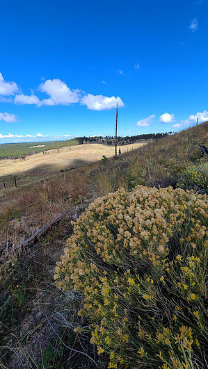
Kendrick's 8,000 foot northern bridge by joebartels  Overview OverviewConnector Trail #80 bridges the gap between Pumpkin Trail #39 to Bull Basin Trail #40. This trail is easy on the lungs, requires your attention for route-finding, and has a few washed-out areas. Prologue The recent 2017 Boundary Fire and 2000 Pumpkin Fire have left the terrain and flora in what most consider an undesirable state of torched forest. It is unlikely a target destination.
From the west, Connector Trail #80 begins 1.1-miles along Pumpkin Trail #39, up from the sedan-accessible Pumpkin Trailhead when the road is dry. Cairns help navigate the faint trail. I recommend having the Official Route loaded in your device or app of choice because the trail is difficult to follow in at least one area. The trail heads south, rising 100 feet, and contours just below 8,200 through a large ravine that leads up to Pumpkin Ridge. There are several washed-out sections the trail crosses. Most will be able to jump across the ruts but use your best judgment on what is the safest approach for yourself. Tread across one of the broader ravines is just in poor condition. Next, the trail goes back north easing around a ridge and into Bull Basin. After hiking across the upper end of the basin, it ends about 0.9-mi up Bull Basin Trail #40 at a signed junction. Synopsis A famous HAZ'r declared this the easy miles of our loop so others might look forward to it more than myself. Short Lasso Loop Pumpkin > Connector > Bull Basin > Kendrick > Pumpkin Long Lasso Loop Kendrick > Pumpkin > Connector > Bull Basin > Kendrick Check out the Official Route and Triplogs. Leave No Trace and +Add a Triplog after your hike to support this local community. One-Way Notice This hike is listed as One-Way. When hiking several trails on a single "hike", log it with a generic name that describes the hike. Then link the trails traveled, check out the example. | |||||||||||||||||||||||||||||||||||||||||||||||||||||||||||||||||||||||||||||||||||||||||||||||||||||||||||||||||||||||||||||||||||||||||||||||||||||||||||||||||||||||||||||||||||||||||||||||||||||||


