 Route Editor

| Guide | ♦ | 132 Triplogs | 3 Topics |
details | drive | permit | forecast | 🔥 route |
stats |
photos | triplogs | topics | location |
| 753 | 132 | 3 |
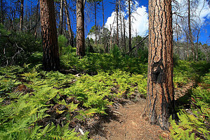
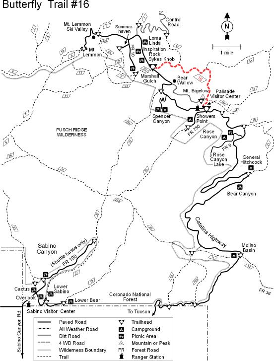
Are we there yet? by Desertboots   This delightful summer trail is best done in a two-car shuttle. Even though it is technically only 5.7 miles, it is the quality, not the quantity of the miles. You'll thank ol' Desertboots for suggesting a two-car approach! My group and I did the opposite of what is described in most of the trail books. The first time I hiked this trail, I did it the "legal" way from the actual trailhead. If you start from the Palisades Ranger Station, you will shave 200 feet of the climb out of the canyon, and being the lazy climber I am, any elevation gain avoided is okay by me. The trailhead is officially at the parking area near Soldier Camp Road, and since you will have two cars parked at either trailhead, you can begin from either place. The only word of warning is that if you start at Palisades, the trailhead is not marked. Cross the road and find the trail as it marches up the hill, and bear right. This all-uphill approach trail will lead you to a sign that guides you to the Butterfly Trail. This delightful summer trail is best done in a two-car shuttle. Even though it is technically only 5.7 miles, it is the quality, not the quantity of the miles. You'll thank ol' Desertboots for suggesting a two-car approach! My group and I did the opposite of what is described in most of the trail books. The first time I hiked this trail, I did it the "legal" way from the actual trailhead. If you start from the Palisades Ranger Station, you will shave 200 feet of the climb out of the canyon, and being the lazy climber I am, any elevation gain avoided is okay by me. The trailhead is officially at the parking area near Soldier Camp Road, and since you will have two cars parked at either trailhead, you can begin from either place. The only word of warning is that if you start at Palisades, the trailhead is not marked. Cross the road and find the trail as it marches up the hill, and bear right. This all-uphill approach trail will lead you to a sign that guides you to the Butterfly Trail.From here, you will begin a very long descent through a major burn area from the fire in 2003. Chances are, if you touch anything, you will end up sooty. There is a considerable undergrowth of plants, especially ferns. There are also many fallen snags you have to negotiate along the trail.
From here, you will walk along the creek bed, and it is a fantastic area. The creek drops significantly into a deep ravine. Then you start climbing. Climbing and climbing and climbing! There is a point where again, you can go the wrong way. When you begin switchbacking, and you come to a place where some wooden logs are hammered down to what looks like a logical step and a trail to the left, that is a faux trail. The actual trail switches to the right and continues the grueling, er, I mean, heart-rate enhancing climb up. You will finally reach a sign that indicates Catalina Highway is 1.4 miles. There are a couple of trail crossings here, but you want to go in the direction of Catalina Highway. From here, you guessed it; you keep climbing! It is a very long 1.4 miles. You will emerge onto an old jeep trail. Just keep following this, and you will reach Shangri-La, the beloved parking area with excellent restrooms. At this point, I would recommend taking the 4-mile trip to Summerhaven and visiting the Summerhaven Cafe for a bite of something good to eat and have a slice of homemade pie! Just do it before 5 pm, when the cafe closes. Much of this hamlet burned down in the fire of 2003, and there is much construction going on.
Coronado FS Details This is a wonderful trail that passes through an area of such diverse biology that part of it has been designated a Research Natural Area. Views are diverse too, facing both east and west in what is a unique situation among generally south and west-facing Santa Catalina trails. In addition, many of these attractions can be reached by hiking the first part of the trail, which is easier, and avoiding those steeper portions that account for its more difficult rating. This is the perfect trail to bring along your tree and wildflower books and something on butterflies, since these colorful creatures congregate in clusters among the wildflowers that grow here. Along the trailside, there is a wide variety of trees, including ponderosa pine, Douglas fir and Southwestern white pine in the high, cool areas; Arizona Madrone, Box Elder and Big Tooth Maple in the more moderate areas; and Alligator Juniper, various species of oak and yuccas in drier, more exposed areas. Moist ravines are decorated with Columbine and Butterfly Weed, while south facing slopes provide an appropriate habitat for prickly pear and hedgehog cactus. Views along this trail are as diverse as the biology, especially if you take the short side hike to the top of Mt. Bigelow. At this forest lookout location you'll find good views of Tucson to the west. The rest of the trail offers views to the east of Alder Canyon, the San Pedro Valley and the copper smelter at San Manuel. Attractions: Trees, wildflowers and butterflies East-west views Cool forest setting Diverse biology Easy hike option Research Natural Area Check out the Official Route and Triplogs. Leave No Trace and +Add a Triplog after your hike to support this local community. | ||||||||||||||||||||||||||||||||||||||||||||||||||||||||||||||||||||||||||||||||||||||||||||||||||||||||||||||||||||||||||||||||||||||||||||||||||||||||||||||||||||||||||||||||||||||||||||||||||||||||||||||||||


