Route Editor

| Guide | ♦ | 7 Triplogs | 0 Topics |
details | drive | no permit | forecast | route |
stats |
photos | triplogs | topics | location |
| 127 | 7 | 0 |
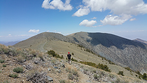
crawl out of the shadow of death by joebartels  Shuttle hike from Shorty's Well ( 253 ft below sea level ) to Telescope Peak 11,048 then down to Mahogany Campground. For reference, Shorty's Well is on the western edge of the Badwater Basin ( 282 ft below sea level ). Which is just west of the headwaters for the Amargosa River... leave ye rafts at home. Death Valley 101 The valley proper is about 40 miles in length and 8-12 miles wide east to west. To the west of this dry lake valley is the Panamint mountain range named after the Panamint Indians. To the east lies the Amargosa range with ominous peak names like Dante and Funeral.
"Shorty" Alexander Borden, a miner, dug the well that bears his name without power equipment. He built the road up Hanaupah Canyon with his burros named "Hanaupah Jack" and "Tule Hole" to access his claim. Using nothing more than a crowbar, pickax, and possibly some dynamite, he completed the road from Oct 1932 to Mar 1933. Borden mined 40 tons of ore that assayed around $24 per ton. Unfortunately, at $26+ to transport to the nearest smelter in Salt Lake City, the operation was a bust. Shorty left the ore and moved on. By the late 1930s, the title on his mine lapsed. Years later, World War II brought smelters closer as the price of lead skyrocketed. A couple of trucks drove up Shorty's hand-built road, took his ore, and cashed in on his hard labor. Shorty never received a penny. Luckily as a WWI veteran, he was able to retire in Lone Pine on his compensation. Hike The ascent at 11,240 feet is among the highest in the US. From Shorty's Well, follow the old mining road a good 8 miles up into the South Fork of Hanaupah Canyon. At 3 miles is an exciting 8-foot boulder. Creosote and brittlebush are the first signs of life around 5 miles. The road fades, and you keep heading up the wash. Just use the path of least resistance. Looking for cairns would be a waste of time. Gravel, sand, and low brush slow you down a bit. Just after 9 miles, the creek was flowing on our trip, which seemed impressive for this mineral dust bowl. Topo shows a spring another 0.6 mi up the canyon and Hanaupah Spring 0.9 mi, so it may not always flow down this far. Burros inhabit the area, so filtering the water is recommended. We crossed the creek and stayed closer to the north side until 9.4 mi. Here near the "ny" in "Canyon" on topo, we ascended to the ridge that divides Middle and South Hanaupah canyons. It's a steep 1,300 to 1,550 ascent, depending on how you do it. Left on a use-trail at 4,930 makes the top few hundred feet much easier to negotiate. According to Shorty, burros have trails up and over the other side of the range. In planning, this part looked daunting. After hiking 9 miles of hard to loose gravel, my hip rejoiced on this ascent. Intermittent faint trails along the ridge take you into scattered pines. On our cooler than average May 21st hike, I switched over to a long sleeve shirt and pants. After pines lift your spirits, scree/talus fields beat you down. These are not nail-biting rock slides like I've surfed at Grand Canyon. Rather a workout on tired legs. Perhaps burro trails skirt slightly north. Just after 14 mi, you pickup the summit trail. Statistically, it isn't a wall between 12 and 14 miles, but it sure seemed like it. We took three breaks ranging from 6 to 12 minutes in this area. We rejoiced when we came to the maintained trail to the summit. It felt like a 1.7 mi stroll. After a well-deserved break at the summit, it's 6.2 mi down to Mahogany Flat Campgrounds. Please note that this hike's upper end is often covered in snow when it's most enjoyable at the bottom. I'll guess... late Oct to early Nov & Apr is prime time for this hike. Check out the Official Route and Triplogs. Note This is a difficult hike. It would be insane to attempt this entire hike without prior experience hiking. Leave No Trace and +Add a Triplog after your hike to support this local community. | ||||||||||||||||||||||||||||||||||||||||||||||||||||||||||||||||||||||||||||||||||||||||||||||||