Route Editor

| Guide | ♦ | 12 Triplogs | 0 Topics |
details | drive | no permit | forecast | 🔥 route |
stats |
photos | triplogs | topics | location |
| 90 | 12 | 0 |
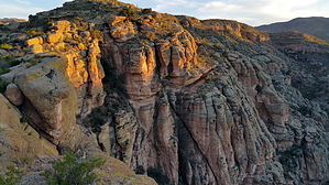
Keep the Griswold's alive! by joebartels  This mini hike from the lackluster rest stop is most scenic. Grippy smooth rock draws you out. It's similar in the grip to Papago Buttes. Here it's lathered in litchen and hosted by a crumbly base. This mini hike from the lackluster rest stop is most scenic. Grippy smooth rock draws you out. It's similar in the grip to Papago Buttes. Here it's lathered in litchen and hosted by a crumbly base.This was my second trip, and by chance, I wore sandals again. They work, but the stability of a shoe would be more welcome.
It screams to be the perfect jaunt for Apache Trail tourists, families, or the perfect date hike. The above categories will probably be satisfied with under a mile round trip. The further you go, the dicer it gets, so keep the Griswold's alive. Two miles out-n-back should cover the entire overlook. From the parking lot, follow the sidewalk until it ends. It's an arbitrary off-trail adventure continuing. Be careful as it is potentially dangerous and deadly. Check out the Official Route and Triplogs. Leave No Trace and +Add a Triplog after your hike to support this local community. | |||||||||||||||||||||||||||||||||||||||||||||||||||||||||||||||||||||||||||||||||||||||||||||||||||||||||||||||||||||||||||||||||||||||||||||||||||||||||||||||||||||||||||||||||||