Route Editor

| Guide | ♦ | 2 Triplogs | 0 Topics |
details | drive | no permit | forecast | route |
stats |
photos | triplogs | topics | location |
| 83 | 2 | 0 |
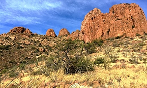
Tubac Secret Revealed! by AZHiker456  After living in Tubac for almost three years and growing increasingly frustrated with the lack of "trail" data in my area, I decided that enough was enough. I finally felt experienced enough to get creative and go off the beaten path, literally! Last December, with a small group of friends and hardcore hikers from local clubs, I had done one of the Devil's Cashbox Peaks, Tumacacori Peak, and San Cayetano Peak [none of which have descriptions on HAZ either]. All were classic, Southern Arizona style bushwhacks, filled with almost every variety of cactus and thorny shrub that AZ has to offer, [or so it seemed]; and all were adventures to remember, all ranking among my most challenging bushwhacks. After living in Tubac for almost three years and growing increasingly frustrated with the lack of "trail" data in my area, I decided that enough was enough. I finally felt experienced enough to get creative and go off the beaten path, literally! Last December, with a small group of friends and hardcore hikers from local clubs, I had done one of the Devil's Cashbox Peaks, Tumacacori Peak, and San Cayetano Peak [none of which have descriptions on HAZ either]. All were classic, Southern Arizona style bushwhacks, filled with almost every variety of cactus and thorny shrub that AZ has to offer, [or so it seemed]; and all were adventures to remember, all ranking among my most challenging bushwhacks.Like the peaks mentioned above, Diablo Mountain did not disappoint! I would rank it much easier in terms of the bushwhacking aspect – relative to the other three. This is not to say it was a walk through the park; rather, the quantity and number of cacti / thorny shrubs were a lot less, and the footing a bit better. In terms of the views, however, Diablo Mountain takes the prize! The panoramic views are amazing, to say the least.
There were many faint routes throughout the journey, some of which resembled game trails and others that looked more like animals had blazed them. It helped to have some sort of route to follow. After around nine-tenths of a mile, I reached the base of a rock outcropping decided to head to the left [had I gone right and cliffed out, it would've been a big backtrack; but had I cliffed out at the saddle area – which proved to be the case – it was under 5 minutes of backtracking altogether]. The saddle's views were quite lovely, and oddly enough, [not having seen cairns the whole way], there was a giant cairn in the saddle area. As I turned to backtrack, I noticed a nice route leading around the other side of the rock outcropping, so I hopped on it. After getting around the outcropping, the route continued upward and then headed straight in between a short, shaded gulley with a small tree in the middle of it. I should've remembered to create a waypoint, but if you have any kind of route-finding skills, it should be pretty obvious. :) After going up the small gulley [which has surprisingly good footing], the hike's finale proved to be both a teaser and a pleasant surprise. From what I could see of Diablo Mountain as I was approaching, I knew that the high point – as seen from the gulley – would prove to be a false summit. The pleasant surprise and thing I was not expecting: upon emerging from the gulley and making it to the first high point, I literally popped out on a sweet ridgeline! At this point, you are pretty much home-free: the path of least resistance is pretty obvious, and the route is relatively well defined from here on out. The teaser is that the ridgeline seems to keep going and going. I always run two GPS apps, [so sometimes I mix the numbers up!], but if I remember correctly / I had to estimate, the ridgeline portion of the hike is about four-tenths of a mile. I am NOT the kind of hiker that counts things like # of switchbacks or false summits, […that kind of thing would drive me nuts!], but even after reaching the ridgeline, there were a good number of false summits before I arrived at the peak. It was a very fun ridgeline to traverse and a definite teaser, to say the least. Once you've reached the highest peak on the ridgeline, head for what looks to be the highest point on that peak, and you'll find a marker. It says 'United States Army' across the top; and, [in letters almost as big], 'Fort Sam Houston Texas' at the bottom. Right near the marker under a small pile of rocks is the summit register. To say this peak doesn't get a lot of action would be an understatement! Nonetheless, I was still surprised to see other small groups of 2-5 people over the years – not counting the SAHC groups, [since this is a SAHC peak, I knew it would have some names in the log]. I decided to take a chance and go a slightly different route down for the return trip, veering from my track up shortly after descending the short gulley at the southern end of the ridgeline. In addition to noticing a nice route [southeast relative to my track on the ascent], it also looked to be a more direct route back to my vehicle. Being able to view the many beautiful rock outcroppings on the southeastern face of the mountain definitely made the choice better in terms of scenery. Terrain / difficulty-wise, it ended up being about the same, [maybe slightly easier if I had to guess]. Check out the Official Route and Triplogs. Leave No Trace and +Add a Triplog after your hike to support this local community. | |||||||||||||||||||||||||||||||||||||||||||||||||||||||||||||||||||||||||||||||