Route Editor

| Guide | ♦ | 2 Triplogs | 0 Topics |
details | drive | permit | forecast | route |
stats |
photos | triplogs | topics | location |
| 26 | 2 | 0 |
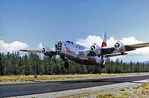
Treat with Respect by rvcarter  Background BackgroundSome history is needed to describe this hike. The crash site that is the destination involved a large plane with a fascinating history. It rolled off the Boeing assembly line as a B-24 in 1944, destined for use in World War II. Somewhere along the line, it became the property of the Department of Navy and became known as a Navy Privateer PB4Y2. It saw combat duty toward the end of the war in the Pacific theater with VPB-111 (apparently a squadron designation). In 1956, George Stell bought the plane and converted it for duty as an air tanker for fighting forest fires. Now in civilian status, the plane was categorized as a C-50 with registration # N7237C. I’ve included a picture of the plane taken in 1972. It has the dubious distinction of being the only known aircraft to go down in Arizona, where the plane saw combat duty during WWII. The pilots were a father and son team, George and Greg Stell. The retardant-heavy aircraft was fighting a forest fire (the so-called Lindsey Fire) near Safford, AZ, on June 27, 1974, when one of the wings caught a tree during a slurry drop and crashed. Unfortunately, both Stells were killed in the horrific crash. The result was an unfortunate loss to the aerial firefighting community of a skilled pilot and his 20-something son (Greg was flying at the time of the crash). The plane crashed down an unnamed ridgeline, spreading parts for hundreds of yards along the flight path. The debris field, which is visible at 12S 588662, 3620664 on Google Earth, remains largely undisturbed on land managed by the USFS southwest of West Peak. About 25 feet of tail section and control surfaces and outer wing panels remain the most recognizable pieces. The debris field is huge, with one wing visible up the slope (at 12S 588775, 3620744) about 375 feet from the tail section. It's not likely that the pieces will be removed anytime soon as USFS sees it as a memorial to aerial firefighters killed in the line of duty. Another, probably more practical reason is that the size and weight of many of the items remaining on the hillside are too heavy and expensive to move.
Getting to the crash site involves some perseverance and effort. The author has post three tracks to help, including one showing the road in from US Hwy 70 (Tripp Canyon Road, # 286) near Pima, AZ, and the recommended hike route to the crash site. Also included is my entire track. There is an excellent overall map showing other features in the area (courtesy of HAZ member “Kingsnake”). The drive from US Hwy 70 to where we parked is 26 miles, all dirt/gravel, but manageable with a high clearance 2WD vehicle. There is a nice parking spot at the lower entry point for the Blue Jay Ridge Trail loop at about 7600 feet (near Turkey Spring). It is at this point that most people will start hiking (roughly 12S 589958, 3623332). One could drive to the top of West Peak, but the road gets a lot steeper after this and could be problematic in anything less than a 4WD vehicle, especially in wet weather. The Hike To get to the crash site, walk up the road to the saddle near the West Peak tower and hike southwest on the Sky Islands Traverse Trail (this is the trail name on Google Earth, it’s called Hurricane Pass Trail on some maps). This portion of the trail overlaps for about ¾ miles with the Grand Enchantment Trail Segment #10 – Pinaleno Mountains. Without an actual track to follow, it looks like the best route is down the ridge all the way. However, this will soon cliff out, and you’ll be scrambling down to the left. (Oddly enough, the only time you see wreckage is from the top of this cliff. Wreckage is not visible on the recommended, faint trail until you’re right on top of it.) The best route is to stay somewhat on the left (east) side of the ridge and follow a faint but fairly easy-to-follow trail out to the site. Look for a few cairns and some ribbon along the way. Resist the lure of dropping to the left too soon. When in doubt, return to the ridge and continue southwest. My full track shows the out and back, but I highly recommend using the return route to navigate. I intend to reverse this portion of my tract for posting as the official track. You’ll feel like you’re bushwhacking in some spots, and there is some scrambling but nothing above a mild class 3. The RT distance and aeg from the West Peak saddle to the site are small (3.4 miles and under 1300 feet), but it feels like more. This is a unique destination where a real-life tragedy took place. Please treat the area with the respect it deserves. Take time to view and reflect, then retrace your steps. I was there... Bill e-mailed HAZ: I was one of the helitack crewmen who was on the initial attack of this fire. It was a lightning strike. A B17 slurry bomber was also dropping slurry. I casually knew the pilots because they were based out of Tucson International airport where our Huey helicopter was also based. Referenced in Alaska, Bent Props And Luck by Bill Mader Check out the Official Route and Triplogs. Leave No Trace and +Add a Triplog after your hike to support this local community. | ||||||||||||||||||||||||||||||||||||||||||||||||||||||||||||||||||||||||||||||||||||||||||||