 Route Editor

| Guide | ♦ | 17 Triplogs | 0 Topics |
details | drive | permit | forecast | 🔥 route |
stats |
photos | triplogs | topics | location |
| 30 | 17 | 0 |
reverse false summit effect by AZHiker456   Note NoteThe Nogales Ranger district states cross country travel in a wilderness should be wild and challenging. Please do not cut brush, trees, vegetation nor clear or mark a route. Prologue Sitting at 8,478', this large Santa Rita peak doesn't get much attention. However, it's a fun little scramble with beautiful views and definitely something to consider, especially if you live in the area and have done Mt. Wrightson and Mt. Hopkins and are ready for something new.
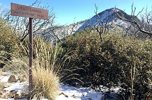
As you enter Madera Canyon, there will be several trailheads. The one you want is all the way at the top [as far up as you can drive]. It's paved the whole way. Hike Take the Old Baldy Trail to Josephine Saddle. At Josephine Saddle, you'll need to jump on the [upper] Super Trail, which circles Mt. Wrightson in a counterclockwise direction. NOTE: You'll want to really pay attention once reaching Josephine Saddle, which has been dubbed, 'The Crossroads of the Santa Ritas', [and rightfully so, as 7 trails intersect here]. My GPS track should help eliminate a lot of confusion and ensure that you're on the right trail; however, [despite having been by Josephine Saddle 30+ times], even I jumped on the wrong trail and ended up down the scenic Temporal Gulch Trail, which parallels the upper Super Trail in the beginning. Thus, if using my GPS track to guide your way, you'll want to go LEFT when you see my track split. After bagging Josephine Peak, I came down the entire way from Riley Saddle to Josephine Saddle via the Super Trail, so relative to your ascent, this is LEFT-HAND track when my track splits. If you're up for a little off-trail warm-up, then feel to follow the right-hand track as I did during my ascent; it will take you down the Temporal Gulch Trail, past McBeth Spring, and soon after that on a 100% off-trail "elevator ride" back up to the Super Trail. Once you arrive at Riley Saddle, [however that may be…], the real fun begins. Riley Saddle is signed, and so is Josephine Peak. You can't miss either. To my surprise, there is a fairly well-defined route from Riley Saddle to Josephine Peak. That said, it's a burned area and things can get pretty overgrown at times so there will be moments that feel like a full out bushwhack [but only moments; most of the route is very pleasant, bush-wise]. A further note about the route: there were many inches of snow when I bagged this peak, so there are likely times when my GPS tracks do not follow the path of least resistance. However, for the most part, they are pretty close. Someone had actually done this peak very recently, and their footsteps definitely seemed to be following a better path than mine. Soon after I started following the footprints, I starting seeing cairns; a definite sign that they were leading me to where I wanted to be. Even in the snow with some slippery spots, things never got too difficult. A few hiking acquaintances that attempted this peak about a year ago reported it to be 'an extremely gnarly bushwhack' [because it goes through a burned area]. However, aside from a handful of brushy spots, I did not find the undergrowth to be bad at all. That said, there was one particularly shrub that will likely put holes in your skin if you decide to do this in shorts; however, [minus a few thorns that were very low on the pain scale and pulled right out of the skin], I fared just fine in pants. I have yet to experience a 'gnarly bushwhack' at over 7,000'. I also heard a few reports of people getting cliffed out while attempting this peak. While I found it especially easy [with the 'magic' footprints that lead straight to the peak], I could definitely see how cliffing out might happen if the snow is deep enough to completely cover the route and/or you attempt this without having a GPS track. Finally, in terms of the summit, this was one of the very few times where I've experienced the lovely, 'reverse false summit effect,' [where you're almost willing to bet your life there's going to be a false summit and for once it turns out to be the peak you're trying to bag]. Toward the final push, things get very steep; to the point where all you can see is the 'horizon line' right in front of you. After summiting so many peaks where you push to reach that horizon line, [only to find it was a false summit], Josephine Peak is one of the nice few where that final steep push really proves to be the true summit. The views from on top are like the views from most of the big peaks in the Santa Ritas: just awesome! I particularly enjoyed the view of Mt. Wrightson. It's definitely not your everyday view of this peak! The summit log for Josephine Peak is in good condition and located right by the high point, [which is obvious thanks to a tall wooden post]. The signatures go back to 2006. Check out the Official Route and Triplogs. Leave No Trace and +Add a Triplog after your hike to support this local community. | |||||||||||||||||||||||||||||||||||||||||||||||||||||||||||||||||||||||||||||||||||||||||||||||||||||||||||||||||||||||||||||||||||||||||||||||||||||||||||||||||||||||||||||||||||||||||||||||||||||||||||


