Route Editor

| Guide | ♦ | 7 Triplogs | 0 Topics |
details | drive | permit | forecast | 🔥 route |
stats |
photos | triplogs | topics | location |
| 66 | 7 | 0 |
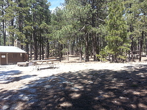
One Looong Trail by Mountain_Rat   Prologue PrologueYou are reading this right now because I could not hike and instead decided to reminisce while trapped at home. On March, 27 of 2013, I made this trek as it would be best done early spring or fall, giving max daylight with mild conditions for a 26 mile / 6,300’ hike. Hike This adventure begins at the Douglas Spring trailhead, at the east end of Speedway Blvd n Tucson’s far east side. From the parking area, you head predominantly east, with a slight drift to the south. In the first 6.5 miles, you gain a mere 2,200’ as you transition through various venues of middle desert before arriving at the Douglas Spring campground. This is a rather small campground with only three campsites as far as I can tell. It does, however, boast the finest outhouse in all the Rincon campgrounds and a hitching post. On the south edge of the campground, the Douglas Camp Spring can often be found. Though I have seen attainable water here each time I’ve passed, I understand that this spring is considered dry by the forest service and should not be considered a dependable water source.
The next checkpoint is the intersection with the Cow Head Saddle trail, and you will have put on another 1,450’ of gain getting here. Again you push eastward and again climb steadily. To me, this seems to be the toughest part of the hike, though statistically, it’s a touch lighter than the climb up the ravine. I guess it’s a mental thing. At any rate, shortly after you begin the Cow Head section, you start coming into pine. The views here aren’t the greatest, but that kind of lends to a feeling beyond solitude and more like isolation. You will have come 3.5 miles and gained 2,100’ more AEG along the Cow Head when you top out for the day. Now all that’s left is to drop down into Manning Camp, about 6/10 miles all downhill, and enjoy the atmosphere. There are also a number of side excursions in the area if time, weather, and water allow; Mica Mountain, Spud Rock, Reef Rock, Devils Bathtub, are all nearby. Just be safe, and we’ll leave the light on for ya...
Check out the Official Route and Triplogs. Note This is a moderately difficult hike. Leave No Trace and +Add a Triplog after your hike to support this local community. | ||||||||||||||||||||||||||||||||||||||||||||||||||||||||||||||||||||||||||||||||||||||||||||||||||||