Route Editor

| Guide | ♦ | 16 Triplogs | 0 Topics |
details | drive | permit | forecast | route |
stats |
photos | triplogs | topics | location |
| 360 | 16 | 0 |
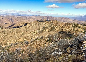
Atascosa Lookout does NOT sit on Atascosa Peak! by AZHiker456   I hate to break it to you folks, but [just like Tucson’s Window Rock & Window Peak are NOT the same], neither are Atascosa Lookout & Atascosa Peak. It’s amazing how many experienced hikers think they’ve bagged Atascosa Peak; when in fact, they’ve only made it to the Lookout. I’m guilty of it too… I bagged the Lookout twice and just assumed I’d also bagged Atascosa Peak. I hadn’t. If you don’t read the Atascosa Lookout hike's description carefully enough [or aren’t already aware of it], it’s very easy to miss the peak. After all, the Atascosa Lookout Tower does sit on a peak, just not Atascosa Peak. I hate to break it to you folks, but [just like Tucson’s Window Rock & Window Peak are NOT the same], neither are Atascosa Lookout & Atascosa Peak. It’s amazing how many experienced hikers think they’ve bagged Atascosa Peak; when in fact, they’ve only made it to the Lookout. I’m guilty of it too… I bagged the Lookout twice and just assumed I’d also bagged Atascosa Peak. I hadn’t. If you don’t read the Atascosa Lookout hike's description carefully enough [or aren’t already aware of it], it’s very easy to miss the peak. After all, the Atascosa Lookout Tower does sit on a peak, just not Atascosa Peak.I’ll spare the detail about the Atascosa Lookout Tower's history since that hike is already written up. Bottom line: to reach Atascosa Peak, you must continue 1.5 miles North of Peak 6249, [which is the peak where the remains of the Atascosa Lookout Tower sit].
After reaching the Lookout Tower via the Atascosa Lookout Trail #100, head toward the small summit's northeast side, and a route should become visible. I don’t recall if cairns were marking the route, but you need to head downward toward the ridgeline that runs between Peak 6249/the Lookout Tower and Atascosa Peak, the big peak to the North that, [to me], somewhat resembles a bell. The ridgeline is tons of fun for those that enjoy bouldering hopping, and the scenery is spectacular. If you think the views from the Lookout Tower are fantastic, then you’re in for a real treat; they keep getting better as you approach Atascosa Peak. The peak can look intimidating from a distance, and I thought I’d be in for a tiring climb after the ridgeline section. It was a pleasant surprise to find that nearly the whole way from Atascosa Lookout to Atascosa Peak was almost exclusively boulder hopping fun – we’re talking huge, solid, excellent gripping rocks and virtually no brush. The sensational views throughout were like icing on the cake! There is a HUGE cairn on the highpoint, and the summit register is under some rocks toward the top of the cairn. While the views are awe-inspiring from the highpoint, I found them to be even better from a sweet viewpoint toward the Northern edge of the summit. To reach this beautiful viewpoint, continue past the highpoint, heading mostly north and slightly to the East. There is a faint route initially and some light brush, but keep heading downward. About 2-5 minutes past the highpoint, you will arrive at the summit’s edge and be treated to exceptional views, unobstructed by brush, that overlooks the beautiful Ramanote Canyon. There is a massive boulder at the edge, and it makes for a great resting spot while taking in the views. After enjoying the summit, return by the same route. Check out the Official Route and Triplogs. Leave No Trace and +Add a Triplog after your hike to support this local community. | ||||||||||||||||||||||||||||||||||||||||||||||||||||||||||||||||||||||||||||||||||||||||||||