Route Editor

| Guide | ♦ | 2 Triplogs | 0 Topics |
details | drive | permit | forecast | 🔥 route |
stats |
photos | triplogs | topics | location |
| 36 | 2 | 0 |
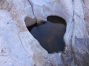
Unique Views by rvcarter  Background BackgroundSometimes the planning for our hikes gets started during drives down Oracle Road to a hike or climb. The passengers will look at the plethora of peaks located on the west side of the Santa Catalina Mountains and say “look at that peak over there, I wonder if anyone has climbed that one?” In full disclosure, that process was the inspiration for climbing “Frank’s Rock” (Peak 5110 south of Romero Pools), “Buster plus” (Peak 5058 east of Buster Mountain), Bighorn Northwest Approach, and “Golder Dome” (Peak 4710 southwest of Cargodera Spring). Now, in the deep recesses of our little brains, we’ve begun the process of attempting to summit the numbered peaks between the Sutherland and Romero Canyon Trails. The current focus is an unnamed peak with a very distinctive (almost thimble-like) crag at the top. The peak has no marked elevation on my somewhat dated USGS quad map, but on some maps, it’s marked as 6001 feet. Recently, we took a 2nd reconnaissance hike to explore the best way to get there. The goal of this trip was to reach Peak 5430, which is located about ½ mile southwest and 800 feet below Peak 6001, and it was so impressive I decided to describe it as a unique hike (stay tuned for the description for Peak 6001, if and when we get there). Hike Park at the easternmost parking lot at Catalina State Park and head up the Romero Canyon Trail. Shortly before reaching Romero Pools, drop left into Romero Canyon and find a prominent unnamed canyon to the northeast. You have to get out of the canyon at a few points to avoid the water pools, but with some boulder hopping and scrambling you can stay in the canyon for a long time. It’s a beautiful canyon with lots of slick rock and pools from the recent snow; however, nothing above middle-class 3. Lots of photo ops in here, so take your time and enjoy. I doubt you will see another soul, human that is, in this canyon.
At the saddle, you finally see how everything relates spatially. Peak 6001 is to the NE, Golder Dome is to the NW, the peaks mentioned above are to the south, and Peak 5430 is visible to the SW. Rest some here because you still have some scrambling left to get over there. As you get close, the going gets pretty hard and slow. Some climbing experience is useful here. Just keep looking for openings and good footing/handholds. When you make it, celebrate, and sign in at the canister Frank and I left on top. Enjoy the special views you have from this peak. The way we took back down was shorter and ok, and free from thorny plants, for the most part. The objective is to drop into the canyon you came up in and retrace your steps to the trailhead at CSP. If you like beautiful streams, unique views, and solitude, you will love this loop off the Romero Canyon Trail. Note the route more than 400 feet off the Romero Canyon Trail is off-limits from January 1 to April 30 of each year because of the Bighorn Sheep Re-introduction Project. Dogs are never allowed past the lower canyon for the same reason. Check out the Official Route and Triplogs. Note This is a moderately difficult hike. Leave No Trace and +Add a Triplog after your hike to support this local community. | |||||||||||||||||||||||||||||||||||||||||||||||||||||||||||||||||||||||||||||||||||||||||||||||||||||||||||||||||||||||||||