username
X
password
register
for free!
help
 This is likely a great time to hike this trail!  Check out "Preferred" months below, keep in mind this is an estimate. 
   🔥

Marshall Peak - Santa Catalinas, AZ

Guide 3 Triplogs  0 Topics
  2 of 5  
Fav
Wish
0
details
drive
permit
forecast
🔥
route  
stats
photos
triplogs
topics
location
0 3 0
Statistics
tap row or icons for details
Difficulty 2.5 of 5
Distance Loop 3.86 miles
Trailhead Elevation 7,437 feet
Elevation Gain 868 feet
Accumulated Gain 1,037 feet
Kokopelli Seeds 9.05
 Interest Off-Trail Hiking & Peak
unreported if dogs are allowed
editedit > ops > dogs to adjust
feature photo
Photos Viewed All MineFollowing
Will recalculate on button tap!
6  2016-06-05
Catalina Pathetica
AZHiker456
15  2016-05-07
Loopy Lemmon
chumley
Author
author avatar Guides 16,843
Routes 17,472
Photos 24
Trips 1 map ( 6 miles )
Age 28 Male Gender
Location HAZ, TrailDEX
Associated Areas
list map done
Tucson Region
Historical Weather
Trailhead Forecast
Radar Map
Expand Map
Preferred Aug, Sep, Jul, Jun
Sun  6:00am - 6:43pm
Official Route
 
3 Alternative
 
Historic Fire Perimetersacres
🔥 2020 Bighorn Fire119.5k
🔥 2003 Aspen Fire87.7 mi*
🔥 2002 Bullock46.8 mi*
🔥 View (All) - over Official Route 🔥
*perimeter length in miles


remove free decal offer

 Likely In-Season! 
Guide Needed
Publish Full Detail Guide


Use +Add above to share photos and triplogs
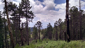
Somewhere between 8280 and 8305 feet, depending on topographic source. SP has it as the #3 peak in the Catalinas, PB has it #6.


    Check out the Official Route and Triplogs.
    Leave No Trace and +Add a Triplog after your hike to support this local community.
    WARNING! Hiking and outdoor related sports can be dangerous. Be responsible and prepare for the trip. Study the area you are entering and plan accordingly. Dress for the current and unexpected weather changes. Take plenty of water. Never go alone. Make an itinerary with your plan(s), route(s), destination(s) and expected return time. Give your itinerary to trusted family and/or friends.

     Permit $$
    no fees or permits reported

    if incorrect tell us about it

    Coronado Forest
    MVUMs are rarely necessary to review unless mentioned in the description or directions
    Coronado Motor Vehicle Use Maps (MVUMs)


     Directions
    or
     Road
    Connector trail - Not Applicable

    To hike
    page created by chumley on May 09 2016 6:36 pm
     90+° 8am - 6pm kills
    helpcorrectionissue

    end of page marker