Route Editor

| Guide | ♦ | 268 Triplogs | 0 Topics |
details | drive | no permit | forecast | route |
stats |
photos | triplogs | topics | location |
| 157 | 268 | 0 |
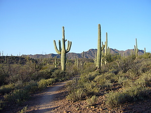
Keep your Arms In by leadhiker  2023 2023Converted to a Network of trails 2009 Guide for a Loop On June 29, 2004, Pima County announced the purchase of, and permanent protection of 700 acres in the Tucson Mountains as part of the Sweetwater Preserve. The property was the largest tract of undeveloped land in the Tucson Mountains. The open space preserve took its name from the Sweetwater Wash, a major watershed and riparian corridor, which flows through it. With the entire diverse Sonoran Desert habitat, this would be a great place to just come out and enjoy the desert. The Sweetwater Preserve should not be confused with the Sweetwater Trail in Saguaro National Park. The Sweetwater Trail is 1.5 miles west of the preserve boundary.
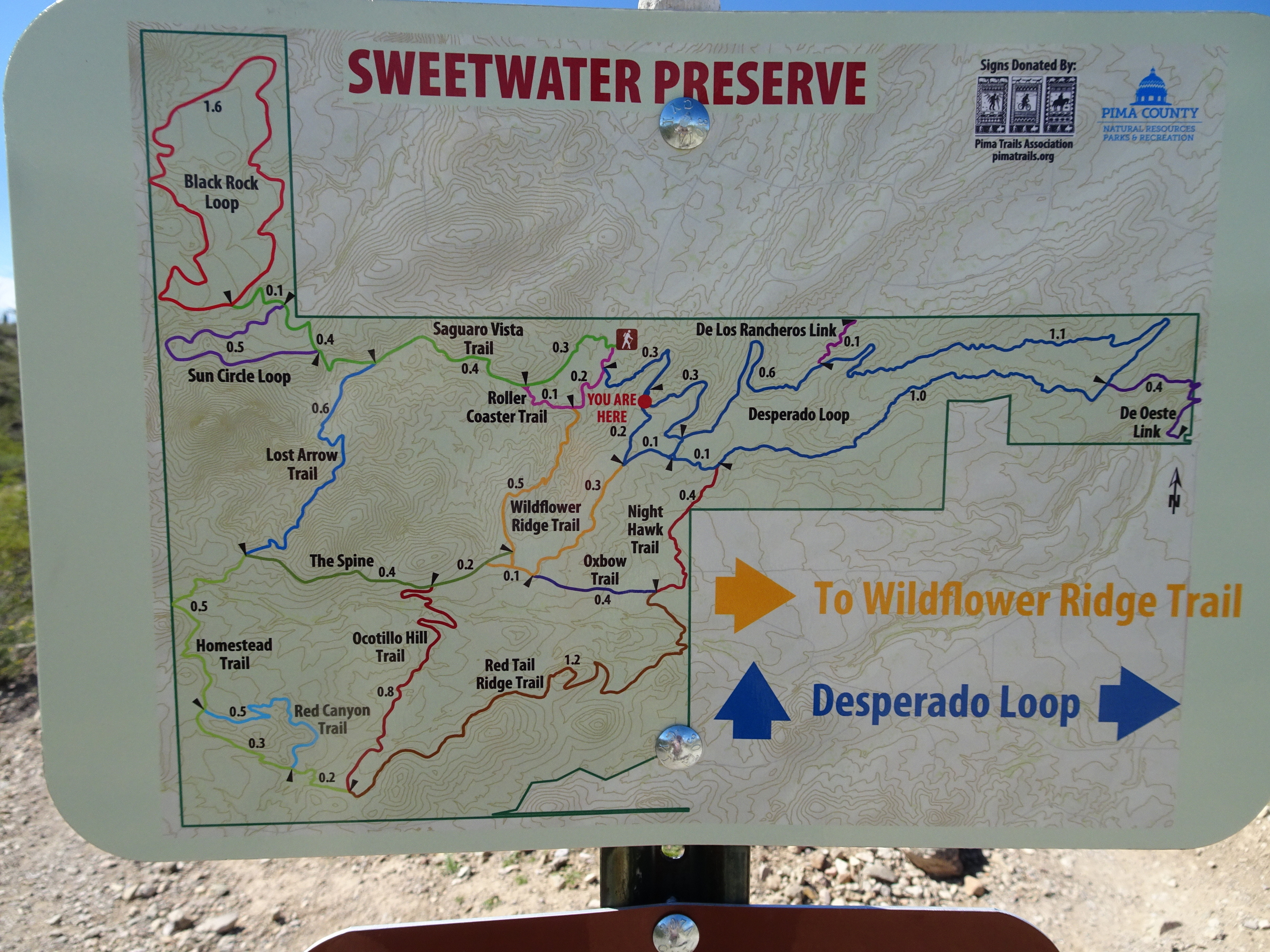
The trail system consists of 12 separate trails that interconnect. Each trail is anywhere from 0.5 to 1.6 miles in length. You can connect them to make all sorts of loops. The trails are used by mountain bikers, horseback riders, and day-use hikers. None of the trails are signed, so it would be a good idea to get a map before heading out. The Pima County Department of Natural Resources had a very good map that has the trails color-coded. Hike: I decided to hike the trails that make up the outer perimeter of the preserve and leave the inter trails for another time. From the parking lot, I started west on the Saguaro Vista Trail. This section of trail has the most extensive sections of Saguaros I have ever seen. There is even a cristate, or crested, Saguaro only 0.5 miles from the trailhead. After 0.75 miles the Sun Circle Loop Trail takes a left turn off the main trail and re-joins the trail after 0.6 miles. Turn left and continue 0.15 miles to the Black Rock Loop. This 1.5-mile loop brings you back to the Saguaro Vista Trail. Follow the Saguaro Vista Trail back 0.4 miles to the Lost Arrow Trail. Turning south on the Lost Arrow Trail, after about 4 to 5 minutes of hiking, look for a giant Saguaro on the right side of the trail. Look closely at this Saguaro and you will find an arrow stuck in the main trunk about 20 feet off the ground. The Lost Arrow Trail has about 155 feet of ascent in 0.6 miles. The most of any section of the loop. After a total of 4.0 miles, you will come to "The Spine", an old road that can take you back to the parking lot. Continue south on the Homestead Trail 0.5 miles, turning left on the Red Canyon Trail for another 0.5 miles, back to the Homestead Trail. After 0.2 miles you come to a wide place in the trail with a cross trail. This is the Ocotillo Trail and has an entrance from Sweetwater Road. There is no public parking along Sweetwater Road. Head east on the Red Ridge Trail. This section of the trail has excellent views of the city. The trail heads down and crosses the major wash along the eastern boundary of the preserve. After 1.3 miles you come up out of the wash and connect with the Oxbow Trail. Turn left here on the Oxbow Trail and continue 0.3 miles to the Wildflower Ridge Trail. The Wildflower Ridge Trail heads north for 0.5 miles before connecting with the Roller Coaster Trail for 0.2 miles back to the parking lot. The entire loop is 7.36 miles with only 536 feet of total ascent. I found that each trail within the preserve has a separate appeal.
Check out the Official Route and Triplogs. Leave No Trace and +Add a Triplog after your hike to support this local community. | ||||||||||||||||||||||||||||||||||||||||||||||||||||||||||||||||||||||||||||||||||