Route Editor

| Guide | ♦ | 13 Triplogs | 0 Topics |
details | drive | permit | forecast | route |
stats |
photos | triplogs | topics | location |
| 53 | 13 | 0 |
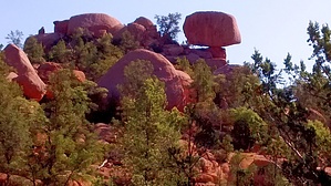
One of Payson's Best by donqcryer   Sedona has its well-known Red Rocks, but few know how beautiful Payson's Pink Rocks can be. Stewart's Pocket area may very well rival Sedona for its scenic beauty. Flanked by Stewart Ridge on the South and the Mogollon Rim on the north, it not only contains the unique boulder formations of Granite Dells but numerous peaks or knolls, many topped by pink rocks. Sedona has its well-known Red Rocks, but few know how beautiful Payson's Pink Rocks can be. Stewart's Pocket area may very well rival Sedona for its scenic beauty. Flanked by Stewart Ridge on the South and the Mogollon Rim on the north, it not only contains the unique boulder formations of Granite Dells but numerous peaks or knolls, many topped by pink rocks.Hike This lasso loop hike on the south side of Stewart Pocket / Granite Dells may be another one of Payson's best hikes. Going counter-clockwise on the loop portion, this loop initially uses Stewart Pocket - South Loop trail that climbs steeply 1/2 way up Stewart Ridge and then meanders along the grade in and out of the cool forest and rock formations. The views north of the Dells, knolls, and Mogollon Rim are fabulous!
History This trail was beautifully laid out and constructed by Payson's forest mountain bike gnomes. Unfortunately, they are a bit protective of the trail and try to keep the intersections with the SP S trail hidden (like they tried to do with that loop before many hikers discovered that loop...) Shame - this loop extension is too beautiful and so well constructed and laid out. Everyone should enjoy and appreciate the gnomes' efforts! Water Sources seasonal small flows Camping National Forest land Check out the Official Route and Triplogs. Leave No Trace and +Add a Triplog after your hike to support this local community. | |||||||||||||||||||||||||||||||||||||||||||||||||||||||||||||||||||||||||||||||||||||||||||||||||||||||||||||||||||||||||||||||||||||||||||||||||||||||||||||||||||||||||||||||||||||||||||||||||