Route Editor

| Guide | ♦ | 7 Triplogs | 0 Topics |
details | drive | permit | forecast | route |
stats |
photos | triplogs | topics | location |
| 133 | 7 | 0 |
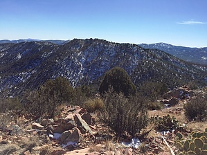
Here Kitty Kitty by Peter_Medal   Bear Down Mountain (6962') is one of three high summits of the northeasternmost grouping of the Bradshaw Mountain Ranges. From Interstate 17, taking the turn westbound onto Highway 69 the mountain range you see towards Prescott is Big Bug Mesa (on the left); then Mount Elliott (6980'); to the right is Bear Down Mountain followed by its evil arch-rival, Sun Devil Peak. These mountains pack a punch with lots of elevation gain. The range is bounded by Diamond Valley and Prescott Valley on the north; Dewey-Humboldt to the east; Mayer to the southeast; Breezy Pines & Poland Road to the south; and the Walker valley/Lynx Lake to the west. Bear Down Mountain (6962') is one of three high summits of the northeasternmost grouping of the Bradshaw Mountain Ranges. From Interstate 17, taking the turn westbound onto Highway 69 the mountain range you see towards Prescott is Big Bug Mesa (on the left); then Mount Elliott (6980'); to the right is Bear Down Mountain followed by its evil arch-rival, Sun Devil Peak. These mountains pack a punch with lots of elevation gain. The range is bounded by Diamond Valley and Prescott Valley on the north; Dewey-Humboldt to the east; Mayer to the southeast; Breezy Pines & Poland Road to the south; and the Walker valley/Lynx Lake to the west.Sun Devil Peak is shaped almost exactly like a pitchfork, hence its most logical name. Its evil rival mountain to its south, but higher in elevation, only fitting be named "Bear Down". For peak bagging, it's kind of a "bear" to get to. Access to Bear Down Mountain is serviced by two very well-groomed trails. From the northwest: Salida Gulch Trail #95 passes beneath the summit ridge from the northwest to the southeast. Charcoal Gulch Trail #9419 flanks the east face of the mountain north to south. Salida Gulch terminates at Charcoal Gulch. There is no trail to the summit. Bear Down would be an ideal add-on for peak baggers looking to connect two peaks for an ultra-day hike.
Trailhead is from the Prescott National Forest's Newtown Trailhead. This is the official trailhead for Charcoal Gulch Trail #9419. From the TH continue west on Charcoal Gulch Trail #9419 for just under 1 mile when it goes down into "Green Gulch" the major east flowing drainage for the area. Numerous side trails terminate into fire-ringed camp areas. After Green Gulch, for the next 1.5 miles, the Charcoal Gulch trail cuts through the lower elevations; ridgelines, and drainages of Sun Devil Peak. For this stretch, there is not much shade and is predominately high desert, not suggested in late spring through the end of summer. Memories of Beamer Trail in the Grand Canyon of the 5 times you sink into and back out and up the drainages of these low ridges off Sun Devil. Finally, it crosses over the Charcoal Gulch crossing (Charcoal Spring is about 1/4 mile WNW from here) at an elevation of 5908'. From the Gulch all the way to just before the summit ridgeline, the next 1.2 miles will be in a well-shaded pine and oak forest. Once approaching the Bear Down ridgeline, Charcoal Gulch trail junctions with the Salida Gulch Trail #95. Here you will find a gravesite of three dogs (6611' elevation). Salida Gulch essentially rides the ridgeline on Bear Down's southwestern face. Take Salida Gulch Trail for just over a 1/2 mile then veer right off the trail at 6696' elevation and make the boulder hop, rock climb, scramble for its peak ridgeline. Leaving Salida Gulch will be just over a 1/2 mile to the summit. Its true summit is its westernmost (third) prominent outcropping. Unlike Sun Devil Peak which is peppered with numerous fire rings on its summit ridge, Bear Down had none. You will find a HAZ summit register nestled in the crack of its true summit. Check out the Official Route and Triplogs. Leave No Trace and +Add a Triplog after your hike to support this local community. | |||||||||||||||||||||||||||||||||||||||||||||||||||||||||||||||||||||||||||||||||||||||||||||||||||||||||||||||||||||||||||||||||||||||||||||||||||||||||||||||||||||||||||||||