username
X
password
register
for free!
help
  This is likely a great time to hike this trail!  Check out "Preferred" months below, keep in mind this is an estimate.
  

Charcoal Gulch Trail #9419, AZ

Guide 13 Triplogs  1 Topic
  3.2 of 5  
Fav
Wish
1
details
drive
permit
forecast
route  
stats
photos
triplogs
topic
location
227 13 1
Statistics
tap row or icons for details
Difficulty 3 of 5
Distance One Way 5.3 miles
Trailhead Elevation 5,328 feet
Elevation Gain 1,297 feet
Accumulated Gain 1,586 feet
Avg Time One Way 2.5 hours
Kokopelli Seeds 10.59
feature photo
Photos Viewed All MineFollowing
Will recalculate on button tap!
16  2025-04-13
Bear Down Mountain
astrobrewer
25  2024-10-27
Stoneridge 6542 - Bear Down - Sun Devil Loop
John10s
23  2024-05-09 mt98dew
3  2020-10-22
Red Mountain Trail #43 - Prescott NF
Sun_Ray
18  2020-04-25 joebartels
21  2018-09-01
Sun Devil Peak
Nightstalker
5  2018-04-28
Charcoal Gulch Loop
Nightstalker
18  2017-06-17
Stoneridge Peak 6542
Peter_Medal
Page 1,  2
Author
author avatar Guides 264
Routes 2,797
Photos 14,494
Trips 5,894 map ( 29,783 miles )
Age 55 Male Gender
Location
Associated Areas
list map done
Prescott Region
Historical Weather
Trailhead Forecast
Radar Map
Expand Map
Preferred Oct, May, Apr, Sep
Sun  6:04am - 6:52pm
Official Route & 2 Rts
 
8 Alternative


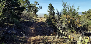
Pinch of Fab guarded by Better Hikes
by joebartels

  Likely In-Season!
Overview
Charcoal Gulch Trail #9419 begins at the Green Gulch TH. The final leg utilizes old Bannie Mine Road aka FS 9426 to an unsigned(needs to be verified) junction with Nemo Spring Trail #9405. FS 9426 continues down, yet there is no difference in the scree-filled luge-track that once was Bannie Mine Road.


Hike
Head west on the double-track trail. Hiking is very easy but you might cross side to side depending on which side is more favorable. 0.5 mi in Nemo Spring Trail #9405 hooks left. Ignore a right at 0.7 mi. At 0.95mi/160ft the easiest grade is over, Red Mountain Trail #43 continues forward and Charcoal Gulch Trail #9419 turns left.
remove free decal offer
The trail narrows and incline doubles but it's still easy. Watch your step for easily avoidable ankle buster rocks. The chaparral lined trail is mostly Mountain Mahogany. No catclaw riddled horror or notable bushwhacking on most of these Bradshaw OHV trails. One-seed Junipers and oaks increase at 1.3mi.

About 2.25 mi in it feels more prime hiking vs OHV. In the next half mile the trail dips though a tributary with Charcoal Spring (off-trail 750 ft up) before going around Upper Charcoal Tank. The trail has plenty of shade for almost a mile to the origin of Charcoal Gulch.

Salida Trail #93 turns right at 3.7 mi, which happens to be within ft of the highpoint for Charcoal. A 0.4 mi RT ascent up #93 takes you to 6,730. An excellent break option with views. However, shade favors late afternoon for favored positional views. If you're looking for an out-n-back, 6,730 or the #93 junction might be your best turnaround.

Continuing on it an old road and the final tall pines are gone very soon. It's still a nice walk to 4.2 mi.

The trail utilizes old Bannie Mine Road at 4.5 mi. If you are determined, bring a rock gliding toboggan by 4.65 mi. I hiked the trail in reverse with Nemo first. It's no big deal ascending but do use caution descending as this guide reads. There are nice sections too. Just warning, the footing descending might be undesirable to some as the grade increases down to Nemo Spring Trail #9405.

Synopsis
For me, the trail offers a 3.5 out of 5 experience. The upper 2-ish miles are prime. Getting there won't interest thrill-seekers nor find it a thrill.

2020-04-30 joebartels
  • NE Bradshaws - Area Trails
    area related
    NE Bradshaws - Area Trails


Check out the Official Route and Triplogs.
Leave No Trace and +Add a Triplog after your hike to support this local community.

One-Way Notice
This hike is listed as One-Way.

When hiking several trails on a single "hike", log it with a generic name that describes the hike. Then link the trails traveled, check out the example.
WARNING! Hiking and outdoor related sports can be dangerous. Be responsible and prepare for the trip. Study the area you are entering and plan accordingly. Dress for the current and unexpected weather changes. Take plenty of water. Never go alone. Make an itinerary with your plan(s), route(s), destination(s) and expected return time. Give your itinerary to trusted family and/or friends.

 Permit $$
no fees or permits reported

if incorrect tell us about it

Prescott Forest
Prescott National Forest Pass

Only trailheads with six "amenities" have fees. Amenities are picnic tables, trash, toilet, parking, interpretive signing and security.


 Directions
or
 Road


To Green Gulch Trailhead
TH is the terminus of Newtown Ave on the edge of Dewey-Humbolt and large enough for many trailers. Trails from this TH are OHV designated. Trail #9419 starts at the domed ATV Cattle Guard.

0) Dewey-Humbolt 0.68 mi N on 69 from 169/69 (Mortimer Farms is SE)
1) Kachina Pl → 0.4 mi
2) Continue on Horseshoe Ln → 0.1 mi
3) Left on S Pony Pl → 495 ft
4) Right on Henderson Rd → 2.1 mi
5) Continue on Newtown Ave → 1.1 mi

Huge lot for cars and trailers.

From PHX (I-10 & AZ-51) - 2 h 5 min (109 miles)
From TUC (Jct 1-10 & Grant) - 3 h 32 min (214 miles)
From FLG (Jct I-17 & I-40) - 1 h 55 min (97.5 miles)
page created by joebartels on Nov 17 2012 12:00 am
 90+° 8am - 6pm kills
helpcorrectionissue

end of page marker