Route Editor

| Guide | ♦ | 2 Triplogs | 0 Topics |
details | drive | permit | forecast | route |
stats |
photos | triplogs | topics | location |
| 109 | 2 | 0 |
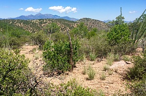
Highway to Hughes by AZHiker456   The subtitle I selected for this epic adventure to the summit of Mount Hughes is more than just a catchy subtitle. Whether you opt for an out-and-back via either the canyon or the ridgeline, or whether you combine both canyon and ridgeline into a loop as I’ve done, one thing [aside from sensational views and loads of fun] is guaranteed: the going is fast and smooth on this off-trail adventure. With many routes to assist you on most of the ‘off-trail’ segments, along with a few trails that are not shown on the topo, you will be cruising through most of this adventure instead of battling brush. The subtitle I selected for this epic adventure to the summit of Mount Hughes is more than just a catchy subtitle. Whether you opt for an out-and-back via either the canyon or the ridgeline, or whether you combine both canyon and ridgeline into a loop as I’ve done, one thing [aside from sensational views and loads of fun] is guaranteed: the going is fast and smooth on this off-trail adventure. With many routes to assist you on most of the ‘off-trail’ segments, along with a few trails that are not shown on the topo, you will be cruising through most of this adventure instead of battling brush.Hike Looking at a topo reveals there many options for hiking Mount Hughes. Below, I’ve detailed the lollipop-like loop that I completed. In addition to being relatively easy to access, this incredible loop will give you a grand tour of the beautiful surrounding area.
There is an opening toward the brush on the same side of the road with the small pullout type area to park. Walk toward this opening, and you will be treated to a full out trail. Although the trail does not appear on FS Topo, it is easy to locate, given that it is very distinctive and in better condition than many official trails; it is not some faint route that may be hard to find/follow. Within the first quarter-mile, the trail will intersect with a few jeep roads [also not shown on FS topo], and then it goes down to what appears to be an unnamed branch of the Cienega Creek. You’ll want to follow the creek SW for just under half a mile. The trail is well-defined at this point; but you can easily travel directly in the creek for added fun. Next, you’ll want to either bushwhack [or follow one of many routes] for about a quarter-mile to get over to FR 636. Due to the nature of this off-trail hike in combination with the many unnamed trails/routes, using a GPS app like Route Scout is highly recommended. Follow FR 636 to its southern terminus. This is where the real fun begins. You’ll want to get into Dark Canyon and head NW up the canyon. I flanked the Eastern side of the canyon for a short distance before dropping in, but it’s possible to make a more direct line in looking at a topo. The canyon is a super fun and beautiful traverse; and the footing is so good that I was literally “trail running” for parts of it. You’ll stay in the canyon for about 1.5 miles, at which point you’ll exit to ascend Mount Hughes. Again, using a GPS app like Route Scout will be extremely helpful. Since Mount Hughes is one of several peaks in the Canelo Hills situated above 5,800’ but below 6,000’, identifying it [and when to exit the canyon and begin your ascent] may not be obvious without the use of a GPS app. For those seasoned in off-trail peak bagging, the ascent up Mount Hughes will likely be fun and easy: nothing is overly steep in terms of grade, there is little to no loose/tricky footing, there are not tons of cacti to dodge, and there are even some faint routes. That said, given a few areas with FIELDS of shin-daggers, Mount Hughes apt to give you a few pokes before allowing you to reach the top. However, with sensational, 360-degree summit views, fighting your way through the shin-dagger fields is a small price to pay. The summit register is located under a cairn by the highpoint. Being a SAHC peak, Mount Hughes gets some amount of action; but like the nearby Kunde Mountain, there are not floods of folks bagging these peaks. The summit of Mount Hughes has three survey markers right in the area of the highpoint. One of them is situated at the bottom of the summit cairn, and the other two are out in the open nearby; they should be fairly obvious to spot if you’re walking about on the summit. Returning from Mount Hughes via the 4.75-mile ridgeline traverse is genuinely a fantastic experience. In addition to killer views, this is a really fun route that allows you to quickly cover tons of distance without constantly battling brush. For the first 3.35 miles or so, you’ll be on the Canelo Hills' main ridgeline that runs from the NW to the SE, and the last 1.40 miles is your ‘exit ridge.’ First, you’ll take the very short descent of under 1/10th of a mile off Mount Hughes to a small saddle between Mount Hughes and the next prominent point on the ridgeline. With a well-defined route and no shin-dagger fields to contend with, the descent off Hughes is quite pleasant. There is also a barbed-wire fence running off Mount Hughes that follows the ridgeline, and to top things off, the entire portion of the main ridgeline is also routed. Nonetheless, with the many minor ridgelines that extend off the main ridge, I can’t emphasize enough the importance of using a GPS app like Route Scout. I generally have a decent sense of direction [at least in terms of identifying which direction I came from / started from], but trust me when I say: this hike had me ‘turned around’ like no other! And, while the barbed wire fence may be reliable in keeping you on track after first coming off of Mount Hughes and shortly after that, further down the ridgeline, other intersecting barbed wire fences may make things confusing. Also, to get back to your starting point, you’ll eventually have to head in a different direction than the way the barbwire fence runs. The exit ridge begins at the prominent point located just SW of the end of FR 236; the next prominent point on the exit ridge is the one right by the end of FR 236; and the final one is UN 5731. Finally, a short bushwhack of about two-thirds of a mile from the top of UN 5731 will bring you back to FR 636, completing the loop portion of this extraordinary adventure. Check out the Official Route and Triplogs. Leave No Trace and +Add a Triplog after your hike to support this local community. | |||||||||||||||||||||||||||||||||||||||||||||||||||||||||||||||||||||||||||||||||||||||||