Route Editor

| Guide | ♦ | 2 Triplogs | 0 Topics |
details | drive | no permit | forecast | route |
stats |
photos | triplogs | topics | location |
| 19 | 2 | 0 |
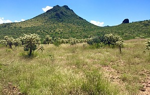
Come say hi to Diablo’s little brother by AZHiker456  On the East side of I-19 is the fun little pair of Elephant Head & Little Elephant in the Santa Ritas, while on the West side of the interstate lies the lesser-known pair of Diablo Mountain & Diablito Mountain, [aka Devil & Little Devil], in the Tumacacoris. The 4,070’ Diablito tops out nearly 900’ below its big brother, Diablo, and it’s also a much easier summit to attain in terms of terrain challenges. Nonetheless, the ‘Little Devil’ has its advantages: for those more seasoned in peak-bagging, it’s an ‘autopilot’ type of bushwhack; it doesn’t get crazily overgrown during monsoon/snake season, making it a very viable option year-round; and the trailhead is very accessible, located just 2 miles down FR 684 [aka “Hunter’s Access], just 5-10 minutes from I-19. On the East side of I-19 is the fun little pair of Elephant Head & Little Elephant in the Santa Ritas, while on the West side of the interstate lies the lesser-known pair of Diablo Mountain & Diablito Mountain, [aka Devil & Little Devil], in the Tumacacoris. The 4,070’ Diablito tops out nearly 900’ below its big brother, Diablo, and it’s also a much easier summit to attain in terms of terrain challenges. Nonetheless, the ‘Little Devil’ has its advantages: for those more seasoned in peak-bagging, it’s an ‘autopilot’ type of bushwhack; it doesn’t get crazily overgrown during monsoon/snake season, making it a very viable option year-round; and the trailhead is very accessible, located just 2 miles down FR 684 [aka “Hunter’s Access], just 5-10 minutes from I-19.Hike: Those in cars or high-clearance vehicles will want to park and start the hike about two miles down FR 684. There is a small sign to the right, which notes the following:
Sopori Ranch → ←Red Springs Pass Just before this sign to the right is a large clearing that makes for a perfect parking spot, and just after the sign to the right is an unnamed dirt road that will lead you to the base of Diablito Mountain. For those with Jeeps or 4x4’s, it’s quite possible to knock off a good chunk of road hiking by continuing in your vehicle down this unnamed dirt road. Most of the road is in very decent shape; but there are some places right in the beginning that will pose problems for cars and likely for most HCV’s, which is why I recommend parking in the clearing area just before the sign if you don’t plan on driving the unnamed dirt road. After about 2 miles of hiking [or driving] along the unnamed dirt road, there will be a couple of other intersecting, unnamed dirt roads. For this reason, I highly recommend using a GPS app like Route Scout for navigation; but those who are good with regular maps and experienced in off-trail peak bagging should have no trouble finding and bagging this peak. During the first two miles or so along the unnamed dirt road, the large prominent mountain to your left will dominate the views. This is Diablo Mountain and it’s a very fun adventure as well, [but one that I would not recommend during snake season!]. Diablito Mountain is the much smaller, much less prominent looking mountain located to the North of Diablo Mountain. Using HAZ Route Editor, I calculated the ‘as-the-crow-flies’ distance between the highpoint of Diablo and the highpoint of Diablito to be just under 2 miles. When the unnamed dirt road shifts from NW to N just over 2 miles into your hike, your objective, Diablito Mountain, will become much more obvious. Despite some closely spaced topography contours, several craggy areas, and some places that look like they could potentially turn into ‘oh ****’ types of moments from a distance, the Little Devil proved to be a lot easier than its big brother and was surprisingly approachable. Without a GPS app, it will be difficult to follow the exact route that I opted for from the dirt road to the summit and the summit back to the dirt road, but I’ll do my best to describe it; [that said, given the off-trail nature of peak-bagging, my route is merely a suggestion; after seeing the terrain, there look to be several other fun possibilities]: I arbitrarily began my bushwhack toward the summit of Diablito at just under 3 miles into the hike [and approximately 1 mile after passing an unnamed dirt road on the right, which ‘feeds in’ to the one I was one]. At this point, simply head toward what looks like the highpoint. Despite many craggy areas, there weren’t any surprises in terms of false summits; made just 1-2 places where I had to go slightly further than originally anticipated to reach the peak. It was surprisingly straightforward. And with good to excellent ground visibility, good gripping rock, some sturdy boulders to assist when things got steeper, and almost no cactus/thorny vegetation, it proved to be a very pleasant ascent. For once, it was almost like experiencing the opposite of the ‘oh ****’ effect, [where it feels like you’ve been approaching the summit forever as you inch up challenging terrain while getting nailed by thorns, only to find that you’ve advanced all but 100’]. If you follow my route [and have some experience in off-trail peak bagging], you will be pleasantly surprised at just how fast and easy this ascent is. The summit views are very beautiful; however, they are my least favorite relative to other summits/areas I’ve visited in the Tumacacoris. The likely reason for this is due to the mountain being located toward the outer part of the range where things start to flatten out, making for less interesting/beautiful views in some directions. There is a register nestled in the summit cairn, and it’s easy to spot but lacks a writing implement. Inside the register was some old paper that had started to mold. Without attempting to remove this paper, the only things I could make out were: the peak name, its altitude, and Mark Nichols [a peak-bagger who has signed & placed several other registers in the area, such as the ones on Horse Pasture Hill and Ritchey Peak in the nearby Sierritas, and likely was the one who placed the register on Diablito]. There was also a newer-looking business card that someone had left in the register, which was dated 11-15-13, along with the name of the peak. For my descent, I opted to head Northward, first angling to the NE and then to the NW. Like the side of the mountain that I ascended, there are also many craggy/cliffy areas on the side that I descended, but they were all easy to circumvent without going more than a few steps out of the way at any given time. And like the ascent, the good ground visibility, good gripping rock/footing, and lack of thorny vegetation made the going quick and easy. That said, an impressive display of cacti is encountered the moment you finish descending and start contouring the base of the mountain to get back over to the dirt road. However, with good footing and a few faint routes that provide a small margin of error between the many varieties of cactus, getting back over to the dirt is not difficult [or painful]. Once on the dirt road, you’ll go for approximately two-thirds of a mile before reaching Diablito Tank and then another seven-tenths of a mile or so before reconnecting with the spot where you departed from the road earlier in the adventure to bag the peak. Check out the Official Route and Triplogs. Leave No Trace and +Add a Triplog after your hike to support this local community. | |||||||||||||||||||||||||||||||||||||||||||||||||||||||||||||||||||||||||||||||||||||