Route Editor

| Guide | ♦ | 2 Triplogs | 0 Topics |
details | drive | permit | forecast | map |
stats |
photos | triplogs | topics | location |
| 48 | 2 | 0 |
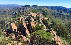
Southern Arizona’s Lost Dutchman by AZHiker456   The subtitle I choose is an overstatement, but the theme of long-lost treasure stashes is very fitting. While not nearly as well known as the famous legend of the Lost Dutchman’s Gold Mine, [and not nearly as valuable a treasure stash], the legend of the Silver Bullion at Sardina Peak is nonetheless very interesting. There are two variants of the legend that I’m aware of, and both are detailed in Ron Quinn’s book, Searching for Arizona's Buried Treasures: A Two Year Odyseey. At this time, the portion of the book detailing the legend, (Chapter 26, Pages 116-120), is freely available to the public via Google Books. The subtitle I choose is an overstatement, but the theme of long-lost treasure stashes is very fitting. While not nearly as well known as the famous legend of the Lost Dutchman’s Gold Mine, [and not nearly as valuable a treasure stash], the legend of the Silver Bullion at Sardina Peak is nonetheless very interesting. There are two variants of the legend that I’m aware of, and both are detailed in Ron Quinn’s book, Searching for Arizona's Buried Treasures: A Two Year Odyseey. At this time, the portion of the book detailing the legend, (Chapter 26, Pages 116-120), is freely available to the public via Google Books.Hike: About 7.1 miles down FR 684, there is an old, unmarked jeep road on the left. At the junction of FR 684 and this jeep road, which is located just past Upper Puerto Tank, there will be a small sign indicating that FR 684 continues to the right. I drove about 0.05 miles down the unmarked jeep road and found a small pullout on the left that made for a very nice parking spot. I don’t advise driving the jeep road unless you plan on taking an ATV [or have some serious off-road tires]. Sections of this road will max the limit of even the best-equipped jeeps & 4x4s.
After following the jeep road for about 1.35 miles to its ‘official end’ [as per CalTopo], it will then peter out for the next quarter-mile, while positioning you toward a ridge located to the North and slightly West of Sardina Peak. If you’re short on time or simply want to reach the peak in as little time as possible, then ride the rock spine of this ridge, which runs NW – SE, and it won’t be long before the solar panels that are situated on the summit come into view. If you enjoy experiencing some false summit fun, then simply head for what looks like the highpoint. This is what I opted for on my ascent, and it will position you on a ridge that runs NE – SW. After reaching the ridgeline, you’ll suddenly see that a bit more work is to be done before reaching the peak, [although at this point it goes by very fast]. This ridgeline is a bit ‘craggy’, but you will not cliff out. That said, the final part of the ascent does require a short section of basic, hand-over-foot type of scrambling with some mild exposure; so if this kind of thing is not your cup of tea, then definitely approach via the rock spine of the NW – SE running ridge instead. I descended the peak via this rock spine ridge and did not encounter any areas where I even came close to doing any hand-over-foot type of scrambling; there was no exposure. That said, both options are steep and very rocky. If you’re worried about twisting an ankle, this is not the hike for you! I did not find the footing to be loose per se, but given the grade and tons of rocks, the footing is likely to present challenges for those who are not accustomed to off-trail peak bagging. Know your limits/capabilities before embarking upon this adventure anything similar! The summit views are exceptional… about as beautiful as those from the nearby Atascosa Peak, [or very close to it]. Sitting at just over 5,600’, Sardina Peak is one of the big kids on the block, (ranking 4th highest of the 16 peaks in its quadrangle and 16th highest of the 103 peaks in its triangle + the surrounding 8 triangles]. As a result, the 360 views of the many unique shaped mountains in the immediate area and beyond are just spectacular. There is a register on the summit and it’s not too difficult to find. Simply head behind [South of] the solar panels and check among the rock piles. I think it was located within one of the first three rock piles. I’m not exactly sure which mini-rock pile was the tallest since several of them are similar in height, but for those concerned about setting foot on the highpoint point, simply head South across the summit to ensure you cover all of the ones in question. The highest part of the summit extends for only about 0.10 miles before dropping off, and then it’s worth checking out if anything for the breathtaking views. Return the way you came; do take extra caution if doing this hike during snake season! On my return trip, [while on an overgrown portion of the jeep road], I encountered a rattlesnake that did not want to move off the road. Check out the Triplogs. Note This is a moderately difficult hike. Leave No Trace and +Add a Triplog after your hike to support this local community. | |||||||||||||||||||||||||||||||||||||||||||||||||||||||||||||||||||||||||||||||||||||||