username
X
password
register
for free!
help


Llama Trail, AZ

Guide 14 Triplogs  0 Topics
  3.1 of 5  
Fav
Wish
0
details
drive
no permit
forecast
route  
stats
photos
triplogs
topics
location
92 14 0
Statistics
tap row or icons for details
Difficulty 1.5 of 5
Route Finding 1 of 5
Distance One Way 2.9 miles
Trailhead Elevation 4,401 feet
Elevation Gain -72 feet
Accumulated Gain 219 feet
Avg Time One Way 1.5 hours
Kokopelli Seeds 3.63
feature photo
Photos Viewed All MineFollowing
Inaugural Calculation on Button Tap!
9  2025-06-01
Intro to Sedona
mikemcg
6  2022-03-26
Little Horse Trail #61
squatpuke
4  2021-04-21
Slim Shady Loop
Nightstalker
19  2021-02-20
Little Horse and Llama Bail Loop
tibber
14  2020-09-19
Slim Shady Trail
Nightstalker
18  2020-02-15 DarthStiller
15  2020-02-15
Courthouse Butte Loop Trail
adilling
17  2019-09-28
Bell Rabbit Chicken Hog Church Cathedral Hi 2
The_Eagle
Page 1,  2
Author
author avatar Guides 8
Routes 0
Photos 0
Trips 9 map ( 73 miles )
Age 54 Female Gender
Location Mesa, AZ
Associated Areas
list map done
Sedona Region
Historical Weather
Trailhead Forecast
Radar Map
Expand Map
Preferred Mar, Nov, Apr, Feb
Sun  6:02am - 6:50pm
Official Route & 2 Rts
 
8 Alternative


alpaca free zone
by Ksorensen

 
The Llama Trail is a connector between the Little Horse Trail and either Bail Trail or Courthouse Butte Loop Trail.
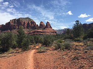

We had a shuttle available to us, so hiked one-way from the Broken Arrow trailhead, to the Little Horse trail, to Llama trail, to the Courthouse Loop Trail, to the Middle Trail, and eventually to the Bell Rock Vista Trailhead.
remove free decal offer
The Llama Trail afforded beautiful views the entire way and was considerably less crowded than Broken Arrow, Little Horse, or Courthouse Butte Loop trails. It is fairly flat, wide, and easy to follow. Although we expected a lot of bike riders, we were pleasantly surprised to run into only a few. Red Rock views abound across the entire length of this trail, and there are ample opportunities for exploration of red rocks off-trail. This was an extremely enjoyable trail. It affords almost no shade, so should be hiked in pleasant weather.

2017-05-04 Ksorensen
  • 2021 Verde Valley Trails
    region related
    2021 Verde Valley Trails
  • 2021 Verde Valley Area
    region related
    2021 Verde Valley Area
  • 2021 Sedona Trails Map
    region related
    2021 Sedona Trails Map


Check out the Official Route and Triplogs.
Leave No Trace and +Add a Triplog after your hike to support this local community.

One-Way Notice
This hike is listed as One-Way.

When hiking several trails on a single "hike", log it with a generic name that describes the hike. Then link the trails traveled, check out the example.
WARNING! Hiking and outdoor related sports can be dangerous. Be responsible and prepare for the trip. Study the area you are entering and plan accordingly. Dress for the current and unexpected weather changes. Take plenty of water. Never go alone. Make an itinerary with your plan(s), route(s), destination(s) and expected return time. Give your itinerary to trusted family and/or friends.

 Permit $$
no fees or permits reported

if incorrect tell us about it


 Directions
or
 Road


To hike
page created by The_Eagle on Nov 13 2016 2:16 pm
 90+° 8am - 6pm kills
helpcorrectionissue

end of page marker