Route Editor

| Guide | ♦ | 5 Triplogs | 0 Topics |
details | drive | no permit | forecast | 🔥 route |
stats |
photos | triplogs | topics | location |
| 103 | 5 | 0 |
Don’t Forget to Visit the Dams by AZHiker456   Nestled away to the North of the Huachucas, South of the Whetstones, and East of the Santa Ritas is a tiny range that receives comparatively little attention: the Mustang Mountains. Barely spanning 6 miles at the longest point and topping out at only 6,469’, [the highpoint of which is not even named], the number of miles to be hiked in this range and the highest point to be attained clearly cannot hold a candle to most of the neighboring ranges, [some of which top out at over 9,000’ and span well into double-digit mileage at the longest points]. However, if spectacular scenery, rugged off-trail adventuring, or bagging a remote peak that is easily accessible [even in a low clearance vehicle] is your cup of tea, then read on; the tiny Mustang Mountains can rival the big gun ranges in these regards. Nestled away to the North of the Huachucas, South of the Whetstones, and East of the Santa Ritas is a tiny range that receives comparatively little attention: the Mustang Mountains. Barely spanning 6 miles at the longest point and topping out at only 6,469’, [the highpoint of which is not even named], the number of miles to be hiked in this range and the highest point to be attained clearly cannot hold a candle to most of the neighboring ranges, [some of which top out at over 9,000’ and span well into double-digit mileage at the longest points]. However, if spectacular scenery, rugged off-trail adventuring, or bagging a remote peak that is easily accessible [even in a low clearance vehicle] is your cup of tea, then read on; the tiny Mustang Mountains can rival the big gun ranges in these regards.Hike Studying a topo map reveals several potential access points to the Mustang Mountains. The access point described here worked extremely well: there is an unnamed dirt road that begins off of Upper Elgin Road, and it runs due East, toward the Mustang Mountains. This road is located 2.05 miles down Upper Elgin Road if approaching from the center of Elgin, and 2.62 miles down Upper Elgin Road, if having come from Route 82. Almost immediately after turning onto this dirt road, you’ll need to get out and open a gate. The gate was not locked, it was very easy to open/close, and there was no sign indicating that motor vehicle traffic was prohibited; [in fact, a small sign on the gate indicated that it was a boundary for entering game management unit 35 A]. The road is in excellent condition and easily drivable in any high-clearance vehicle. With caution, a low clearance vehicle will likely be fine; however, the grass is quite tall in the center and, [given that it brushed the bottom of my Forester with 8.7” of ground clearance nearly the entire way], it will give a low clearance vehicle quite a beating. The good news is: that if you park by this gate, it adds just 0.95 miles each way.
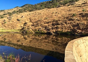
Just over a mile after the second gate, the dirt road ends [to motor vehicle traffic], and a strip of barbed wire fence has been constructed to prevent further vehicle travel. Although there is a sign stating that [the dirt road ahead of you] is “not a road” and that the area beyond the sign is closed to motor vehicle traffic but open to “foot traffic”, the dirt road continues beyond what is shown on topo maps, and it sets you up nicely to bag the highpoint of the Mustang Mountains [and/or several other amazing-looking peaks that this small range has to offer]. From this point, you are only about 1.5 miles from the summit of the Mustang Mountains Highpoint, UN 6469’. After following the portion of the dirt road that is closed to motor vehicle traffic for about 0.40 miles, you have two options: continue to approach the Mustang Mountains Highpoint to the SE; or follow my route which takes a small detour to the NE to investigate a neat dam built back in 1955. While it’s not the Hoover Dam by any stretch, it’s still really neat and not something you encounter on most summit hikes in Arizona. Etched in the concrete on the Southern part of the dam was: R.DE. P.R.B. 5/18/55 And on the Northern part was a longer inscription: OLD FORESTER BUILT BY ROY GREEN TUCSON AZ MAY 18-55 From the dam to the Mustang Mountains Highpoint is just under 0.90 miles; however, with frequent stops to enjoy the exceptionally beautiful scenery, [along with really slowing the pace to negotiate the increasingly rugged terrain toward the top], it took me about 1 hour to reach the peak from the time I left the dam. Initially, the going is quite fast for being off-trail. Aside from being a tad on the rocky side, the visibility was decent, the footing had good grip, the grade was relatively gradual, and there were many excellent animal routes/game trails to choose from. As you ascend, the grade gradually gets steeper and the footing gets slightly rockier, but nothing terrible at this point. About 0.15 to 0.25 miles from the peak, the landscape/vegetation will suddenly seem to change from high-desert grassland to forest [with even a few pine trees]. At around this same point, the grade gets much steeper and the footing becomes less reliable. While the softer dirt offers relatively decent grip, the steep grade, rocky terrain, and several places where the ground just kind of gives way underneath really requires some caution. I was extremely thankful to have taken my trekking poles and I highly recommend taking them if you’re the type to use them. Although challenging in some regards, the ascent was a walk through the park in others: there are virtually no thorns/brush to deal with and there are many routes to choose from; some of which appear to be animal routes and others that have been created/reinforced by humans, [based on the trash…]. Finally, aside from really having to watch the footing to avoid twisting/breaking an ankle, the ascent is quite fun, with lots of scrambling and a few spots that may require the use of hands/upper body, [but nothing overly difficult and/or close to a Class 3 climb]. As you near the summit, the tree cover will eventually thin out. There are a few prominent points, but the highpoint is relatively obvious and the views are exceptional. If the views are obstructed, then keep going; it means you haven’t hit the highpoint yet. There is a summit register under a rock pile that is located in the area of the highpoint. The design of the register is very similar to those I’ve seen on summits that get snow, consisting of a metal can with the opening facing down, under which is a smaller metal can with the opening facing up that houses the sign-in log. A final word about this summit: take caution if you are allergic to or frightened by bees. While I only saw a single bee, [and did not get stung or chased], the bee was not happy about my presence on the summit, and I was unable to stand in a single spot for more than 30-60 seconds without it circling me and giving me some definite warning buzzes. The return from the summit generally follows the ascent tracks but in reverse, first heading almost due North off the peak for about 0.25 miles, after which you’ll angle more toward the NW. The slight variation on the return trip occurs about 0.80 miles after having departed from the summit: instead of continuing NW [toward the dam], you’ll angle West and slightly South for about 0.40 miles toward another dam. Unlike the first dam, [which was completely dry when I did this hike], the second dam was filled with water, which made for some awesome photos and an easy landmark to aim for. With many animal routes/game trails, the going at this point is pretty easy for being off-trail; and the animal routes/game trails soon turn into what feels like a full-blown trail as you get closer to the dam. Like the first dam, this one also had some writing etched into the concrete but it was not as legible as the writing on the first one. The only lines I could make out definitively were the middle two, which revealed that it was built by the same person that built the first one: BUILT BY ROY L GREEN After checking out the dam, simply continue along the animal route/game trail that leads in the direction of the dirt road [West and slightly North]. About 1/4 mile after the dam, you’ll arrive back at the dirt road. Gate Policy: If a gate is closed upon arrival, leave it closed after you go through. If it is open, leave it open. Leaving a closed gate open may put cattle in danger. Closing an open gate may cut them off from water. Please be respectful, leave gates as found. The exception is signage on the gate directing you otherwise. Check out the Official Route and Triplogs. Note This is a moderately difficult hike. Leave No Trace and +Add a Triplog after your hike to support this local community. | ||||||||||||||||||||||||||||||||||||||||||||||||||||||||||||||||||||||||||||||||||||||||