 Route Editor

| Guide | ♦ | 1 Triplog | 0 Topics |
details | drive | permit | forecast | route |
stats |
photos | triplog | topics | location |
| 13 | 1 | 0 |
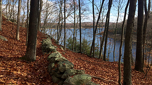
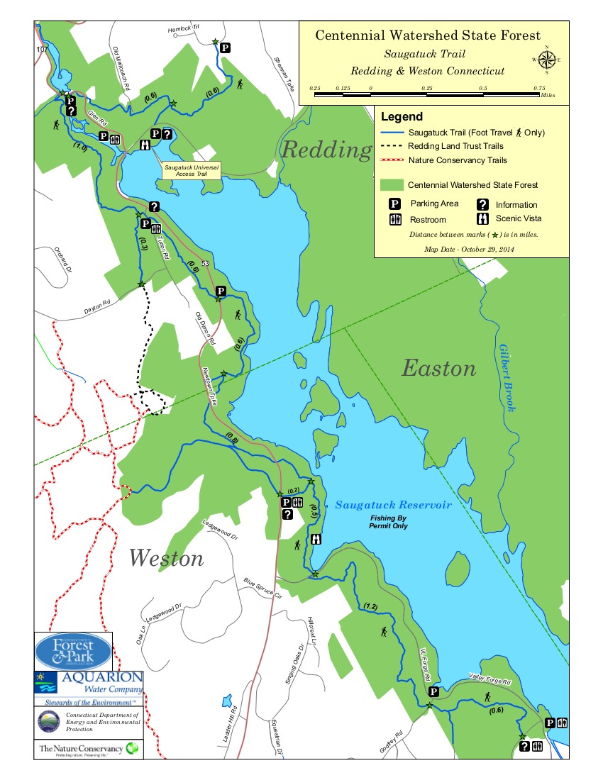
Nutmeg preserves by chumley History: Saugatuck is a native term that means "outlet of the tidal river". The Saugatuck River was dammed in 1938 and the result is the largest of 8 reservoirs that make up the greater Bridgeport water system now managed by the Aquarion Water Company. The trail is the result of a unique public-private partnership between the state of Connecticut, Aquarion, The Nature Conservancy, the Aspetuck Land Trust, and other smaller conservation groups who partnered to protect and preserve numerous parcels of land that spans the towns of Easton, Redding, and Weston.
There are portable toilets at some of the road crossings but rarely room for more than 2-3 cars to park. Though the reservoir is only 3.5 miles in length, the trail takes 5.5 miles to reach the north end where you cross the Saugatuck River by walking a short distance on Rte. 53. The trail leaves the road by going up a private driveway about 100 feet before a singletrack cut leads into the woods. In two more miles, the trail crosses another road and signs indicate that seasonal hunting here is open to both archery and shotgun. The next mile and a half the trail heads south along the east shore of the reservoir, passing the stone monument that marks the boundary between Easton, Weston, and Redding before heading east toward Black Rock Turnpike. The trail crosses an old wagon road on the east side of the lake that can be used to make a shorter loop hike from the northern end of the trail. The distance from the low point to the high point of this trail is less than 300 feet, but it is an endless roller coaster of ups and downs -- if only 20 or 30 feet at a time, but it adds up over 11 miles, and you'll get your gain in. Rocky ledges and marshy wetlands are plentiful, though the wet crossings are all traversed with wooden bridges. The Saugatuck Trail is one of the Connecticut Forest & Park Association's official Blue-Blazed Trails, where it is clearly marked with blue blazes on trees. An attentive user cannot get lost with the frequency of blazes. You will reach the end of the Saugatuck Trail at Black Rock Turnpike (Rte 58) in Easton. From here, the Aspetuck Trail takes over, continuing north 6 more miles to the Collis P. Huntington State Park. Connecting Trails: The southwestern portion of the trail has a connecting trail to the Nature Conservancy's Devil's Den Preserve, which features over a dozen miles of trails. The southeast side of the reservoir features the Aspetuck Land Trust's Trout Brook Valley Conservation Area. South of the dam is the popular Devil's Glen area along the Aspetuck River. Warning: Hunting is open to archers from October through December along most of the trail. On the east side of the reservoir a portion of the trail passes through land which allows shotgun hunting. Signs at all road crossings remind users of hunting season dates and suggests that hikers wear orange during hunting season. Hunting is prohibited on Sundays statewide. Permit and Rules: A permit is required to hike here. The permit is free and nothing more than a map of the trail which must be carried by one person in any hiking group. The map can be obtained at some of the trail access points or printed online here. The trail is open sunrise to sunset year round. Trail use is limited to hiking/running, cross-country skiing, and snowshoeing. No vehicles of any kind, motorized or non-motorized -- including bicycles -- are permitted. Camping, fires, swimming, wading, fishing, boating, or any flotation device are prohibited. Equestrian use is prohibited. Hikers must remain on marked trails. Off-trail use is prohibited.
Check out the Official Route and Triplog. Leave No Trace and +Add a Triplog after your hike to support this local community. One-Way Notice This hike is listed as One-Way. When hiking several trails on a single "hike", log it with a generic name that describes the hike. Then link the trails traveled, check out the example. | ||||||||||||||||||||||||||||||||||||||||||||||||||||||||||||||||||||||||||||||||||||||||


