Route Editor

| Guide | ♦ | 2 Triplogs | 0 Topics |
details | drive | permit | forecast | 🔥 route |
stats |
photos | triplogs | topics | location |
| 36 | 2 | 0 |
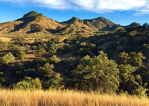
A Little Something for Everyone by AZHiker456   This versatile Patagonia summit hike is truly awesome. With sensational scenery throughout and under 0.10 miles of off-trail, the hike to Candelerio Peak is an excellent opportunity for those wanting a more rugged/remote summit hike without hours/miles on end of bushwhacking off-trail. And for those who enjoy off-trail peak bagging, a variety of possibilities exist. The lollipop loop route I’ve described below will fit a variety of levels. Those wanting the most-straightforward option & least amount of off-trail, follow the section below titled “Hike Approach” to reach the peak; then retrace your steps in an out-and-back fashion. Those who enjoy some added off-trail fun, continue to the “Hike Return” section to execute the lollipop loop. And for those who want even more of a challenge, many other nearby peaks can easily be incorporated into your route. Kunde Mountain, which takes off from the same trailhead, would be a great add-on. This versatile Patagonia summit hike is truly awesome. With sensational scenery throughout and under 0.10 miles of off-trail, the hike to Candelerio Peak is an excellent opportunity for those wanting a more rugged/remote summit hike without hours/miles on end of bushwhacking off-trail. And for those who enjoy off-trail peak bagging, a variety of possibilities exist. The lollipop loop route I’ve described below will fit a variety of levels. Those wanting the most-straightforward option & least amount of off-trail, follow the section below titled “Hike Approach” to reach the peak; then retrace your steps in an out-and-back fashion. Those who enjoy some added off-trail fun, continue to the “Hike Return” section to execute the lollipop loop. And for those who want even more of a challenge, many other nearby peaks can easily be incorporated into your route. Kunde Mountain, which takes off from the same trailhead, would be a great add-on.Hike Approach From the Harshaw Road Trailhead, follow the Arizona Trail heading to the NE, [left-hand side of the road if coming from Patagonia], for just under 4 miles. At this point, the Arizona Trail will intersect with a dirt road [left = dirt road, straight ahead = Arizona Trail, right = dirt road]. You’ll want to go left onto the dirt road [which is FR 138, although I don’t recall having seen a sign at the intersection]. About 1.10 miles after turning onto the dirt road [FR 138], you’ll come to another dirt road [FR 4602] on the right. Turn onto FR 4602. I recall having seen a sign for FR 4602 almost immediately after turning on it.
If you follow my GPS route exactly, you’ll reconnect with what appears to be a very old/overgrown dirt road just before reaching the summit. This road winds in front of a rock outcropping, which appears to have an old mine at its base. There is a flat dirt area in front of this outcropping, and someone constructed an arrow made from copper-colored rocks in this area. In the direction, the arrow is pointing [left], there is a faint route that switchbacks back and takes you above the rock outcropping. From this point, head Eastward toward the highpoint of the summit. The highpoint is relatively obvious, and there are some rock outcroppings to sit on while you soak up the spectacular scenery. There is a summit register among a rock pile located in the area of the highpoint. The first sign-in is from 2005, and this summit does not appear to get much action [at least not from hikers… when I visited this summit on 11/27/16, I was the first one to sign the log-in just over 3 years; enough said]. Hike Return For those wanting some added off-trail fun, the following option is a fun alternative to 7 miles of trail/road hiking back to the trailhead; and being a more direct route, you’ll shave off about 1 mile [though the time will likely end up being about the same / slightly slower]. Unless you are very seasoned in off-trail hiking without relying on GPS, then I highly recommend using Route Scout or another GPS app if you attempt this. According to FS Topo, you should be able to continue Southeast and then Southward on FS 4602, for about 0.75 – 1.0 miles from Candelerio Peak, at which point FR 4602 terminates at FR 4644; then hanging a right on FR 4644 and following it for about 0.15 miles will reconnect you with the Arizona Trail. However, satellite imagery reveals that you might have a bit of trouble finding a road leading Southeast from Candelerio Peak. After having been in the area where the road should have been, I can confirm this is the case. Continuing on FR 4602 will lead you to the base of Candelerio Peak on the SE side, at which point it peters out to nothing. At this point, you’ll have to freestyle your way back. If following my route, you’ll head SE, then Southward, and then SW, [for a total distance of just under 1.0 miles of bushwhacking], before reconnecting with the Arizona Trail; [you’ll want to take a right when you reconnect with the Arizona Trail]. After about 0.60 miles, you’ll arrive back at the same intersection described in the first paragraph of the “Hike Approach” section above, [left = dirt road, straight ahead = Arizona Trail, right = dirt road]. When you reach this intersection, you’ll have completed the loop portion of the ‘lollipop’. To get back to the TH, continue straight to stay on the Arizona Trail for just under 4 miles. Check out the Official Route and Triplogs. Leave No Trace and +Add a Triplog after your hike to support this local community. | |||||||||||||||||||||||||||||||||||||||||||||||||||||||||||||||||||||||||||||||||||||||||||||||