Route Editor

| Guide | ♦ | 2 Triplogs | 0 Topics |
details | drive | permit | forecast | 🔥 route |
stats |
photos | triplogs | topics | location |
| 47 | 2 | 0 |
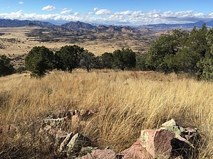
A Southern Arizona Must-Do by AZHiker456   As I pushed through patches of catclaw, glanced at the rather mediocre views [relative to what Southern Arizona has to offer], and crept up the less than perfect footing of the Northeastern ridge of the Pass Benchmark (BM), sarcastic subtitles, such as “Passing Time at Best”, “At Least Your Legs Will Get a Workout”, and “Masochist’s Alternative to AZT #3” came to mind. However, the moment I made summit, exceptionally beautiful views opened up to the South and Southwest, and my perception of this adventure instantly changed: instead of a mini-adventure to embark upon to kill time, this is one that you’ll want to incorporate into your itinerary if you are in the area. And, [contrary to any horrible imagines you might have after reading my opening sentence], there’s great news for those who are new to off-trail hiking and/or do not wish to embark upon an adventure that involves a high risk of getting torn apart by catclaw and/or rolling an ankle: the route I discovered on my return trip from the peak was one of the most pleasant and easiest that you’re going to find around the 6,000’ range in this part of Arizona. In fact, with excellent gripping footing, a relatively gradual grade, and almost no brush, the conditions of the terrain are better than many trails. To top all of that off, the ‘route finding factor’ is a non-issue, [to the point where this is one of the few off-trail summit hikes I feel very confident recommending without using a GPS app/device]. As I pushed through patches of catclaw, glanced at the rather mediocre views [relative to what Southern Arizona has to offer], and crept up the less than perfect footing of the Northeastern ridge of the Pass Benchmark (BM), sarcastic subtitles, such as “Passing Time at Best”, “At Least Your Legs Will Get a Workout”, and “Masochist’s Alternative to AZT #3” came to mind. However, the moment I made summit, exceptionally beautiful views opened up to the South and Southwest, and my perception of this adventure instantly changed: instead of a mini-adventure to embark upon to kill time, this is one that you’ll want to incorporate into your itinerary if you are in the area. And, [contrary to any horrible imagines you might have after reading my opening sentence], there’s great news for those who are new to off-trail hiking and/or do not wish to embark upon an adventure that involves a high risk of getting torn apart by catclaw and/or rolling an ankle: the route I discovered on my return trip from the peak was one of the most pleasant and easiest that you’re going to find around the 6,000’ range in this part of Arizona. In fact, with excellent gripping footing, a relatively gradual grade, and almost no brush, the conditions of the terrain are better than many trails. To top all of that off, the ‘route finding factor’ is a non-issue, [to the point where this is one of the few off-trail summit hikes I feel very confident recommending without using a GPS app/device].Below, I’ve described the most straightforward route [in terms of route finding & ease of terrain]. The Pass BM will be very obvious from the TH: simply look to the SW and the tallest peak insight is your objective. If you follow the route described below, your approach will involve heading West on the Arizona Trail, which will set you up very well to then ascend the peak via its very pleasant Northern ridge. If you’re more seasoned in off-trail peak bagging and would like a more challenging option, then I suggest just heading for the peak from the Trailhead as I did; my full route is posted in my triplog and is just one of many possibilities.
Starting from the Canelo Trailhead, begin by taking the Arizona Trail, AZT #3 [Canelo Hills West Trail], which you’ll take for approximately 1.15 miles. NOTE: I’m emphasizing the word “West” for those who might read this quickly and fail to note this detail: there are two segments of the AZT Trail that take off from the Canelo Trailhead, and the start of each is located just a few feet away from each other. One is AZT #3 aka Canelo Hills West Trail and the other is AZT #2 aka Canelo Hills East Trail. Therefore, you’ll want to remember to head West on AZT #3. After about 1.15 miles you will reach a saddle area. You’ll know you’ve reached the saddle area because there is a large metal gate with an Arizona Trail sign on it that you must unlatch to continue. Go through the gate, then turn left [Southward], and simply head upward until you reach the peak. NOTE: After turning upward, it may be helpful to follow the barb-wire fence line, which will lead you very near the summit. However, with that being said, I believe the fence line that runs upward from the gate interests with another fence at one point, [so just be sure to keep heading upward and it won’t be long before you reach the top of this awesome little peak]. It’s only about 0.50 miles from the point where you depart from the AZ Trail, [just after crossing through the gate] to the top of the peak. Gate Policy: If a gate is closed upon arrival, leave it closed after you go through. If it is open, leave it open. Leaving a closed gate open may put cattle in danger. Closing an open gate may cut them off from water. Please be respectful, leave gates as found. The exception is signage on the gate directing you otherwise. Check out the Official Route and Triplogs. Leave No Trace and +Add a Triplog after your hike to support this local community. | |||||||||||||||||||||||||||||||||||||||||||||||||||||||||||||||||||||||||||||||||||||||||||||||