username
X
password
register
for free!
help


Crossover Trail - Estrella Mtn RP, AZ

Guide 29 Triplogs  0 Topics
  2 of 5  
Fav
Wish
0
details
drive
permit
forecast
route  
stats
photos
triplogs
topics
location
7 29 0
Statistics
tap row or icons for details
Difficulty 1 of 5
Route Finding 1 of 5
Distance One Way 0.89 miles
Trailhead Elevation 1,152 feet
Elevation Gain 20 feet
Accumulated Gain 40 feet
Avg Time One Way 15 minutes
Kokopelli Seeds 1.02
feature photo
Photos Viewed All MineFollowing
Inaugural Calculation on Button Tap!
4  2025-07-03
Pedersen Trail - Estrella Mtn RP
Nightstalker
4  2025-06-25
EMRP Homestead Pedersen
Nightstalker
6  2025-05-07
EMRP Pedersen GNODS
Nightstalker
4  2025-03-08
EMRP Sand Loop
Nightstalker
6  2025-01-27
EMRP Sand Loop
Nightstalker
8  2025-01-07
EMRP Sand Punisher Loop
Nightstalker
6  2024-12-01
EMRP Sand Loop
Nightstalker
5  2024-11-28
EMRP Turkey Day Ride
Nightstalker
Page 1,  2,  3
Author
author avatar Guides 69
Routes 37
Photos 3,010
Trips 2,387 map ( 14,004 miles )
Age 55 Male Gender
Location Phoenix,Az
Associated Areas
list map done
Phoenix Region
Historical Weather
Trailhead Forecast
Radar Map
Expand Map
Preferred Jan, Dec, Feb, Nov
Sun  6:06am - 6:50pm
Official Route & 1 Rt
 
1 Alternative


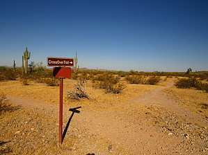
Breaking Boundaries
by mt98dew

 
Overview
Estrella Mountain Regional Park is located about 20 miles west and south of Phoenix in the foothills of the Estrella Mountains. It was established in 1954 with the purchase of 800 acres. Today, the Estrella Park stretches for almost 20,000 acres. It has a wide range of amenities, including horseback riding, a rodeo arena, golfing, fishing, baseball diamonds, a 65-acre grass picnic area, and trails for hiking and biking. The park has 14 trails that extend for 36 miles into the Park. This is one of the newest trails in the preserve, created a little over a year ago.


Hike
This is another one of those trails that you need to hike into the park to access. I would speculate that it was created more as a convenience for residents of the Estrella Mountain Ranch Community than for any other reason. The reason I say this is that there are two ways of reaching this trail. If you are hiking within the park, you have to hike 5 miles to reach this trail (via the Toothaker and Pedersen), and then, if you follow this trail, it runs for approximately 0.9 miles before terminating at the Preserve's boundary. The other way of reaching this trail to start from the Estrella Mountain Ranch Community (west of the Preserve) and utilize their trail system (yes, Estrella Mountain Ranch Community has an independent trail system adjacent to the Estrella Mountain Regional Preserve) to connect to the Crossover Trail. As far as I know, the Crossover Trail is the only trail that ties these two systems together.
remove free decal offer
The Crossover Trail heads in a westwardly direction undulating slightly as it progresses. As you proceed on clear, cold days, you'll see"clouds" emanating from the ground (Palo Verde Nuclear Plant), and closer in the foreground, you'll start to distinguish a brown, block-like building (Estrella Foothills High School). To the north, you'll have foothills of the Estrella's and to the south, is a large sandy wash. The wash is hard to see for most of the trail, but the green trees and shrubs that line it will identify its location. The trail itself does not change in elevation much, in fact, it only drops about 20 feet in the 0.9 miles. The trail is a dual-track that I (seriously) believe was constructed by driving a quad with a steel screen behind it. The trail is distinct but is still pretty rocky - racked rocks. The trail people did do an excellent job on the wash crossings. Five minor washes are transversed, and all of them have easy entry and exit points. At 0.9 miles, the Crossover Trail ends at a "fenced open gate". There is a pay station here for those who might be accessing the preserve from the Estrella Community. The Crossover Trail is currently not signed from this end. But as I said earlier, I believe it is the only trail that connects the two systems.

If you turn around at this point and return the way you came, you are looking at close to a 12-mile hike. If you continue into the Estrella Mountain Ranch trail system (via the PA trail), realize that it is 2 miles before reaching a TH, so you'll want to have a car waiting for you. Otherwise, it would be a 16 mile in and out. As of this writing, there is no loop attached to the Crossover Trail. Plus, please realize that the trails west of the preserve MAY be private property. The sign at the boundary stated "Estrella Mountain Ranch Private Property" and that "designated trails should only be used for hiking and biking". Not sure if trails are open to all or residents only. More to come, hopefully.

Water Sources
There are no water sources along this trail. But there is a drinking fountain at the Toothaker TH, which you would most likely use if you were starting from within the regional park. Realize this is 5 miles away from the Crossover Trail. There is also a drinking fountain at the Estrella Mountain Ranch Community TH. This TH is located just north of the Estrella Foothills High School, next to a bike track and a park. Realize this is 2 miles away from the Crossover Trail.

Gate Policy: If a gate is closed upon arrival, leave it closed after you go through. If it is open, leave it open. Leaving a closed gate open may put cattle in danger. Closing an open gate may cut them off from water. Please be respectful, leave gates as found. The exception is signage on the gate directing you otherwise.

2016-12-28 mt98dew
  • Estrella Baseline 2013 Map
    area related
    Estrella Baseline 2013 Map
  • 2020 Estrella Park Info
    area related
    2020 Estrella Park Info
  • 2020 Estrella Park Trails Map
    area related
    2020 Estrella Park Trails Map


Check out the Official Route and Triplogs.
Leave No Trace and +Add a Triplog after your hike to support this local community.

One-Way Notice
This hike is listed as One-Way.

When hiking several trails on a single "hike", log it with a generic name that describes the hike. Then link the trails traveled, check out the example.
WARNING! Hiking and outdoor related sports can be dangerous. Be responsible and prepare for the trip. Study the area you are entering and plan accordingly. Dress for the current and unexpected weather changes. Take plenty of water. Never go alone. Make an itinerary with your plan(s), route(s), destination(s) and expected return time. Give your itinerary to trusted family and/or friends.

 Permit $$
Maricopa Regional Parks - 2024 [ fees ]

$7 per vehicle, $85 annual or trade your firstborn for the life pass

$2 walk, bike, or horse ride into the park

2024 [ hours ] - varies by park & season


 Directions
or
 Road
Paved - Car Okay

To hike
To access this trail from the Estrella Mountain Regional Park...
From central Phoenix, head west on I-10 towards California. Take the Estrella Parkway exit and head south. Continue about four miles or so to West Vineyard Avenue. Turn left on Vineyard, and you'll pass a golf course. Keep your eyes peeled for the right turn into the park soon after the golf course. Take Casey Abbot Dr. and follow it around the perimeter of the park. This will eventually turn into 143 Dr. as it heads south and leads to the horse staging area. You'll want to park on the west side of the rodeo arena near the regional preserve map to access the Toothacher Trail.

To access this trail from the Estrella Mountain Ranch Community trail system...
From central Phoenix, head west on I-10 towards California. Take the Estrella Parkway exit and head south. Continue south for approximately 11 miles remaining on Estrella Parkway as you negotiate a round-about 8 miles in. About 3 miles past the round-about, look to the east side of the road for the high school. Park in the dirt lot on the north side of Estrella Foothills High School. The trail system begins just to the east of the BMX track.
page created by mt98dew on Dec 28 2016 8:57 pm
 90+° 8am - 6pm kills
helpcorrectionissue

end of page marker