Route Editor

| Guide | ♦ | 19 Triplogs | 1 Topic |
details | drive | permit | forecast | route |
stats |
photos | triplogs | topic | location |
| 232 | 19 | 1 |
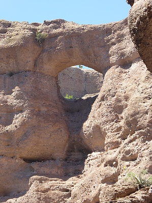
Canyons are inherently risky. Flash floods occur without notice on sunny days. Technical skills & surrounding topography knowledge required yet does not eliminate risk.
It was heaven, not hell by Steph_and_Blake  According to Wikipedia... According to Wikipedia..."Aravaipa Canyon Wilderness is a 19,410 acres (7,850 ha) wilderness area located in the U.S. State of Arizona. It forms the northwest border of the Galiuro Mountain range. The wilderness is administered by the BLM and is located northeast of Mammoth, Arizona in Graham and Pinal counties, about 120 miles (190 km) southeast of Phoenix. The wilderness includes the 11-mile (18 km) long Aravaipa Canyon, the surrounding tablelands, and nine side canyons." That description sounds somewhat boring and ho-hum, but we've been hearing praise about Aravaipa for years now. So, after having obtained the necessary permit ( see permit section ), we took off to see what all the talk is about. It was close to a 4-hour drive from our home in the east valley to the trailhead at the east entrance to the canyon. We camped that night at Fourmile Campground on BLM, but could just as easily have camped along Turkey Creek (a tributary to Aravaipa Creek). In the morning we donned shorts, old tennis shoes, and hiking gaiters (in hopes of keeping pebbles out of our shoes). We quickly understood why everyone gushes about Aravaipa. Having grown up in WVa, my hubby in northern Illinois, and our friends in the NJ countryside, we felt like we were kids again hiking through a creek in the midwest or east coast.
Check out the Official Route and Triplogs. Leave No Trace and +Add a Triplog after your canyon trip to support this local community. | ||||||||||||||||||||||||||||||||||||||||||||||||||||||||||||||||||||||||||||||||||||||||||||||||||||||||||||||||||||||||||||||||||||||||||||||||||||||||||||||||||||||||||||||||||||||||||||||||||||||||