Route Editor

| Guide | ♦ | 41 Triplogs | 3 Topics |
details | drive | no permit | forecast | 🔥 route |
stats |
photos | triplogs | topics | location |
| 318 | 41 | 3 |
Magic by Desertboots  We did this as a one-night backpacking trip on Oct 20-21. We started at Roger's Trough Trailhead. Joe and the others are correct in half the fun is the drive-in. It is necessary to have a high-clearance vehicle, and I would not go without a 4WD. We did this as a one-night backpacking trip on Oct 20-21. We started at Roger's Trough Trailhead. Joe and the others are correct in half the fun is the drive-in. It is necessary to have a high-clearance vehicle, and I would not go without a 4WD.A couple of friends and I did this in a two-car shuttle. We parked my jeep at the Woodbury Trailhead and my friend's truck at the Roger's Trough Trailhead, where we started. The trailheads are 3 miles apart and trust me when I say this, after coming out of the JF Trail at Woodbury Trailhead, you ain't a-gonna wanna walk 3 more miles up some very steep hills to Roger's Trough Trailhead! If you do this in a loop, use a two-car shuttle. I also must recommend starting at Roger's Canyon and ending on JF Trail. It's easier.
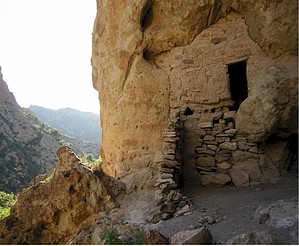
We started at about 10:45 am on Roger's Canyon Trail #110. It being mid-October, I think we were among the first hikers out in the Supers this season. They must have had a perfect summer because the trail was very overgrown. The water situation is apparently run-off based and not spring-based; it was dry as a pop tart. I hiked Roger's Canyon in April one year, and there was plenty of water in the drainage. Never underestimate your need for water, and I'll touch on this point a little later on. Also, I would like to recommend long pants and perhaps even a long-sleeved shirt. There were many a catclaw acacia gauntlets to run through on the trail, which left me sort of, well, pretty bloody. There is a nice place to take a break about half to maybe 3/4 of the way to Angel Basin. It's a clearing with a campfire ring made of stones and some logs to have a sit down on. After this, you'll climb over a little pass and down into the drainage area. There is a spot where you might lose the trail if you start going up the wash rather than crossing it. If you find yourself looking for the trail, look over to the other side of the wash, and you will see it climbing up the bank. The trail makes a gradual turn west. Look up to the right, and you'll see some caves. In there are the ruins. If you are camping, go a bit past this and you'll find some great places to camp. There is a little area under some oak just a little past the ruins, then there are some more campsites along the trail a little further (which is where we camped), and then there is Angel Basin. You can't miss this, as it is a large meadow. Beautiful area. Breathtaking rock formations, and excellent stargazing at night. I think it's a magical place. We pitched camp and went to explore the ruins. My friends climbed to the upper ruin, but I was not confident enough about that. The last time I was here, there were bits and pieces of broken pottery scattered around. I didn't see any this time. Please, folks, leave it be. Don't take anything. It's fun to have artifacts in your collections, I know, but it spoils it for the rest of us who would like to enjoy seeing traces of pre-historic human creativity right there at the site. The ruins are cool, but it's neat to see other stuff there as well. If you want Indian pottery, buy it. You can get some nice, unbroken objects in the art galleries around the state. You will help the artist by making a purchase, so it's a win-win situation. Back at camp, I discovered a small tarantula making its way toward my backpack. I made one of my companions adios it because I am arachnophobic. I had the willies for the rest of the evening. The next morning, we got going at about 7:55 am. We hiked up the JF Trail on a gradual climb to Tortilla Pass. This was a challenge because of the overgrowth, but it may get better with use throughout the season. Once you start switchbacking up to the pass, it clears out, and you have some terrific views of everything around you. You can even see the top of Four Peaks if you look toward the northwest. Once you go over Tortilla Pass (it was not marked when we were there), you begin to descend. You will descend for a long, long time. The trail is pretty much scree, so hiking poles are a great help. The trail levels out for a little while, and there are some shady spots to rest. It was here I ran out of water, and I lost a pin on my backpack (Kelty Tioga for Women). Great. We managed to fix it with a small substitute part, so I didn't have to ditch the pack. ( only ditch gear in an authorized trash receptacle ) You bottom out at Randolph Canyon Wash. At one point, I must warn the reader. It looks as if the trail goes into the wash and keeps going from there. It does not. Look for the trail going on straight ahead. Like I said before, it was overgrown, and sometimes hard to see the trail. The trail will lead to a Windmill, and this is the Woodbury Windmill. We had a copy of Hiker's Guide to the Superstition Wilderness by Jack Carlson and Elizabeth Stewart. This is an excellent and valuable book, and it saved our lives. If we hadn't had it, we would still be out there looking for the Woodbury Trailhead. Unfortunately, though, there isn't a description of the JF Tail coming to the Woodbury Trailhead, only going from it. So we had to read backward. The map didn't include the Woodbury Windmill; it only referenced it in the narrative. One of my companions read the map as it was, and it looked like we were about 2-3 miles off course. The windmill on the map is the windmill at JF Ranch. We didn't know where we were! We had no water. It was hot out. That is a terrible thing. It was the very first time I have ever run out of water on a trail. Here is where I will remind you that you should never underestimate your need for water. No food + no water + lost = deep in the hurt locker. We walked to the Windmill, and I was hoping there was water there, as what are windmills for? There are no trail indicators at the windmill, and the trails are not obvious at all. We walked on a trail past the windmill, as there were Cairns. After a while, we thought it felt wrong, and so we went back to the Windmill. There we found a tank with a trough and a water pipe with water coming out. We descended upon it with wild abandon. Like those movies, you see where someone is lost in the Sahara and comes across an oasis? I saw a trail heading south, and I thought it was what we wanted as the map indicated that we walk south from the windmill. I was right; we found the crossroads of the Coffee Flat Trail and the JF Trail. We were about half a mile to the trailhead. The thing to remember is, at the windmill, keep going south. From the trail sign, it looks like you can only go east or west, but the trail to the west curves due south. The trail leads up an old road, and once at the top, you will see the parking lot. Shangri-la. I apologize that I don't have any photos of the windmill area and the direction to go. I had run out of battery juice in the camera. It's a Canon Digital Elph. Also, I don't care how heavy it is, bring lots of water. Better to have too much. I bought a Magellan GPS this afternoon. Check out the Official Route and Triplogs. Leave No Trace and +Add a Triplog after your hike to support this local community. | ||||||||||||||||||||||||||||||||||||||||||||||||||||||||||||||||||||||||||||||||||||||||||||||||||||||||||||||||||||||||||||||||||||||||||||||||||||||||||||||||||||||||||||||||||||||||||||||||||||||||||