 Route Editor

| Guide | ♦ | 117 Triplogs | 9 Topics |
details | drive | no permit | forecast | 🔥 route |
stats |
photos | triplogs | topics | location |
| 1.6k | 117 | 9 |
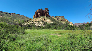
Balance of Adventure by joebartels   Overview OverviewRogers Canyon Trail #110 is a unique 4.9-mile wilderness experience from end to end. Salado ruins along the trail are a bucket list out-n-back destination hike. Angel Basin is a popular camping night for backpackers. Late October through mid-April offers the best weather. East Access Rogers Trough Trailhead - Follow Reavis Ranch Trail #109 for 1.65-miles to #110.
Woodbury Trailhead - Follow JF Trail #106 3.5-miles to #110 at Tortilla Pass. Hike From the east, #110 begins at a well-signed junction with #109. There has been a lot of vegetation growth since the 2019 Woodbury Fire. While it was easy to follow before and after the fire, it is questionable where to go as of this writing. Know that it is a sharp left turn. The trail crosses Rogers Canyon creekbed in 370-ft and crisscrosses the creekbed many times heading northwest to Angel Basin. Due to flooding and lack of use, portions of the trail are difficult to follow. Segments with catclaw are not luring the masses with the pain-free easy-to-travel creekbed a stones throw away. Rogers Canyon Spring is near 1.25-miles, west of the creekbed according to topo geographical maps. Except for one report of dripping in 2015, it is seemingly dry. The spring is intriguingly at the fork of a tributary from a hidden pocket. The trough downstream appears to have been filled in for 30+ years. Overhead geology kicks into overdrive by 2 miles along with large creekbed boulders. The Salado ruins are at 2.3 miles on the left, they are protected by federal law. After one last segment of a serene creek, catclaw encroaches as you reach Frog Tanks Trail #112 junction in Angel Basin at 2.65 miles. GPS and cairns are currently your best hope to continue to the western terminus at Tortilla Pass. If you can figure out the next quarter-mile have faith in knowing it gets better soon. Once you rise and are looking back down there are still a few route-finding blips but they are trivial comparatively. Great distant views open up. At 4.6 miles you reach an unnamed saddle, Roger's Saddle seems appropriate. Tortilla Pass and the end of the trail are an easy 0.3 miles further. It is the origin of Tortilla Creek that spans the wilderness to 11 miles as the crow flies to Tortilla Flats and Canyon Lake soon after. La Barge Mountain 5077 is a worthy off-trail hike from the pass. Camping Obvious options in Angel Basin and one primo site just east. Water Sources Angel Spring is unlikely unless you dig a well. Creekbeds flow and trickle for days after rain storms. A more reliable source is pooled water in Roger's Canyon along Frog Tanks Trail #112 en route to Rough Canyon. Synopsis The 2019 Woodbury Fire torched all except for 1.5-miles. I don't get excited about ruins or catclaw, but the large Arizona Sycamores and Arizona White Oaks in the sacrificed swath, fascinating geology, multi-seasonal wildflowers, diverse terrain and distant views will keep me returning. Warning Loppers, navigation skills, pants, long sleeve shirt, patience, and the skill to succeed are recommended for the full trail. 2-minute Video Check out the Official Route and Triplogs. Leave No Trace and +Add a Triplog after your hike to support this local community. One-Way Notice This hike is listed as One-Way. When hiking several trails on a single "hike", log it with a generic name that describes the hike. Then link the trails traveled, check out the example. | ||||||||||||||||||||||||||||||||||||||||||||||||||||||||||||||||||||||||||||||||||||||||||||||||||||||||||||||||||||||||||||||||||||||||||||||||||||||||||||||||||||||||||||||||||||||||||||||||||||||||||


