 Route Editor

| Guide | ♦ | 8 Triplogs | 0 Topics |
details | drive | permit | forecast | 🔥 route |
stats |
photos | triplogs | topics | location |
| 58 | 8 | 0 |
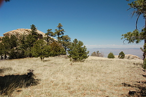
Believe me it's there by markthurman53  At one time, this trail was probably a very scenic trail along the Northern slopes of Mica Mountain, below Mica Lookout and Spud Rock to the Saddle east of Helen’s Dome. After Helen’s II fire in 2003, it is a trail through burnt trees either still standing or across the path. On the upside, if there is one, there are good views in the northern direction. The trail is still there just hard to locate in some places, but I had no problem staying on course with help from GPS. At one time, this trail was probably a very scenic trail along the Northern slopes of Mica Mountain, below Mica Lookout and Spud Rock to the Saddle east of Helen’s Dome. After Helen’s II fire in 2003, it is a trail through burnt trees either still standing or across the path. On the upside, if there is one, there are good views in the northern direction. The trail is still there just hard to locate in some places, but I had no problem staying on course with help from GPS.The North Slope Trail starts along the North Fire Loop Trail and heads down to Italian Spring. The Italian Spring area is moderately burned, but some pine and fir trees survived the fire. The area is recovering with new growth. Italian Spring is a far cry from what it looked like in 1970 with its dense Fir trees' forest. The North Slope trail heads west immediately at the spring, and the Italian Spring Trail heads north down the mountain (signed). The trail climbs a saddle and then over a small ridge and continues west, staying relatively level within an elevation window of 200 feet. The trail is relatively easy to follow for the first mile. As you approach just below Mica Mountain and Spud Rock, numerous tree falls concealed the trail. Follow your instincts, and as to where the trail is heading, and you will have no issues, A GPS is a nicety. Every so often, you will see the infamous red metal trail markers on a tree still standing or one on the ground to let you know you’re on the right track. Keeping on the route wasn’t that difficult compared to the continuous stepping over tree falls. The trail becomes more visible after about a quarter to half a mile as you approach the Saddle east of Helen’s Dome. The Pine trees become more abundant as the effects of the fire are less.
Check out the Official Route and Triplogs. Leave No Trace and +Add a Triplog after your hike to support this local community. One-Way Notice This hike is listed as One-Way. When hiking several trails on a single "hike", log it with a generic name that describes the hike. Then link the trails traveled, check out the example. | ||||||||||||||||||||||||||||||||||||||||||||||||||||||||||||||||||||||||||||||||||||||||||||||||||||||||||||||||||||||||||||||||||||||||||||||||||||||||||||||||||||||||||||||||||||||||||||||||||||||||||||||||||||||


