username
X
password
register
for free!
help
  This is likely a great time to hike this trail!  Check out "Preferred" months below, keep in mind this is an estimate.
 

Boulder Hop Trail #413, AZ

Guide 7 Triplogs  0 Topics
  3.3 of 5  
Fav
Wish
0
details
drive
no permit
forecast
route  
stats
photos
triplogs
topics
location
50 7 0
Statistics
tap row or icons for details
Difficulty 1 of 5
Route Finding 2 of 5
Distance One Way 0.8 miles
Trailhead Elevation 7,620 feet
Elevation Gain 70 feet
Accumulated Gain 70 feet
Avg Time One Way 30 minutes
Kokopelli Seeds 1.03
 Backpack Possible - Not Popular
feature photo
Photos Viewed All MineFollowing
Will recalculate on button tap!
3  2023-06-24
Aspen Trail #411 - Mogollon Rim
pseudalpine
23  2023-04-26
Bear - Woods Loop
LJW
20  2021-04-15
Bear - Woods Loop
LJW
15  2017-08-05
Highline - Drew - Woods Canyon - Sinkhole Loop
The_Eagle
15  2017-08-05
Highline - Drew - Woods Canyon - Sinkhole Loop
Tortoise_Hiker
Author
author avatar Guides 107
Routes 249
Photos 2,067
Trips 514 map ( 4,989 miles )
Age Male Gender
Location Phoenix, AZ
Associated Areas
list map done
Payson Region
Historical Weather
Trailhead Forecast
Radar Map
Expand Map
Preferred Jul, Aug, Sep, Oct → 7 AM
Seasons   Late Spring to Late Autumn
Sun  5:59am - 6:46pm
Official Route & 1 Rt
 
5 Alternative


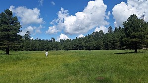
hip-hop and you don't stop the rockin'
by nonot

  Likely In-Season!
Overview
A short trail that splits the Aspen loop.

Hike
From the east side, the hike generally starts heading west at the signed intersection with the Aspen Loop Trail #411. After a short distance, the trail is signed as it leaves the old forest road and proceeds along a small knoll that sits between two meadows. This is the most scenic part of the trail.


About halfway through the trail, you climb a small hill and run into a vague section where the trail isn't clear due to recent logging activity. However, 50 yards later, the trail becomes clear. It proceeds slightly downhill and tracks a small drainage to the west, eventually reaching a T junction with the western side of the Aspen Trail.
remove free decal offer
The trail is not particularly well maintained as there is some overgrowth along most of the way, primarily small pine trees and grass, likely due to the low amount of trail usage. There are a few carsonite markers along the way, with a large "A" at the top. According to the Aspen Loop, this would make the trail part of the Aspen Loop Trail #411 itself, which obviously it is not.

I do not know why it is called the boulder hop trail...there are no boulders of note and no rock hopping required.

2021-07-18 nonot


    Check out the Official Route and Triplogs.
    Leave No Trace and +Add a Triplog after your hike to support this local community.

    One-Way Notice
    This hike is listed as One-Way.

    When hiking several trails on a single "hike", log it with a generic name that describes the hike. Then link the trails traveled, check out the example.
    WARNING! Hiking and outdoor related sports can be dangerous. Be responsible and prepare for the trip. Study the area you are entering and plan accordingly. Dress for the current and unexpected weather changes. Take plenty of water. Never go alone. Make an itinerary with your plan(s), route(s), destination(s) and expected return time. Give your itinerary to trusted family and/or friends.

     Permit $$
    None


     Directions
    or
     Road
    Paved - Car Okay

    To hike
    This is a connector trail with no trailhead. Most will access this trail after hiking a few miles of the Aspen Loop #411.
    page created by The_Eagle on Jul 18 2021 9:49 pm
     90+° 8am - 6pm kills
    helpcorrectionissue

    end of page marker