 Route Editor

| Guide | ♦ | 19 Triplogs | 0 Topics |
details | drive | permit | forecast | route |
stats |
photos | triplogs | topics | location |
| 2 | 19 | 0 |
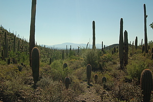
Good views to the East by markthurman53  Overview OverviewThis short 0.8-mile trail starts on the Cactus Canyon Trail 0.2 miles from its start at the Picture Rocks Wash Trail. The trail heads up a small canyon between two east-west oriented hills and tops out at a saddle between the two. Once on the saddle, the trail heads down to an east-flowing wash staying to the north side of the wash for about 0.4 miles, and then enters the wash for the rest of the trail to the Gila Monster trail. Hike The Coyote Pass Trail starts on the Saguaro Canyon Trail about 0.2 miles from the Picture Rocks Wash Trail. This trail heads to the east going up a small canyon between two east-west oriented hills. The trail follows along a small wash and climbs 40 feet in 0.2 miles to Coyote Pass. From the pass, the trail heads down along another small wash staying to the north of the wash for 0.4 miles before entering the wash and following it to the end of the Coyote Pass trail and the junction with the Gila Monster Trail. The trail is easy to follow but other than the start and end of the trail there are no signs indicating a trail, there were a few signs indicating old trails that are closed. For whatever reason, I found this trail interesting. The views to the east from the pass only added to the reasons why I liked this trail. This trail since it has no trailhead is used in conjunction with the Gila Monster Trail to form a longer loop hike. The Abington Trail that comes in from the east from Abington Road connects up with the Gila Monster Trail and opens up options for a few trails to the east of this.
Check out the Official Route and Triplogs. Leave No Trace and +Add a Triplog after your hike to support this local community. One-Way Notice This hike is listed as One-Way. When hiking several trails on a single "hike", log it with a generic name that describes the hike. Then link the trails traveled, check out the example. | ||||||||||||||||||||||||||||||||||||||||||||||||||||||||||||||||||||||||||||||||||||||||||||||||||||||||||||||||||||||||||||||||||||||||||||||||||||||


