 Route Editor

| Guide | ♦ | 14 Triplogs | 0 Topics |
details | drive | permit | forecast | route |
stats |
photos | triplogs | topics | location |
| 5 | 14 | 0 |
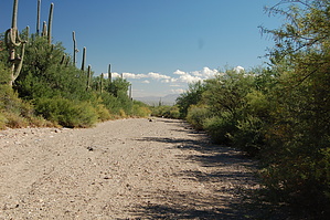
A long walk up a short sandy wash by markthurman53  Overview OverviewThe Picture Rocks Wash Trail’s eastern end starts at the Ringtail Trail and continues up the Picture Rocks Wash for about 1.5 miles, where it at one time ended at some point along the wash. The Park Service extended this trail 0.9 miles to connect up with the Prophecy Wash Trail to the west, making this trail 2.4 miles long. This description is from the west at Prophecy Wash to the east at the Ringtail Trail. From Prophecy Wash, the trail heads up a ridge that separates the two watersheds. From this ridge, the trail heads downhill for 0.7 miles and drops into Picture rocks Wash. The trail remains in the wash the rest of the way, passing by the Brittlebush Trail's junctions and its wash, the Ironwood Forest Trail, and the Cactus Canyon Trail. The Picture rocks Wash trail is the Major east-west trail on the northeast side of the park and can be used in part as a connector trail to the major north-south trails it crosses. Description From The Golden gate Road, the Prophecy Wash Trail heads upstream for 1.2 miles, where it connects up with the Picture Rocks Wash Trail. There is a sign hidden in the bushes that mark the trail. The sign isn’t hidden, but if you take the wrong channel of Prophecy wash, it is as good as hidden. I took the westernmost channel, and only by a little luck, I noticed the sign a couple of bushes over. If I were in the other channel of the wash, it would have been obvious. I had my GPS with me, and sooner or later, I would have figured it out. From Prophecy Wash, the trail heads east up to a ride about 100 feet up. Once on the ridge looking east is the Picture Rocks Wash watershed. The first 0.9 miles of this hike are along a trail not in a wash, and although it is rocky, it is a welcome relief from the sandy trails that are common on the north side of the park. The trail continues down from this ridge for 0.7 miles before dropping into Picture Rocks Wash where the trail remains the rest of the way. After 0.8 miles along the wash, the trail crosses another major wash that is the Brittlebush Trail. The Picture Rocks Wash before the Brittlebush Trail is narrow and does a lot of twists and turns, and is the most scenic part of this trail. After the Brittlebush Trail, the wash becomes very sandy and more difficult to walk in. Almost immediately after the Brittlebush is the junction with the Ironwood Forest Trail heading north out of the wash. Another 0.3 miles is the junction with the Cactus Canyon Trail and 0.4 miles later the end of the trail at the Ringtail Trail. It appears that if you continue down the wash, you will end up on Picture Rocks Road. The picture rocks Wash Trail is a good trail to use as a connector trail to other trails. Walking this trail after a summer monsoon where the wash has been running will make the walking easier. Gate Policy: If a gate is closed upon arrival, leave it closed after you go through. If it is open, leave it open. Leaving a closed gate open may put cattle in danger. Closing an open gate may cut them off from water. Please be respectful, leave gates as found. The exception is signage on the gate directing you otherwise.
Check out the Official Route and Triplogs. Leave No Trace and +Add a Triplog after your hike to support this local community. One-Way Notice This hike is listed as One-Way. When hiking several trails on a single "hike", log it with a generic name that describes the hike. Then link the trails traveled, check out the example. | ||||||||||||||||||||||||||||||||||||||||||||||||||||||||||||||||||||||||||||||||||||


